

Visitor Maps and Guides
Where will your next Grassland adventure take you? Check out our area maps, guides, and publications to help you plan your travel and recreation routes.
When in doubt, map it out.
Online Map Resources
Interactive Forest Visitor Map

The Interactive Forest Visitor Map is an online app that provides the public with information on Forest Service roads, trails, recreation sites, wilderness areas, and wild and scenic rivers.
Safety Reminder: Never count on your cell phone map as the only navigation device in the Grassland prairie.
Forest Service Digital Maps

Forest Service Digital Maps are a series of maps that cover all lands managed by the USDA Forest Service. These maps include national, regional, administrative, forest, ranger district, and topographic maps.
Safety Reminder: Never count on your cell phone map as the only navigation device in the Grassland prairie.
Avenza Mobile Device Maps

The free Avenza mobile app allows you to easily download forest maps to your device. Because Avenza maps are georeferenced, you can see your location on the map even without WIFI or network service. Your device’s GPS pinpoints your exact position on the downloaded map.
To view Avenza instructions for Android or iPhone, click here.
Safety Reminder: Never count on your cell phone map as the only navigation device in the Grassland prairie.
Google Play - USDA Forest Service Maps

The Google Play Store offers a collection of USDA Forest Service apps that provide users with offline maps, trail information, recreation sites, alerts, and other visitor data for National Forests and Grasslands across the United States.
Safety Reminder: Never count on your cell phone map as the only navigation device in the Grassland prairie.
US Geological Survey (USGS) Store

The United States Geological Survey (USGS) Store is an online platform within the Department of the Interior where you can purchase topographic maps, historical maps, Landsat state maps, national park maps, prints of satellite images, and more.
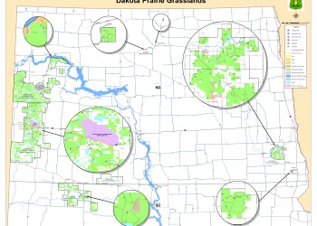
Dakota Prairie Grasslands Area Maps

Click the image to view in a full-screen version.
Printed grassland area maps are available for purchase at all five Dakota Prairie Grasslands Offices for $14, or online from the USGS Store.
Available grassland area maps include:
- Grand River National Grassland and Cedar River National Grassland (2009)
- Little Missouri National Grassland (2013)
- Little Missouri National Grassland -Maah Daah Hey National Recreation Trail (2018)
- Sheyenne National Grassland (2016)
Click an image to view the photo gallery in full-screen.

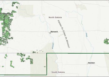


DPG Illustrated Area Map
The Dakota Prairie Grasslands map is a downloadable PDF illustration that displays the entire grasslands territories and established sites such as campgrounds, Interpretive sites, picnic areas, trailheads, and DPG offices. Download the map here.
Grand River National Grassland Maps
Little Missouri National Grassland Maps
National Grassland Maps and Resources for MVUM/OHV
LMNG - Use of Vehicles Off Road - Map - Order # 01-18-00-26-03 (downloadable PDF)

LMNG - Use of Vehicles Off Road - Map as per Order # 01-18-00-26-03