
Northern Hills - Spearfish
The Northern Hills Ranger District covers the northern portion of the Black Hills on the South Dakota side. Spearfish has nearby access to over 300 miles of snowmobile trails, groomed and ungroomed cross-country ski trails, a 100 mile long hiking trail (Centennial Trail) and many other trails, a 110 mile long biking, hiking and horseback trail (Mickelson Trail), and 1 downhill ski areas (ski area is near Deadwood, SD - 15 miles away).
Complexes


- A Variety of Uses
Dalton Lake Trailhead is a motorized and non-motorized trailhead for the Centennial Trail, a National Recreation Trail.
Roubaix Lake is a small lake located northwest of Rapid City and South of Deadwood, just west of US Highway 385. The lake provides opportunities for swimming, fishing and ice skating.

Roubaix Lake is a small lake located northwest of Rapid City and South of Deadwood, just west of US Highway 385.
This byway is the best place in the Black Hills to see waterfalls, including Bridal Veil, Little Spearfish & Roughlock Falls. The byway is a favorite fall color drive when the aspen changes in Sept. The Byway also follows an old railroad grade that was abandoned after massive flooding in 1933. Old rail stops & mining camps include Savoy & Elmore.
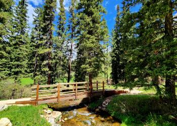
Located in Spearfish Canyon, along Spearfish Creek, Long Valley Picnic Area is a beautiful spot for a picnic.

The beautiful (approx. 60 ft. tall) Bridal Veil Falls waterfall can be seen from Highway 14A in Spearfish Canyon and is a popular destination.
- Overview
The Little Spearfish Trail is a 6 mile loop that meanders through stands of ponderosa pine, quaking aspen, and paper birch.
The Rimrock Trail can be accessed from the Little Spearfish Trailhead located near Timon Campground.


Hanna Nature trail is approximately 1 mile loop that begins and ends at Hanna campground.
Yates Ponds are approximately 1.3 acre ponds on Spearfish Creek. The Forest Service owns the shoreline.
In the Northern Hills Ranger District, the Eagle Cliff Ski Area is made up of 24 trails that include dedicated routes for both skiing and snowshoeing. This sprawling winter recreation area includes over 3 ½ miles of snowshoe routes and nearly 28 miles of ski trails. In the winter, the routes are managed in cooperation with the Eagle Cliff Ski Association, which grooms over four miles of trails on the southern-most portion of the area. From steep climbs and picturesque vistas to open meadows and mild terrain, Eagle Cliff Ski Area complements most any skill level. From the first snows that cover the canyons of Dead Ox Trail to the groomed runs and beginner area on Bratwurst and The Loop Trails, outdoor enthusiasts can create their own winter expeditions. The Eagle Cliff Trails were developed by local skiing enthusiasts in the mid 1980's and offers fun and challenges at every turn. We ask that snowshoers not use the groomed ski trails. Snowshoeing damages the tracks that the ski clubs work hard to establish and maintain. Eagle Cliff is a remote recreation site, located near Highway 85, approximately fourteen miles southwest of Lead, South Dakota.
Bratwurst Trailhead is one of two facilities accessing the non-motorized Eagle Cliff Trails.
Holey Rock Trailhead is one of two facilities accessing the non-motorized Eagle Cliff Trails.
Five trailheads provide access to the Centennial Trail in the northern Black Hills.The five trailheads are the Alkali Creek Trailhead (BLM), Elk Creek Trailhead, Dalton Lake Trailhead, South Boxelder Trailhead, and the Pilot Knob Trailhead. The north portion of the Centennial Trail is approximately 37 miles long, and is open for hiking, backpacking, horseback riding, and mountain biking. Off Highway Vehicles (OHV) less than or equal to 62 inches in width are allowed on the Centennial Trail between the Dalton Lake Trailhead and the Pilot Knob Trailhead.
NOTE: Backcountry camping options, park permits, and overnight parking requirements vary from one agency to the next. Interested hikers are encouraged to contact the respective agencies directly for specific guidance and updated policies.
- A Variety of Uses
Dalton Lake Trailhead is a motorized and non-motorized trailhead for the Centennial Trail, a National Recreation Trail.
Elk Creek Trailhead is the northern-most Forest trailhead on the multi-jurisdictional Centennial Trail, a National Recreation Trail.
South Boxelder Trailhead (also known as Blue Draw) provides both motorized and non-motorized access to the Centennial Trail, a National Recreation Trail.