
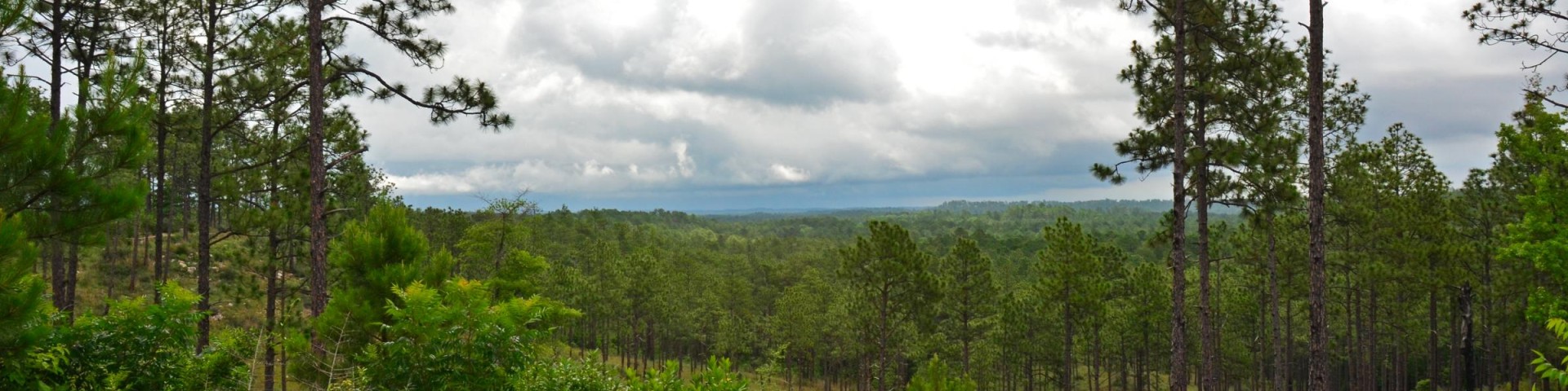
Welcome to Kisatchie National Forest
Located in seven parishes in central and northern Louisiana, Kisatchie's five ranger districts have a variety of recreational opportunities for everyone to enjoy and explore!
Eagle Nest Cams for Kisatchie National Forest
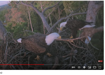
The Kisatchie National Forest Bald Eagle Cam nests are over 100 feet off the ground in the tops of loblolly pines near the shore of Kincaid Lake, which is located in the Calcasieu Ranger District, Evangeline Unit, Rapides Parish, central Louisiana, west of Alexandria.
Off-Highway Vehicle Trail Status

The Kisatchie National Forest has four off-highway vehicle trails to enjoy located in Vernon, Rapides, Grant, and Natchitoches Parishes. These trails may close due to excessive rainfall. Confirm trail status before you head out. OHV Hotline: (318)473-7069
Hunting on Kisatchie

Louisiana is not called "Sportsman's Paradise" for nothing! Some of the best hunting and fishing may be found on the Kisatchie National Forest. Hunters are expected to follow the Louisiana Department of Wildlife and Fisheries hunting regulations and guidelines.
Kisatchie's Five Ranger Districts Spanning Over 604,000 Acres
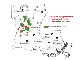
With over 183,000 acres divided into two units, Vernon Unit (near Leesville) and Evangeline Unit (near Alexandria/Pineville), the Calcasieu District is filled with beautiful longleaf pines, pitcher plant bogs, serene lakes, and scenic trails.
Visitors to the 85,000-acre Vernon Unit in Vernon Parish can enjoy the recreation serenity of a longleaf pine ecosystem and the historic past of Fullerton Lake Recreation Complex and the beauty of Little Cypress Recreation Complex. Fullerton Lake Recreation Complex was once the site of the Fullerton Sawmill and community, which was placed on the National Register of Historic Places in 1986. Ruins and foundations of the largest sawmill operation west of the Mississippi River may be seen on the 1.6-mile Fullerton Mill Trail. This trail is dotted with QR codes to allow visitors to enjoy a self-guided tour of this unique area. Fullerton Lake offers a variety of recreation options including camping, fishing, non=motorized boating, and a group-picnic shelter. Little Cypress Recreation Complex features a 3-acre spring-fed pond surrounded by the 0.5-mile, fully-accessible Ol' Sarge Interpretive Trail. Wolf Rock Cave may also be found on the Vernon Unit and is best described as two small rock overhangs overlooking Bundick's Creek. It is the only known rock shelter in Louisiana used by its early people, dating back to the Late Archaic time period, 2500-1000 BC.
Visitors to the 97,000-acre Evangeline Unit in Rapides Parish can enjoy panoramic views from the shores of Kincaid Lake, swimming, boating, picnicking, hiking, camping, and biking at the Kincaid Lake Recreation Area. Some activities are available year round. In spring, the wild azaleas and dogwoods are spectacular. In the fall, the mixed hardwood-pine forest provides wonderfully contrasting scenery. The Kisatchie's resident eagles may be spotted along the shore of Kincaid Lake or soaring over the forest. Valentine Lake, which was constructed by the Civilian Conservation Corps, offers a beautiful setting for picnicking and fishing. Bikers and hikers can enjoy numerous trails around Kincaid and Valentine Lakes. The Wild Azalea National Recreation Trail's 26-mile length offers day hikes along several segments or a two-day hike for those who want to get away for awhile. The Claiborne Multiple-Use Trails offer over 88 miles of motorized, horse, hiking, and biking use.
Download and print the Calcasieu Ranger District Vernon Unit and the Calcasieu Ranger District Evangeline Unit recreation brochure and maps for more recreation information and details.
Download and print the Calcasieu Ranger District Motor Vehicle Use Maps to discover where you may drive your vehicle or off-highway vehicle on national forest lands.
District phone number: (318)793-9427.
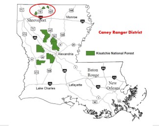
Near the state line of Arkansas, the 32,000-acre Caney Ranger District is a fisherman's dream with serene Caney and Corney Lakes. Visitors can enjoy a wide variety of recreation opportunities such as picnicking, camping, hiking and biking, boating, and fishing. A forest area restored from sugar cane and cotton fields, the Caney Lakes Recreation Area offers easily accessed shoreline that provides a scenic setting for a wide variety of recreation opportunities including a separate group use area and picnic shelter, water skiing, and hiking and biking on the Sugar Cane National Recreation Trail. At Corney Lake Recreation Area, the beautiful 2,300-acre lake offers scenery of bald cypress, tupelo gum bottomlands, and breezy upland pines.
Download and print the Caney Ranger District recreation brochure and map for more recreation information and details.
Download and print the Caney Ranger District Motor Vehicle Use Maps to discover where you may drive your vehicle or off-highway vehicle on national forest lands.
District phone number: (318)927-2061.
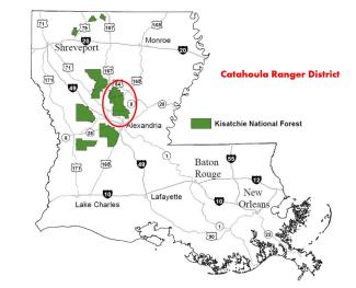
With its close proximity to Alexandria and Pineville, this 121,500 acre-District is popular with residents of Rapides and Grant Parishes as they explore the piney woods and hardwood bottoms on one of the many trails. Visitors to this Ranger District can enjoy the picturesque setting at Stuart Lake Complex, hike or bike along the Glenn Emery Trail, ride an ATV on Camp Livingston Multiple-Use Trails, or hunt the many game seasons. Viewing wildlife at Iatt Lake Observation Pier or at the Catahoula Butterfly Garden is also available.
Stuart Lake was originally created as an irrigation reservoir for the Civilian Conservation Corps-constructed Stuart Nursery. This peaceful 5-acre lake is surrounded by a mixed pine/hardwood forest setting. Recreation opportunities offered at Stuart Lake include picnicking, swimming, fishing, trail hiking, biking, and a separate group picnic shelter. Trails include the Glenn Emery Hiking Trail (~4 miles) and two OHV trails at Camp Livingston Multiple-Use Trail System. The Catahoula National Wildlife Management Preserve is located on both the Catahoula and the Winn Ranger Districts.
Download and print the Catahoula Ranger District recreation brochure and map for more recreation information and details.
Download and print the Catahoula Ranger District Motor Vehicle Use Maps to discover where you may drive your vehicle or off-highway vehicle on national forest lands.
District phone number: (318)765-3554.
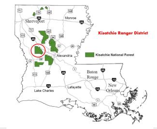
With a little over 102,000 acres of scenic vistas, byways, pine trees and bayous to explore in Natchitoches Parish, the Kisatchie Ranger District is truly unique. With its panoramic views from sandstone bluffs at Longleaf Vista, white sandy beaches and rocky rapids of Kisatchie Bayou, and a nationally designated wilderness area in Kisatchie Hills, visitors will fall in love with the district named after the Kisatchie National Forest.
The Longleaf Vista Recreation Area lies on a ridge that provides excellent views of the 8,700-acre Kisatchie Hills Wilderness, which surrounds the Vista on three sides. This popular day-use recreation area offers a variety of opportunities including picnicking, a ~ 1-mile trail, and access to the wilderness. The Kisatchie Hills Wilderness Area is a favored place among hikers and horseback riders who often enter along the Backbone Trail. Kisatchie Bayou Recreation Area offers day-use picnicking, swimming, fishing, canoeing or kayaking on the bayou, and hiking. Camping areas are oriented towards walk-in tent-camping along the banks of the bayou. Biking and horseback riding may also be enjoyed on the beautiful ~ 10.5-mile Caroline Dormon Trail.
The Kisatchie Ranger District offers visitors numerous activities that include multiple scenic overlooks, 12 miles of wilderness hiking trails, 20 miles of canoeing or kayaking down Kisatchie Bayou, 50 miles of multiple-use trails, and a 17-mile national scenic byway. The Red Dirt National Wildlife Management Preserve is a popular area for various hunting opportunities. Visit our hunting page to download the current season permit required to hunt in the preserve.
Download and print the Kisatchie Ranger District recreation brochure and map for more recreation information and details.
Download and print the Kisatchie Motor Vehicle Use Maps to discover where you may drive your vehicle or off-highway vehicle on national forest lands.
District phone number: (318)472-1840.

With over 164,000 acres to explore in Winn, Natchitoches, and Grant Parishes, visitors to the Winn Ranger District can enjoy the recreation serenity of an upland pine ecosystem, the historic past of Gum Springs Recreation Complex, and float along the bottomland hardwood forest of scenic Saline Bayou National Wild and Scenic River.
Located in an area of hilly terrain and natural springs, Gum Springs Recreation Complex exhibits recreation design from the Civilian Conservation Corps era of the 1930's and offers basic recreation opportunities of picnicking and camping, an dis close to Gum Springs Horse Camp and Trail. Approximately 21 miles of Saline Bayou was designated a National Wild and Scenic River because of its unique qualities. It is a peaceful setting where bald cypress and other hardwoods growing along the banks are often reflected in the bayou's quiet water. The bayou can flow over its banks during high water making the journey hazardous. It is always best to check with the District first about current water conditions. Cloud Crossing Recreation Complex lies directly on the banks of Saline Bayou an dis an ideal put-in/take-out point for boating, canoeing, or kayaking.
Download and print the Winn Ranger District recreation brochure and map for more recreation information and details.
Download and print the Winn Motor Vehicle Use Maps to discover where you may drive your vehicle or off-highway vehicle on national forest lands.
District phone number: (318)628-4664.