
Air Resource Information Monitoring

An important component of the Region 1 Air Resource Monitoring (R1 ARM) program is monitoring of air quality and Air Quality Related values (AQRS's) in or around Class 1 areas. In 1977, Congress designated certain wilderness areas, national parks, and international parks as Class 1 in order to protect their pristine air quality. The Class 1 Areas in Region 1 are the Bob Marshall Wilderness, Scapegoat Wilderness, Gates of the Mountains Wilderness, Anaconda-Pintler Wilderness, Selway-Bitterroot Wilderness, Mission Mountains Wilderness, and Cabinet Mountains Wilderness. Many of the AQRV's (such as lakes, visibility, biota, etc.) in Region 1 wilderness areas can be degraded by excessive air pollution impacts. Specific AQVR monitoring plans have been developed for each of the 7 Class 1 areas in Region 1. These plans include a specific analysis of existing and potential air pollution problems that could affect wilderness AQRV's. The plans establish the appropriate inventory and monitoring program for each Class 1 area. Smoke monitoring is useful to evaluate current smoke levels in regard to visibility and human health.
US Forest Service Air Resource Management

US Forest Service air quality site. Provides information about sources and effects of air pollution, Forest Service Air Management responsibilities, monitoring, smoke management, maps, class I area information, contacts, links, national and regional documents, definitions, and air quality data.
http://www.state.id.us/deq/air/air1.htm
Idaho Department of Environmental Quality DEQ's air program monitors air quality, develops permits that allow facilities to emit pollutants without violating air quality standards, and inspects facilities to assure compliance.
http://www.deq.mt.gov/AirQuality/aqinfo.asp
Montana Department of Environmental Quality DEQ directory of agencies, personnel, regulation, and links to other Montana air quality information
http://www2.nature.nps.gov/air/
The National Park Service Air Resources in conjunction with the Fish and Wildlife Service Air Quality Branch strives to preserve, protect, enhance, and understand the air quality and other resources of the parks and refuges under their care
http://www2.nature.nps.gov/air/permits/flag/index.cfm
Federal Land Managers Air Quality Group (FLAG) is an interagency workgroup whose objective is to achieve greater consistency in the procedures Federal Land Managers use in identifying and evaluating AQRVs (air quality related values).
Western Regional Air Partnership (WRAP) was formed to implement the recommendations of the Grand Canyon Visibility Transport Commission. As part of WRAP, The Fire Emissions Joint Forum was formed to address the recommendations regarding fire emissions and visibility.
Lake Monitoring

Lakes are an important wilderness Air Quality Related Values used to indicate air pollution levels. Approximately 200 of the 1750 lakes in Region 1 wilderness areas have been sampled since 1989. The sampling program has included a 3-phase approach. Phase 1 included measuring pH, alkalinity, conductivity, and documenting watershed factors (geology, vegetation, drainage characteristics) of 146 lakes. Phase 2 monitoring has been done in 176 lakes (many of which were also sampled in Phase 1) and included a more comprehensive chemical analysis (major cations and anions and ANC determination). Phase 3 "benchmark" monitoring has been done at 9 lakes in Region 1 with a current network of 6 lakes (2 in each of the Cabinet Mountains, Selway-Bitterroot, and Absaroka Beartooth Wilderness Areas). The Phase 3 lakes were selected because of the acid deposition sensitiviy and representativeness of other similar lakes in Region 1 wilderness areas. Phase 3 protocols include additional (to Phase 2) chemical parameters and some biological parameters. The lake monitoring has documented a wide range of lake sensitivities in region 1, controlled primarily by weatherability and alkalinity generation potential of bedrock parent material. Most of the Bob Marshall Wilderness complex, Anaconda Pintler Range, and Mission Mountain Wilderness have predominantly sedimentary parent material with lakes generally well buffered to pH change. The Selway Bitterroot, Absaroka Beartooth, and parts of the Cabinet Mountains Wilderness Areas have lakes with granitic and quartzite type parent material and some alping lake watersheds which have very limited soil and vegetation and lake chemistry which is poorly buffered and quite susceptible to atmospheric induced acidification, None of the lakes sampled in Region 1, however, are measurably damaged from acid deposition. Acid depostion sensitivity calibration of each of the Phase 3 lakes is being done with the Model of Acidification and Groundwater (MAGIC). The model calibrates lake chemistry to atmospheric deposition and watershed/soil/hydrology factors enabling a prediction of lake chemical response to potential upwind changes in emissions. The model is extremely useful in PSD analysis.

USFS R1 Lake Monitoring Sites.
USFS R1 Lake Monitoring Sites
Map based lake chemistry and stream chemistry database on National Forest lands. Includes USFS lake monitoring and the FPA Western Lake Survey in 1985.
Acid Deposition

The National Atmospheric Deposition Program (NADP) consists of about 200 sites in the US that continuously monitor acid deposition precipitation chemistry. Precipitation chemistry is affected by the upwind chemical environment that includes both natural and anthropogenic emissions sources. Region 1 installed a high elevation NADP site (MT97) at Lost Trail Pass on the Bitterroot National Forest that became operational in October 1990. The Lost Trail Pass gage is the only high elevation site in Montana or Region 1. The 1990-2004 wet precipitation had an average pH of 5.39 and sulfate of 0.21 ueq/L. These are low levels of acid deposition compared to more industrialized areas of the US but are similar to the 3 low elevation sites that occur within 25 miles of NF lands in Region 1. Wet chemistry deposition patterns at Lost Trail Pass have consistently had higher nitrate and sulfate concentration and correspondingly lower pH in spring/summer. The opposite is true during fall and winter. Reduced atmospheric temperature during the winter month's retards photochemical transformation of SO2 and NOx to sulfur and nitric acid. An apparent trend in the 1990-2004 data for Lost Trail Pass is a slight reduction in pH and sulfate, with a slight increase in NO3. The Lost Trail Pass NADP site has been a very useful component of the MAGIC modeling of Region 1 lakes.

Montana/Idaho NADP Sites.
National Atmospheric Deposition Program (NADP)
National Atmospheric Deposition Program Overview of NADP program, NADP/NTN data access, isopleth maps of acid deposition parameters, NADP contact information
Visibility Monitoring
Visibility is defined not only by how far you can see but how well you can see the details of the vista your viewing. The amount and kind of pollution in the air affects visibility. The Region participates with the Environmental Protection Agency, the National Park Service and the Fish & Wildlife Service to monitor visibility at Class I areas across the country. In Region 1, visibility is or has been monitored for the Cabinet Mountains Wilderness, the Bob Marshall Wilderness, the Selway-Bitterroot Wilderness and the Anaconda-Pintler Wilderness. On the clearest days in Montana and Idaho, a person can see more than 150 miles. On a more typical day, a person can see about 115 miles. On the haziest days, a person can only see about 60 miles. Compared to east of the Mississippi, we see twice to three times as far and as clear as they do. However, the area of the Colorado Plateau has even better visibility than we do.
What Affects Visibility?
Sulfur dioxide, nitrogen oxides and volatile organic compounds emitted primarily from power plants, other types of industry, and car and truck travel affect how well we see. These emissions can also be transported far from their source. Smoke from forest fires and agricultural fires contribute to the mix as well as wind blown dust. In the northern Rockies, we are most affected by nitrogen oxides and volatile organic compounds generated from transportation and industries. At times we can be impacted by sources as far away as the Pacific coast and Canada. Smoke also contributes to our haziest days.


USFS Region 1 NADP Sites.
Interagency Monitoring of Protected Visual Environments (IMPROVE)
IMPROVE program is an extensive long term monitoring program to establish the current visibility conditions, track changes in visibility and determine causal mechanism for the visibility impairment in the National Parks and Wilderness Areas. The purpose of this website is to provide access to the IMPROVE monitoring data resources and educational material on the science of visibility and regulations. First time visitors should visit the Overview section which summarizes the IMPROVE network and visibility science and regulations.
Smoke Monitoring
The primary pollutant of concern from smoke is particulate matter, or more specifically, PM2.5 which are smoke particles smaller than 2.5 microns. PM2.5 is of concern because of the health risks posed. PM2.5 can be respired deeply into the lungs and can transport toxins directly into the blood stream. The United States Environmental Protection Agency (EPA) has established National Ambient Air Quality Standards for PM2.5 at 35 µg/m3 for a 24-hour average, and 15 µg/m3 for an annual average. Areas of Lincoln County, MT surrounding Libby are in non-attainment for the annual standard, and the Montana Department of Environmental Quality is projecting that the following areas will be in non-attainment for the 24-hour standard:
• Libby (Lincoln County)
• Missoula (Missoula County)
• Hamilton (Ravalli County)
• Butte (Silverbow County)
Shoshone County in Idaho (Wallace, Kellogg) is also expected to be in non-attainment for the 24-hour standard.
The Northern Region maintains two DATARAM portable particulate monitors that are easily deployed to assess particulate levels resulting from wildland fire smoke. These monitors are also equipped with satellite uplink capabilities so the concentrations can be monitored in near real time over the internet. Nationally, the Forest Service also maintains an air monitoring cache if additional smoke monitors are needed.
In the absence of a monitor, particulate concentrations can be estimated from the visual range by using the following table:
| Health Category | 24-hour PM25 | 1-hour PM25 | Visibility (miles) |
| Good | 0 - 15 (AQI: 0 - 50) | 0 - 40 | 10+ |
| Moderate | 15 - 40 (AQI: 51 - 100) | 40 - 80 | 5 - 10 |
| Unhealthy for Sensitive Groups | 40 - 65 (AQI: 101 - 150) | 80 - 175 | 3 - 5 |
| Unhealthy | 65 - 150 (AQI: 151 - 200) | 175 - 300 | 1.5 - 3 |
| Very Unhealthy | 150 - 250 (AQI: 201 - 300) | 300 - 500 | 1 - 1.5 |
| Hazardous | ≥ 250 (AQI: 301 - 500) | ≥ 500 | < 1 |
Particulate Matter (PM 2.5) Concentration in Western Montana During the Wildfires of 2000 ppt (44.5 MB)
FCCS - Fuel Characteristic Classification System
VCIS - Ventilation Climate Information System
Montana.gov Air Quality monitoring
Interagency Wildland Fire Air Quality Response Program
Air Quality Monitoring | Montana DEQ
Fire Smoke & Health
Smoke and human health conference papers in Seattle (and Missoula), including 2000 wildfire smoke.
AirFire
Smoke and Fire website. Developed and maintained by the USFS Pacific Northwest Research Station.
BlueSky and BlueSkyRAINS
BlueSkyRAINS Weather Forecast maps for prescribed burning, wildland fires, and agricultural lburning: BlueSky & Rains
Rocky Mountain Fire Weather Info
Rocky Mountain Fire Weather Info Rocky Mountain Center: Real time fire weather intelligence & smoke forecasts for the Western USA
Lichens Monitoring

Lichens are effective bio-indicators of air quality. They are sensitive to high concentrations of gaseous pollutants such as sulfur dioxide, and are also known to accumulate and concentrate elements such as trace metals and sulfur. They are used to monitor long term changes in air quality in natural ecosystems.
Dr. Larry St. Clair, a lichen expert at Brigham Young University, has been analyzing lichens for the Northern Region since 1992. Dr. St. Clair and his staff performed the initial lichen surveys in the Anaconda Pintler, Cabinet Mountains, and Selway Bitterroot wilderness areas from 1992 – 1994. From 2000 – 2002 these three wilderness areas were re-surveyed, and initial surveys were taken from the Bob Marshall, Gates of the Mountains, and Mission Mountain wilderness areas. In 2007 - 2009, Dr. St. Clair and his staff will re-survey all six wilderness areas. The lichen surveys typically involve the identification of the lichen species, an interpretation of the health and diversity, an interpretation of the relative air pollution sensitivity, and the analysis of lichen tissue for air pollutants including sulfur and trace metals. In the 2007 – 2009 surveys, Dr. St. Clair will also be analyzing lichen species for total nitrogen.
Results from the 2000 – 2002 survey indicated that floras in all six wilderness areas are diverse and healthy. The abundance of pollution sensitive forms suggests minimal air-pollution related impact. Elevated heavy metal concentrations in samples east of the Anaconda-Pintler wilderness area are likely due to smelter deposition and debris from the Anaconda Smelter which shut down in September 1980. Four high elevation sites in the Selway Bitterroot wilderness area had moderately elevated sulfur concentrations, which may be due to long range transport.
Visit the Forest Service national lichens and air quality database and clearing house.
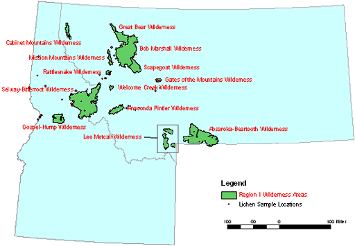
USFS R1 Lichen Monitoring Sites.
Snow Chemistry Monitoring

The United States Geological Survey (USGS) Water Resource Division in Colorado, in cooperation with the USFS, NPS, and multiple other agencies and interest groups has been monitoring 52 seasonal (late winter), depth integrated, bulk snowpack sites along the Continental Divide from New Mexico through Montana since 1993. Fourteen of these sites are near USFS R1 wilderness areas. These sites include include West Yellowstone, Canyon, Lewis Lake, Sylvan Lake, Big Sky, Daisy Pass, Lionshead, Snow Bowl, Granite Pass, Red Mountain Pass, Noisy Basin, Apgar Mountain, Banner Pass, and Galena Pass. Bulk late winter snowpack samples provide a very useful diagnosis of chemical deposition (H+, Ca2+, Mg2+, Na+, K+, HN4+, SO4+, NO3-, and Cl-) from all transport sources (short and long range) through the late fall and winter period. The samples are collected in a depth integrated fashion prior to spring snowmelt rinsing of the snowpack which quickly flushes the soluble chemical constituents from the snowpacks. The snowpack monitoring has documented generally decreasing levels of snowpack contaminants from south (New Mexico and Colorado) north through Montana. Montana and Northern Wyoming snowpacks have generally low (dilute) amounts of contaminants except samples collected near areas of heavy snowmobile use in YNP) and at the Lionshead site near West Yellowstone.

USGS Snow Chemistry Sites in USFS R1.
USGS Rocky Mountain Regional Snowpack Chemistry High Elevation Sites near the Continental Divide in Montana, Idaho, Wyoming, Utah, Colorado, and New Mexico. This site contains USGS snow chemistry publications including Yellowstone National Park snow chemistry/snowmobile studies.
Guidance

The Clean Air Act and subsequent amendments give Federal land managers an "affirmative responsibility" to protect Air Quality Related Values in Class 1 areas and to protect human health and basic resource values in all areas. For the R1 Forest Service much of the air quality protective responsibility is met by proper analysis and disclosure of air quality related effects of Forest Service management or permitted activities. Several guidance documents have been prepared for R1 Forest Service employee for use in preparing air quality sections of NEPA documents for smoke related impacts (prescribed burning or timber sales, oil and gas leasing, ski area construction and expansion) and for Forest Plan sub-Regional assessments, Analysis of the Management Situation, and Forest Plan Revisions.
Some guidance documents are available in multiple data formats. Click on the link for your preferred format following the name of the report.
Smoke NEPA Guidance -- Describing Air Resource Impacts from Prescribed Fire on National Forests & Grasslands of Montana, Idaho, North Dakota & South Dakota in Regions 1 & 4.
pdf (1.0 MB) | docx (2.8 MB)
SIS Smoke Impact Spreadsheet
Air Sciences website for downloading Smoke Impact Spreadsheet (SIS) and User's Guide
SIS Installation Guidance doc (14 KB)