

Hydrogeologic and Vulnerability Mapping
Hydrogeologic Mapping
 Geological mapping for hydrogeologic purposes focuses on the ability of the various rock units to store and transmit water. Hydrogeologic maps are produced from geologic base maps by assigning hydrogeologic properties to geologic units and then grouping them into aquifer units and confining units. Hydrogeologic information can come from previously prepared documents (i.e., professional reports and papers), well reports, available geologic logs, and geophysical logs. Additional data include aquifer hydraulic properties (transmissivity or hydraulic conductivity (K) and storage coefficients) and boundary conditions.
Groundwater Vulnerability Mapping
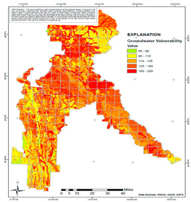 All groundwater is vulnerable to contamination from surface sources of pollution; however, some areas are more vulnerable than others. Vulnerability is commonly computed with the DRASTIC index method, developed by the U.S. Environmental Protection Agency (EPA). Based on the DRASTIC indices, areas can be classified based on their relative vulnerability. Typically, vulnerability maps indicate that alluvium and terrace deposits are most vulnerable and areas where igneous and low yielding bedrock is at or near the surface are the least vulnerable. Vulnerability maps can be used for individual projects as well as forest and grassland planning. In areas of karst, other groundwater vulnerability mapping methods are often used due to differences in the connection between the surface and the subsurface in karst, and rates of groundwater flow.
Geospatial Projects and Groundwater
The Forest Service Groundwater Program works with the Geospatial Technology and Applications Center through the Geospatial Technology and Applications Steering Committee to support groundwater and geoscience-related remote sensing projects on forests and grasslands across the country. Projects supported by the committee in the past related to groundwater work include work with LiDAR such as identification of karst sinkholes, delineation of vernal pools, and other groundwater-dependent ecosystem features.
The Geospatial Technology and Applications Center is a national geospatial service center located in Salt Lake City, Utah. The Center is a component of the Geospatial Management Office (GMO), which is housed within the Washington Office Engineering, Technology, and Geospatial Services Staff. The Center provides a wide variety of geospatial services and products used daily by Forest Service field units and headquarters staffs across Deputy Areas at all levels, as well as agency partners and the public. For more information can be found on the Geospatial Technology and Applications Center website.