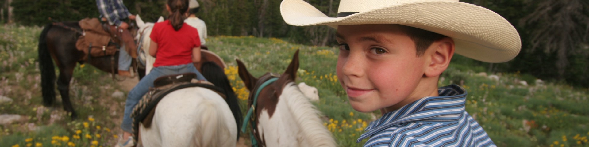
Recreation


A young child stands on the shore of Pinecrest Lake with kayaks and mountains in the distance

Discover an Area by Activity

Select an activity to find an area to visit.

  • Outdoor Safety and Ethics

    A placeholder image

    Make your forest visit a great one by recreating safely and ethically. We have great tips and useful information!

  • Passes & Permits

    A placeholder image

    Whether you're looking to picnic, camp, gather firewood, film, or more, make sure you have your passes and permits ready to go before you head out to the forest!

  • Our Maps

    A placeholder image

    Prepare yourself with digital or printed maps of the forest!

  • Wilderness Information

    A placeholder image

    The Stanislaus has three Wilderness Areas to explore. Free Permits are required to visit these Wilderness Areas. The Carson-Iceberg, the Emigrant, and the Mokelumne Wilderness Areas each offer a distinct and unique experience for camping, backpacking, hiking, fishing, hunting, mountaineering, backcountry-skiing, wildlife-watching, and other non-motorized outdoor pursuits.

Recreation Conditions

The Recreation Conditions Report below displays conditions for all campgrounds, trailheads, and recreation areas on the Stanislaus and are identified by highway corridor location.

The Recreation Conditions Report below is updated based on field-going staff updates. There may be a delay between on the ground conditions and the status listed on the report. For the most up to date information call a Stanislaus National Forest District Office for the area you plan to visit.

Current Recreation Conditions

Area Name Status Area Conditions
Alpine Bypass Trail Open Open Calaveras Ranger District (Hwy 4)
Alpine Ranger Station Closed Closed Calaveras Ranger District (HWY 4)
Andresen Mine Trail Open Open Groveland Ranger District (HWY 120)- Vehicle access may be difficult due to seasonal road closures and snowy conditions. No services available at any trailhead. PACK IT IN, PACK IT OUT, PLEASE! For a list of seasonally closed roads view the Stanislaus National Forest's Motor Vehicle Use Maps. Please use caution while in the Rim Fire burned area.
Arnold Rim Trail Open Open Calaveras Ranger District (HWY 4)
Arnold Rim Trail - Cedar Center Trailhead Open Open Calaveras Ranger District (HWY 4)
Arnold Rim Trail - Logging Museum Trailhead-Arnold Open Open Calaveras Ranger District (HWY 4)
Arnold Rim Trail - San Domingo Southern Trailhead Open Open Calaveras Ranger District (HWY 4)
Arnold Rim Trail - Sheep Ranch Rd & Valley View Dr Open Open Calaveras Ranger District (HWY 4)
Arnold Rim Trail - Sheep Ranch Road & 4N41Y Open Open Calaveras Ranger District (HWY 4)
Arnold Rim Trail - Valley View Drive Trailhead Open Open Calaveras Ranger District (HWY 4)
Arnot Creek TH Unreachable Unreachable Summit Ranger District (HWY 108) 
Asa Lake/ Lower Gardner Meadow Trail Open Open Calaveras Ranger District (Hwy 4)
Backpacker's Walk-In Campground Closed Closed Calaveras Ranger District (HWY 4)
Baker Campground Closed Closed Summit Ranger District (HWY 108) Contact Kennedy Meadows Resort for more information 209.965.3911. October 15, 2024: Closed for the season. 
Bear Valley to Lake Alpine Trail Open Open Calaveras Ranger District (HWY 4)
Beardsley Dam Campground Closed Closed Summit Ranger District (HWY 108) 
Beardsley Day Use Closed Closed Summit Ranger District (HWY 108) Check the  Tri Dam Website for information about water levels. 
Beardsley Reservoir Closed Closed Summit Ranger District (HWY 108) 
Bee Gulch Trail Open Open Calaveras Ranger District (HWY 4)
Bee Gulch Trailhead Open Open Calaveras Ranger District (Hwy 4)
Bell Meadow TH Unreachable Unreachable Summit Ranger District (HWY 108) 
Big Meadow Campground Closed Closed Calaveras Ranger District (HWY 4)
Big Meadow Group Campground Closed Closed Calaveras Ranger District (HWY 4)
Black Springs OHV Area Closed Closed Calaveras Ranger District (HWY 4) 
 
Black Springs OHV Campground Closed Closed Calaveras Ranger District (Hwy 4)
Bloomfield Campground Closed Closed Calaveras Ranger District (HWY 4)
Boulder Flat Campground Closed Closed Summit Ranger District (HWY 108) Contact Dodge Ridge for more information at 209.965.3474, or at the Dodge Ridge webpage
Bower Cave Closed Closed Groveland Ranger District (HWY 120)- Bower Cave is closed. Entering the cave is prohibited.
Brightman Flat Campground Closed Closed Summit Ranger District (HWY 108) Contact Dodge Ridge for more information at 209.965.3474, or at the Dodge Ridge webpage
Bull Run Creek Trail Open Open Calaveras Ranger District (HWY 4)
Bull Run Lake Trail Open Open Calaveras Ranger District (HWY 4)
Calaveras Ranger Station Open Open Calaveras Ranger District (HWY 4) Open.
Camp Irene Trail Open Open Calaveras Ranger District (Hwy 4)
Carlon Day Use Area Open Open Groveland Ranger District (HWY 120)
Carlon Falls Trail Open Open Groveland Ranger District (HWY 120)- Vehicle access may be difficult due to seasonal road closures and snowy conditions. No services available at any trailhead. PACK IT IN, PACK IT OUT, PLEASE! For a list of seasonally closed roads view the Stanislaus National Forest's Motor Vehicle Use Maps. Please use caution while in the Rim Fire burned area.
Carson-Iceberg Wilderness - Highway 108 Access Open Open Summit Ranger District (HWY 108) Wilderness Permits are not required from November 30 - April 15. If you plan a trip into the Wildereness let friends and family know your itinerary. 
Carson-Iceberg Wilderness - Highway 4 Access Open Open Calaveras Ranger District (HWY 4) Wilderness Permits are not required from November 30 - April 15. If you plan a trip into the Wildereness let friends and family know your itinerary. 
Cascade Creek Campground Closed Closed Summit Ranger District (HWY 108) October 15, 2024: Closed for the season. 
Cherry Creek Put-in Closed Closed Groveland Ranger District (HWY 120) Day use only. Wild & Scenic River flows range from 500 cubic feet per second (cfs) to over 12,500 cfs. For current flow information visit dreamflows.com or call 209-962-7825 during regular business hours.
Cherry Lake Open Open Vehicle access may be difficult due to seasonal road closures and snowy conditions. PACK IT IN, PACK IT OUT, PLEASE! For a list of seasonally closed roads view the Stanislaus National Forest's Motor Vehicle Use Maps. Please use caution while in the Rim Fire burned area.
Cherry Lake Boat Launch Open Open ...
Cherry Valley Campground Closed Closed Groveland Ranger District (HWY 120) No water service, so bring potable water. Please note there are no services or marina available at Cherry Lake.
Chickaree Day Use/ Picnic Area Closed Closed Calaveras Ranger District (HWY 4)
China Flat Day Use Closed Closed Summit Ranger District (HWY 108)
Clark Fork Campground Closed Closed Summit Ranger District (HWY 108) Contact Dodge Ridge for more information at 209.965.3474, or at the Dodge Ridge webpage
Clark Fork Horse Camp Closed Closed Summit Ranger District (HWY 108) 
Clark Fork TH Unreachable Unreachable Summit Ranger District (HWY 108) 
Columns of the Giants Closed Closed Summit Ranger District (HWY 108) 
Cottonwood Day Use Closed Closed Summit Ranger District (HWY 108)
County Line TH Unreachable Unreachable Summit Ranger District (HWY 108)  
Coyote Meadows TH Unreachable Unreachable Summit Ranger District (HWY 108) 11/8/2024: Herring Creek is now open. Stanislaus National Forest Order No. STF-16-2024-11, dated October 11, 2024, is hereby terminated.
Crabtree Cross-Country Ski Trailhead Open Open January 15, 2025: The snow is very thin at each of the trailheads, expect icy, pavement first one mile of this trail. Snowshoes aren't needed within a mile of the trailhead, traction devices on boots are recommended. 
Crabtree TH Unreachable Unreachable Summit Ranger District (HWY 108)  
Crandall / Deer Creek Closed Closed Mi Wok Ranger District (HWY 108) 
Dardanelle Campground Closed Closed Summit Ranger District (HWY 108) Contact Dodge Ridge for more information at 209.965.3474, or at the Dodge Ridge webpage
Deadman Campground Closed Closed Summit Ranger District (HWY 108) Contact Kennedy Meadows Resort for more information 209.965.3911. Fall 2025 Update: Closed for the season.
Deer Creek Trail Open Open Calaveras Ranger District (HWY 4)
Deer Valley/ Stevenot Camp Trailhead Closed Closed Calaveras Ranger District (Hwy 4)
Dimond O Campground Closed Closed Groveland Ranger District (HWY 120)
Disaster Creek TH Unreachable Unreachable Summit Ranger District (HWY 108)  
Donnell Reservoir Closed Closed Summit Ranger District (HWY 108) Please help us keep the forest healthy. Please Pack it In, Pack it Out!
Donnell Vista Closed Closed Summit Ranger District (HWY 108)
Douglas Flat Day Use Closed Closed Summit Ranger District (HWY 108) No trash service. Help keep our forest clean and healthy. Please be sure to Pack it In, Pack it Out!
Duck Lake Trail Open Open Calaveras Ranger District (HWY 4)
Eagle Meadow Horse Camp Closed Closed Summit Ranger District (HWY 108) 
Ebbetts Pass National Scenic Byway Closed Closed Calaveras Ranger District (HWY 4) Check Caltrans at dot.ca.gov for current conditions
Elephant Rock Lake Trailhead Open Open Calaveras Ranger District (Hwy 4)
Emigrant Wilderness - Highway 108 Access Open Open Summit Ranger District (HWY 108)  Questions? Call the Summit Ranger Station at 209-965-3434. Wilderness Permits are not required from November 30 - April 15. If you plan a trip into the Wildereness let friends and family know your itinerary. 
Emigrant/ MCCT Trail (Emigrant West Trailhead) Open Open Calaveras Ranger District (HWY 4)
Emigrant/ MCCT Trail (Lakeshore Trailhead) Open Open Calaveras Ranger District (HWY 4)
Emigrant/ MCCT Trail (Mosquito Lakes Trailhead) Open Open Calaveras Ranger District (HWY 4)
Emigrant/ MCCT Trail (Silver Valley Trailhead) Open Open Calaveras Ranger District (HWY 4)
Emigrant/ MCCT Trail (Stanislaus Meadow Trailhead) Open Open Calaveras Ranger District (HWY 4)
Eureka Valley Campground Closed Closed Summit Ranger District (HWY 108) Contact Dodge Ridge for more information at 209.965.3474, or at the Dodge Ridge webpage. This campground will close on 10/22/2023 for the season.
Fence Creek Campground Closed Closed Summit Ranger District (HWY 108) Fall 2024: Fence Creek is closed for the season.  Fence Creek is once again available for use. This campground had been closed since the McCormick Fire of 2017 and the Donnell Fire of 2018. Questions? Call the Summit Ranger Station at 209-965-3434.
Ferretti Non-motorized Trail System Open Open Groveland Ranger District (HWY 120) - The Ferretti Non- Motorized Trail System is a Mountain Bike Destination Trail System and our pilot project in partnership with the Groveland Trailheads. It is located off Ferretti Road in Groveland on 500+ acres within the Groveland Ranger District of the Stanislaus National Forest. Maps are located on this page: https://grovelandtrailheads.org/local-trails/
Fraser Flat Campground Closed Closed Mi Wok Ranger District (HWY 108) Contact Dodge Ridge for more information at 209.965.3474, or at the Dodge Ridge webpage
Fraser Flat Fishing Pier Day Use Closed Closed Mi Wok Ranger District (HWY 108) Contact Dodge Ridge for more information 209.965.3474 Fall 2024: Gate to the Campground is Closed. Walk in only. NO WATER. Bring drinking water. NO TRASH SERVICE. NO TOILETS.
Gardner Meadow Trailhead Open Open Calaveras Ranger District (Hwy 4)
Gianelli TH Unreachable Unreachable Summit Ranger District (HWY 108) 
Gooseberry Cross-Country Ski Trailhead Open Open Summit Ranger District (HWY 108) January 15, 2025: The snow is very thin at each of the trailheads, expect ice, and dirt first one mile of this trail. Snowshoes aren't needed within a mile of the trailhead, traction devices on boots are recommended. 
Groveland Ranger Station Open Open Groveland Ranger District is OPEN to the public. Normal hours are Monday through Saturday, 8:30 am to 4 p.m. Closed weekends and federal holidays.
Hamby Trail Open Open Groveland Ranger District (HWY 120)- Vehicle access may be difficult due to seasonal road closures and snowy conditions. No services available at any trailhead. PACK IT IN, PACK IT OUT, PLEASE! For a list of seasonally closed roads view the Stanislaus National Forest's Motor Vehicle Use Maps. Please use caution while in the Rim Fire burned area.
Heiser Lake Trail Open Open Calaveras Ranger District (HWY 4)
Hermit Valley Open Open Calaveras Ranger District (Hwy 4)
Hermit Valley Campground Closed Closed Calaveras Ranger District (HWY 4)
Herring Creek Campground Closed Closed Summit Ranger District (HWY 108) 
Herring Reservoir Campground Closed Closed Summit Ranger District (HWY 108) October 11, 2024: Area CLOSED due to the Peak Fire. Please refer to Forest Order No. STF-16-2024-11
Highland Creek Trail (Highland Creek Trailhead) Open Open Calaveras Ranger District (HWY 4)
Highland Creek Trail (Silver Valley Trailhead) Open Open Calaveras Ranger District (HWY 4)
Highland Creek Trailhead (at Highland Lakes) Open Open Calaveras Ranger District (Hwy 4)
Highland Lakes Open Open Calaveras Ranger District (HWY 4)
Highland Lakes Campground Closed Closed Calaveras Ranger District (HWY 4) 
Highway 108 Sno-Park Open Open Summit Ranger District (HWY 108)  Check the current snow depth here: Snow Depth Map
Hull Creek / Trout Creek Closed Closed Mi Wok Ranger District (HWY 108) 
Hull Creek Campground Closed Closed Mi Wok Ranger District (HWY 108)
Hunter Creek Closed Closed Mi Wok Ranger District (HWY 108).
Indian Creek Trail Open Open Groveland Ranger District (HWY 120)- Vehicle access may be difficult due to seasonal road closures and snowy conditions. No services available at any trailhead. PACK IT IN, PACK IT OUT, PLEASE! For a list of seasonally closed roads view the Stanislaus National Forest's Motor Vehicle Use Maps. Please use caution while in the Rim Fire burned area.
Inspiration Point Trail Open Open Calaveras Ranger District (HWY 4)
Interface OHV Area Closed Closed Calaveras Ranger District (HWY 4) Closed to wheeled, motorized use from December 15th to April 15th.
Kennedy Meadows TH Unreachable Unreachable Summit Ranger District (HWY 108) 
Kerrick Corral Horse Camp Closed Closed Summit Ranger District (HWY 108) 
Lake Alpine Campground (West Shore) Closed Closed Calaveras Ranger District (HWY 4)
Lake Alpine Recreation Area Closed Closed Calaveras Ranger District (HWY 4)
Lake Alpine SNO-PARK Open Open Calaveras Ranger District (HWY 4) Check current snow depth here: Snow Depth Map 
Lake Valley Trailhead Open Open Calaveras Ranger District (Hwy 4)
Lakeshore Trail Open Open Calaveras Ranger District (HWY 4)
Lakeshore Trail/ Inspiration Point Trailhead Open Open Calaveras Ranger District (HWY 4)
Little Golden Forest Trail Open Open Groveland Ranger District (HWY 120)- Vehicle access may be difficult due to seasonal road closures and snowy conditions. No services available at any trailhead. PACK IT IN, PACK IT OUT, PLEASE! For a list of seasonally closed roads view the Stanislaus National Forest's�Motor Vehicle Use Maps.Interpretive Trail. Self-guided brochures available at Groveland Ranger Station.
Lodgepole Campground Closed Closed Calaveras Ranger District (HWY 4)
Lodgepole Group Campground Closed Closed Calaveras Ranger District (HWY 4)
Lost Claim Campground Closed Closed Groveland Ranger District (HWY 120) 
Lumsden Bridge Campground Temporarily Closed Temporarily Closed Groveland Ranger District (HWY 120) - Closed due to road damage.
Lumsden Campground Temporarily Closed Temporarily Closed Groveland Ranger District (HWY 120) 
Lyons Reservoir (PG&E) Day Use Closed Closed Mi Wok Ranger District (HWY 108) Lyons Reservoir Day Use Area is a PG&E facility.  Closed for the Winter.  
Marmot Day Use/ Picnic Area Closed Closed Calaveras Ranger District (HWY 4)
Meadowview Campground Closed Closed Summit Ranger District (HWY 108) Contact Dodge Ridge for more information at 209.965.3474, or at the Dodge Ridge webpage
Merals Pool Put-In Closed Closed Wild & Scenic River flows range from 150 cubic feet per second (cfs) to over 12,500 cfs. For current flow information visit dreamflows.com or call 209-962-7825 during regular business hours.
Mi Wok Ranger Station Closed Closed Mi-Wok Ranger Station (HWY 108) This is an administrative site only and the Front Desk is CLOSED. Please visit Summit Ranger Station at Pinecrest or the Supervisor's Office in Sonora for information and assistance.
Middle Fork Day Use Area Closed Closed Groveland Ranger District (HWY 120) No overnight camping. 
Milk Ranch Meadow Trail Open Open Calaveras Ranger District (HWY 4)
Mill Creek Campground Closed Closed Summit Ranger District (HWY 108) October 15, 2024: Closed for the season. 
Mokelumne Coast to Crest Trail (MCCT) Open Open Calaveras Ranger District (HWY 4)
Mokelumne Wilderness Open Open Calaveras Ranger District (HWY 4)
Moore Creek Campground Closed Closed Calaveras Ranger District (HWY 4) 
Mosquito Lakes Open Open Calaveras Ranger District (HWY 4)
Mosquito Lakes Campground Closed Closed Calaveras Ranger District (HWY 4)
Mosquito Lakes Trailhead Open Open Calaveras Ranger District (HWY 4)
Mosquito Lakes to Pacific Valley/ MCCT Trail Open Open Calaveras Ranger District (HWY 4)
Mosquito Lks to PacificV/MCCT (Mosq Lks Trailhead) Open Open Calaveras Ranger District (HWY 4)
Mosquito Lks to PacificV/MCCT (PacificV Trailhead) Open Open Calaveras Ranger District (HWY 4)
Niagara Creek Campground Closed Closed Summit Ranger District (HWY 108) Fall 2024: This campground is closed for the season.
Niagara OHV Campground Closed Closed Summit Ranger District (HWY 108)
North Fork Day Use Closed Closed Mi Wok Ranger District (HWY 108) 
North Fork Stanislaus River Open Open Calaveras Ranger District (HWY 4)
Osborne Ridge Trail Open Open Calaveras Ranger District (HWY 4)
Pacific Valley Campground Closed Closed Calaveras Ranger District (HWY 4)
Pacific Valley Trailhead Open Open Calaveras Ranger District (HWY 4)
Pigeon Flat Campground Closed Closed Summit Ranger District (HWY 108) Contact Dodge Ridge for more information at 209.965.3474, or at the Dodge Ridge webpageFall 2024: Pack it in Pack it out. No Garbage Service. No Water.
Pine Marten Campground Closed Closed Calaveras Ranger District (HWY 4)
Pine Valley Horse Camp Closed Closed Summit Ranger District (HWY 108) 
Pinecrest Campground Closed Closed Summit Ranger District (HWY 108) Reservations are required. Contact Dodge Ridge for more information at 209.965.3474, or at the Dodge Ridge webpage
Pinecrest Lake Open Open Summit Ranger District (HWY 108) 
Pinecrest Lake Day Use Open Open Summit Ranger District (HWY 108) Plan ahead for alternate location to recreate if parking lots are full and day use area is crowded. Parking will be strictly enforced.
Pinecrest Lake National Recreation Trail Open Open Summit Ranger District (HWY 108)  Pack it in, Pack it out. Respect the private cabins. The vault toilet on the backside of the lake is CLOSED. 
Pines Campground Open Open Groveland Ranger District (HWY 120) 
Pines Group Campground Open Open Reservation can be made at www.recreation.gov or by calling (877) 444-6777.
Pioneer Trail Group Campground Open Open Summit Ranger District (HWY 108) Reservations required. Contact Dodge Ridge for more information at 209.965.3474, or at the Dodge Ridge webpage.  Fall 2024: Pioneer Campground will reopen for winter camping on 11/01/2024. Pioneer Trail is also open for first-come-first-serve Winter Camping through Mid-April. Winter camping is free for groups of 15 or less. Please send an email to info@dodgeridge.com to inform our staff of your planned arrival date. Water is not available during the winter camping months. One vault toilet is available in winter. For groups of 16 or more, the fee is $1 per person, per night (ie. a group of 16 people would pay $16/night and then $1/person/night for each additional person). Payments can be made in the administration office just up Dodge Ridge Road from the campground at Dodge Ridge Ski Resort.
Preston Falls Trail Open Open Groveland Ranger District (HWY 120)-Vehicle access may be difficult due to seasonal road closures and snowy conditions. No services available at any trailhead. PACK IT IN, PACK IT OUT, PLEASE! For a list of seasonally closed roads view the Stanislaus National Forest Motor Vehicle Use Maps. Please use caution while in the Rim Fire burned area.
Rainbow Pool Day Use Area Closed Closed Groveland Ranger District (HWY 120) No alcoholic beverages or overnight camping. No garbage service; pack it in, pack it out. 
Rim of the World Vista Open Open Groveland Ranger District (HWY 120) No restrooms or services available.
River Ranch - Hacienda Campground Closed Closed Mi Wok Ranger District (HWY 108). River Ranch Campground is part private, part public. The private sites on River Ranch Campground; the public sites are in Hacienda Campground (adjoined to and managed by River Ranch). 
Riverside Day Use Open Open Mi Wok Ranger District (HWY 108) 
Rock Lake Trail Open Open Calaveras Ranger District (Hwy 4)
Rock Lake Trail (from Silver Valley Trailhead) Open Open Calaveras Ranger District (Hwy 4)
Round Valley SNO-PARK Open Open Calaveras Ranger District (HWY 4) Check the current snow depth here: Snow Depth Map
Sand Bar Flat Campground Closed Closed Mi Wok Ranger District (HWY 108).  Fall 2025 Update: Starting October 15th this campground will no longer have services or fees. NO Fees - NO Services. Pack it in - Pack it out. Bring your own water. Questions? Call the Summit Ranger Station at 209-965-3434.
Sand Flat Campground Closed Closed Summit Ranger District (HWY 108) Contact Dodge Ridge for more information at 209.965.3474, or at the Dodge Ridge webpage
Sand Flat Campground (4wd only) Closed Closed Calaveras Ranger District (HWY 4)
Sandy Meadow Trail Open Open Calaveras Ranger District (Hwy 4)
Sandy Meadow Trailhead Open Open Calaveras Ranger District (Hwy 4)
Seven Pines TH Unreachable Unreachable Summit Ranger District (HWY 108) 
Shadow of the Mi-Wok Open Open Summit Ranger District (HWY 108) 
Silver Valley Campground Closed Closed Calaveras Ranger District (HWY 4)
Silver Valley Trailhead Open Open Calaveras Ranger District (Hwy 4)
Silvertip Campground Closed Closed Calaveras Ranger District (HWY 4)
Slick Rock Jeep Trail Closed Closed Calaveras Ranger District (HWY 4) Closed to wheeled, motorized use from December 15th to April 15th. 
Sonora Pass TH Unreachable Unreachable Summit Ranger District (HWY 108)  
Sourgrass Day Use Open Open Calaveras Ranger District (HWY 4)
Sourgrass Recreation Area Open Open Calaveras Ranger District (HWY 4)
South Fork Campground Temporarily Closed Temporarily Closed Groveland Ranger District (HWY 120)
Spicer Reservoir Open Open Calaveras Ranger District (HWY 4) 
Spicer Reservoir Campground Closed Closed Calaveras Ranger District (HWY 4)
Spicer Reservoir Group Campground Closed Closed Calaveras Ranger District (HWY 4)
Spicer Reservoir Picnic Area Closed Closed Calaveras Ranger District (HWY 4)
Spicer SNO-PARK Open Open Calaveras Ranger District (HWY 4) Check the current snow depth here: Snow Depth Map
Spicer Sand Flat Trailhead (at Spicer Reservoir) Open Open Calaveras Ranger District (HWY 4)
St. Marys Pass TH Unreachable Unreachable Summit Ranger District (HWY 108) 
Stanislaus Meadow Trailhead Open Open Calaveras Ranger District (HWY 4)
Stanislaus River Campground Closed Closed Calaveras Ranger District (HWY 4)
Sugar Pine Railway - Strawberry to Fraser Open Open Summit Ranger District (HWY 108) 
Summit Lake/ Mud Lake Trailhead Open Open Calaveras Ranger District (HWY 4)
Summit Ranger Station Open Open
Sweetwater Campground Open Open Groveland Ranger District (HWY 120)
TeleLi puLaya (Black Oak) Campground Closed Closed Summit Ranger District (HWY 108) 
Trail of the Ancient Dwarfs Closed Closed Summit Ranger Station (Hwy 108) October 2024: This trail has recently been rehabilited. The wayfinding signs are not in place yet, which means the trailhead is unmarked. If you have questions please contact the Summit Ranger Station, 209-965-3434.
Trail of the Gargoyles Closed Closed Summit Ranger District (HWY 108) 11/8/2024: Herring Creek is now open. Stanislaus National Forest Order No. STF-16-2024-11, dated October 11, 2024, is hereby terminated.
Trumbull Peak Special Interest Area Closed Closed Groveland Ranger District (HWY 120) No public motorized access from Dec. 15 to April 15 due to seasonal road closures.
Tryon Meadow Trailhead Open Open Calaveras Ranger District (Hwy 4)
Tuolumne River Canyon Trail Open Open Groveland Ranger District (HWY 120) Vehicle access may be difficult due to seasonal road closures and snowy conditions. No services available at any trailhead. PACK IT IN, PACK IT OUT, PLEASE! For a list of seasonally closed roads view the Stanislaus National Forest Motor Vehicle Use Maps. Please use caution while in the Rim Fire burned area.
Tuolumne Wild and Scenic River Open Open Groveland Ranger District (HWY 120) Day use only. Wild & Scenic River flows range from 500 cubic feet per second (cfs) to over 12,500 cfs. For current flow information visit dreamflows.com or call 209-962-7825 during regular business hours.
Union East Campground Closed Closed Calaveras Ranger District (Hwy 4)
Union East Campground to Elephant Rock Lake Trail Open Open Calaveras Ranger District (Hwy 4)
Union West Campground Closed Closed Calaveras Ranger District (Hwy 4)
Upper Gardner Meadow Trail Open Open Calaveras Ranger District (Hwy 4)
Utica Reservoir Campgrounds Closed Closed Calaveras Ranger District (HWY 4)
Utica/Union Reservoirs Open Open Calaveras Ranger District (HWY 4) (Not the campgrounds)
Wakalu Hep Yo (Wild River) Campground Closed Closed Calaveras Ranger District (HWY 4) 
Waterhouse TH Unreachable Unreachable Summit Ranger District (HWY 108) 11/8/2024: Herring Creek is now open. Stanislaus National Forest Order No. STF-16-2024-11, dated October 11, 2024, is hereby terminated.
West Side Railroad Grade Open Open Mi Wok Ranger District (HWY 108). NO DRINKING WATER available after parking area. Closed to motorized vehicles. Excellent spring wildflowers but hot temperatures. Bring extra drinking water.
Wheats Meadow TH Unreachable Unreachable Summit Ranger District (HWY 108) 
Wheats Meadow Trailhead (Spicer Dam Side)(CIW) Open Open
Wheats Meadow Trailhead (Spicer Dam side) Open Open Calaveras Ranger District (HWY 4)
Wheeler Ridge/ Wheeler Lake Trail Open Open Calaveras Ranger District (HWY 4)
Woodchuck Basin Trailhead Open Open Calaveras Ranger District (HWY 4)

Spotlights

Tuolumne Wild and Scenic River

Rafter executing a rapid on the Tuolumne River Visitors rafting down the Tuolumne river surrounded by mountains.
Access to the Tuolumne Wild and Scenic River via Lumsden Road is closed, to provide for public safety, under Forest Order No. STF-16-2023-04 due to road damage caused by the 2023 atmospheric events. Access is limited to FSR 1S01, (South Fork Rd) – walk in only. Please contact the Groveland RD for additional information.

Considered to be some of the best "All Around" whitewater in the nation, the Main Tuolumne offers 16-18 miles of Class 4-5 rapids. Side streams such as the Clavey River, Big Creek, and the North Fork of the Tuolumne River offers side hikes, fishing holes, and warm swimming pools during the summer months. 

Main Tuolumne - The Main Tuolumne is a challenging and enjoyable Class 4+, 18-mile whitewater run through the foothills of the Sierra Nevada. This section has some demanding rapids spaced at close intervals. At above 4,000 cubic feet per second (CFS). The river becomes more powerful and recovery more difficult. The biggest rapid, the Clavey, can be walked around or portaged. Camping is available at several sites along the way. Reservoir release summer flows generally arrive at Merals Pool launch mid-morning and drop to less than 300cfs after noon. A three-day trip allows boaters to enjoy the canyon and its tributaries. River flow graphs can be found at http://dreamflows.com.

During spring runoff, flows above 5,000 CFS make the Main Tuolumne a class 5 experience. The takeout at Wards Ferry Bridge is difficult and dangerous at all times. Stay hydrated and exercise caution carrying boats up the bridge.

Cherry Creek - The 9-mile class 5+ Cherry Creek/Tuolumne run is one of the most challenging commercial runs in the world. Yet the nature of the rock in the riverbed allows expert boaters an exhilarating experience. It has 15 class 5 rapids. Two 5+ rapids (Flat Rock Falls and Lumsden Falls) are recommended portage. Generally, it is run below 2,000 CFS. Boaters who attempt this run are well-advised to go with experts that have run the river before. As with the Main T, a permit is required to run the river. Permits are available at www.recreation.gov 

Separate permits are required from Cherry-Creek to Merals Pool and from Merals Pool to Wards Ferry Bridge.

Merals Pool Put-In

The Main Tuolumne is a challenging and enjoyable Class 4+, 18-mile whitewater run through the foothills of the Sierra Nevada. This section has some demanding rapids spaced at close intervals. At above 4,000 cubic feet per second (CFS). The river becomes more powerful and recovery more difficult. The biggest rapid, the Clavey, can be walked around or portaged. Camping is available at several sites along the way. Reservoir release summer flows generally arrive at Merals Pool launch mid-morning and drop to less than 300cfs after noon. A three-day trip allows boaters to enjoy the canyon and its tributaries. 

Trail of the Ancient Dwarfs

Toadstool Rock

The Trail of the Ancient Dwarfs is a magical place where the forces of nature and humans merge. Natures forces have shaped this landscape, the shape of the rocks, soils, and trees are a result of the effects of millions of years of geologic forces, weather, and erosion. Humans too shaped this landscape. One can find evidence in the rocks, and soils that the Me-wuk people have lived in this area for over 15,000 years. Like a lightening bolt , everything changed. People came from all over the world and changed this landscape even further. Here on this trail you will see evidence of that, the Old Mono Highway which served as a route for wagons first then cars was carved into the mountain. As you walk take notice of both nature and human influence on the landscape.

This trail starts on the other side of Niagara Creek. Please cross the creek by foot. Be careful—if the creek is too high do not cross. NOTE: The old bridge has been condemned it is NOT safe to cross. The interpretive trail starts after a short walk to the start. The walk to the start of the is 0.42 miles and the interpretive trail is 0.46 miles. Round trip is about 2 miles.

Please download the Interpretive Guide or pick up a copy at the Summit Ranger Station. Check out this video on how the trail was rehabilitated! Thank you the CSERC, local volunteers, and the Recreation Staff from the Summit Ranger District for bringing this trail back to life. 

Cherry Creek Put-in

The 9-mile class 5+ Cherry Creek/Tuolumne run is one of the most challenging commercial runs in the world. Yet the nature of the rock in the riverbed allows expert boaters an exhilarating experience. It has 15 class 5 rapids (one 5+ rapid with recommended portage). Generally, it is run below 2,000 CFS. Boaters who attempt this run are well-advised to go with experts that have run the river before. As with the Main T, permits are required to float this section. Available at Recreation.gov 


Recreation Areas

Featured Events