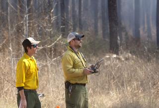
Drones change the way forest fires are managed

TEXAS—Leaps in uncrewed aircraft systems, or drones, are changing the way fire is managed in America’s forests.
“Drones are our eyes in the sky. We use them to conduct prescribed fires, suppress wildfire, survey forests, assess damages after a storm and generally manage forests,” said Robert Dogden, fire management officer on the Davy Crockett National Forest in Texas. “Drones are an important tool when used in the right situations and environments.”
Dogden says that drones help the USDA Forest Service Southern Region get more done. In fact, one out of every 10 acres treated with prescribed fire is thanks to drones and the people who fly them.
“We can send drones into arduous terrain—or places with low visibility,” said Dogden, noting that drones also help keep Forest Service employees safe by keeping them away from active firelines.
So far this year, drones have flown more than 300 hours in the Southern Region; that includes 55 hours on active wildfires in Mississippi and Texas. This is a significant amount of time drones were in the air during the 2023 fire season.
The Southern Region is home to the most accomplished fuels program in the country; the region also is one of the leaders in using uncrewed aerial systems for forest management. The region boasts seven pilots with the highest level of training: those who can start prescribed fires with a drone—a practice known as aerial ignition.
Drone pilots who conduct aerial ignition complete training that can span two years and includes: Federal Aviation Administration remote pilot license, interagency aviation training remote pilot courses, incident operations, a series of courses from the National Wildfire Coordinating Group and, finally, the Interagency Aerial Ignition Academy.
“The technology of uncrewed aerial systems is advancing rapidly, which in turn increases opportunities for how we manage southern forests,” said Shardul Raval, who directs fire and aviation management program for the region. “Individuals are continually trained on new technology as it becomes available, allowing the region to use the latest in drone technology to perform work safely and efficiently.”


