U.S. flag

An official website of the United States government

Trail Management Toolbox - Terms


Below is the agency’s online dictionary of common trail terminology, with definitions, photos and illustrations.  

These terms may appear in various trail publications and Forest Service policy. If there is a conflict in the definition, Forest Service policy is the authority. Many of the diagrams or illustrations are adapted from engineered plans featured on the Plans for Trail and Trail Bridge Structures web page.

For More Information

Please contact Forest Service Trail Management if you have questions or comments.


A hiking trail that meets the technical design requirements described in the Forest Service Trail Accessibility Guidelines (PDF, 1.83 MB).

A trail with a firm and uniform surface winds through trees and brush.
A trail with a firm and uniform surface winds through trees and brush. (USDA Forest Service photo by Scott Johnson, Sequoia National Forest, California.)

A trail with design characteristics that allow people with mobility disabilities to use them, typically with the assistance of adaptive riding equipment.

Two people smile as they ride a mountain bike and a motorized adaptive device on a motorized route.
Lake Tahoe Basin Management Unit, California. (USDA Forest Service photo by Garrett Villanueva)

The section of trail on either end of a structure that rise in a ramp or steps 2-8 percent to meet the structure deck to prevent water from flowing and depositing soil and debris onto the bridge.

Wooden bridge with steel mesh on wooden approaches.
Carson National Forest, New Mexico. (USDA Forest Service photo by Kerry Wood)

The practice of "hardening" the trail tread with large rocks laid flat that create an exceptionally durable tread that resists erosion, compaction, and displacement.

Trail with rocks armoring the trail tread.
Carson National Forest, New Mexico. (USDA Forest Service photo by Kerry Wood)

Axe with two symmetrically opposed cutting edges. One edge is maintained at razor sharpness. The other edge is usually duller and used to chop around rocks or in soil. Mark the duller edge with a spot of paint.

A double-bit axe laying on top of a white paper background.
A double-bit axe. (USDA Forest Service photo by Laurent Deviche)

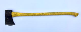
Axe with a single cutting blade and handle that is used for felling and splitting.

A single-bit axe laying a light blue background.
A single-bit axe. (USDA Forest Service photo by Matt Able)

The excavated area of the hillside above the tread surface.

A trail midslope with an excavated backslope.
A trail midslope with an excavated backslope. (USDA photo by Scott Johnson, Boise National Forest, Idaho)
A labeled drawing of three common backslope ratios, 1:1, 2:1, and 1:3.
A Labeled drawing of three common backslope ratios, 1:1, 2:1, and 1:3. (USDA Forest Service illustration)

The amount that a vertically stacked structure (typically a wall) leans back towards whatever it’s holding up, often referred to as a ratio between the amount of rise and the amount of run.

A labeled illustration of a cairn made from stacked stones.
A labeled illustration of a cairn made from stacked stones. (USDA Forest Service illustration)

The section of the trail tread cut into the hillside that provides a firm and stable surface.

An illustration of a trail fully cut into a hillside with a 5 percent outslope tread label.
An illustration of a full-bench construction. (USDA Forest Service illustration)

The mound of soil that typically forms on the outside edge of the tread as water and trail users displace and compact the soil.

A labeled illustration of a person standing on a trail with slough deposited on the uphill side of the trail and a berm formed on the downhill side of the trail.
A labeled illustration of a person standing on a trail with slough deposited on the uphill side of the trail and a berm formed on the downhill side of the trail. (USDA Forest Service illustration)

The shape and angle of the cutting edge of a blade that influences the type of cut and how long the blade will remain sharp after use.

An illustration showing the correct and incorrect blade bevels for most trail tools.
Illustration showing the correct (flat bevel and convex bevel) and incorrect (concave bevel) blade bevels for most trail tools. (USDA Forest Service illustration).

A small triangle typically made from plastic or metal affixed to trees or posts to mark the trail route.

A labeled illustration of marker tags affixed to a tree and a short post.
A labeled illustration of marker tags affixed to a tree and to a short post. (USDA Forest Service illustration)

A typically wooden structure less than 7 ft tall with railing, decking, posts, that elevates the tread above seasonally or perennially saturated soil.

The substructure of an elevated boardwalk showing posts attached with cross beams.
Substructure of an elevated boardwalk. (USDA Forest Service photo by Laurent Deviche, Tongass National Forest, Alaska)
A labeled drawing of an elevated boardwalk, including measurements.
A labeled illustration of an elevated boardwalk structure. (USDA Forest Service illustration)

The basic structure is a plank tread surface resting directly on sills, cribbing, or piles. Note the name for this structure varies.

A labeled illustration of a bog bridge structure on timber, log, and stacked lumber.
A labeled illustration of a bog bridge structure on timber, log, and stacked lumber. (USDA Forest Service illustration)

A trail bridge is a structure, erected over a depression or obstruction such as a body of water, a road, a trail, or a railroad that provides a continuous pathway and that has a deck for carrying traffic or other loads. They range from a simple foot bridge to multi-span, suspended, and truss structures.

A labeled illustration of a simple wooden trail bridge with a railing system, bridge, and a cutaway on one side showing the sill or abutment.
A labeled illustration of a simple wooden trail bridge with a railing system, bridge, and a cutaway on one side showing the sill or abutment. (USDA Forest Service illustration)

Cutting out a cross-section of a fallen tree to make smaller, more manageable sections.

Three illustrations showing the straight cut, compound cut, and offset cut.
Three illustrations showing the straight cut, compound cut, and offset cut. (USDA Forest Service illustrations)

Curb and bull rail are two names for a barrier along the sides of a boardwalk or puncheon.

Two labeled illustrations of the end and side view of boardwalk curbing.
Two labeled illustrations of the end and side view of boardwalk curbing. (USDA Forest Service illustration)

A stacked rock structure used to mark less-developed trails in open areas where low visibility or snow cover makes it difficult to follow the tread or where the tread is rocky and indistinct.

A labeled illustration of a cairn made from stacked stones.
A labeled illustration of a cairn made from stacked stones. (USDA Forest Service illustration)

A log or rock and earthen structure that elevates the trail tread above the seasonally wet areas. It is also considered a turnpike without ditches.

A labeled illustration of a trail causeway.
A labeled illustration of a trail causeway. (USDA Forest Service illustration)

Toolhead that attaches to the chainsaw bar and uses cutting blades that are rotated by the chainsaw chain for debarking, planning, jointing, and notching logs.

A chainsaw debarking attachment not connected to a chainsaw.
A chainsaw debarking attachment not connected to a chainsaw. (USDA Forest Service photo by Tim Farris)

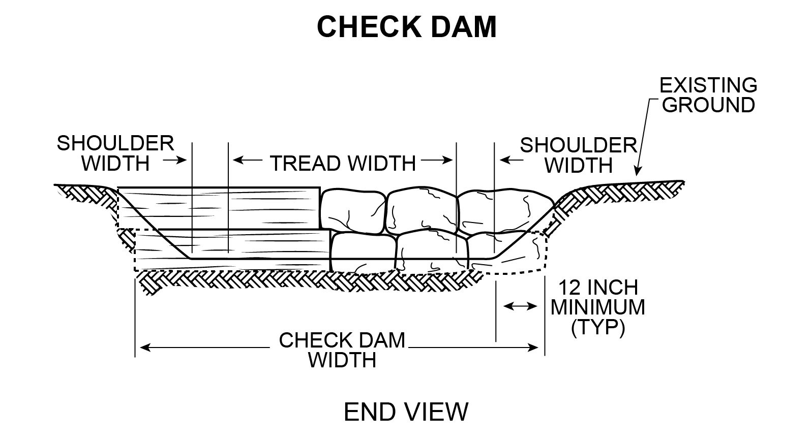
Earthen, log, or rock retainment structure built perpendicular to the trail that slows water velocity forcing it to deposit sediment.

An illustration of a check dam made with embedded timbers and rocks.
An illustration of a check dam made with embedded timbers and rocks. (USDA Forest Service illustration)

The height of the clearing limit within the trail corridor measured vertically from the trail tread.

A labeled illustration of clearing limits in timber.
A labeled illustration of clearing limits in timber. (USDA Forest Service illustration)

The area over and beside the trail tread within the trail corridor that is cleared of trees, limbs, and other obstructions.

A labeled illustration of a trail through trees with a dotted rectangle indicating the clearing height and width.
A labeled illustration of a trail through trees with a dotted rectangle indicating the clearing height and width. (USDA Forest Service illustration)
A labeled illustration of clearing limits in timber.
A labeled illustration of clearing limits in timber. (USDA Forest Service illustration)
A labeled illustration of a hiker and equestrian rider on the same trail with different clearing dimensions.
A labeled illustration of a hiker and equestrian rider on the same trail with different clearing dimensions. (USDA Forest Service illustration)

The width of the clearing limit within the trail corridor measured perpendicular to the trail.

A labeled illustration of clearing limits in timber.
A labeled illustration of clearing limits in timber. (USDA Forest Service illustration)

A reverse in direction of the trail grade without a level landing that is used to change elevation on a steep slope.

A trail in a forest gaining elevation as the trail turns.
A climbing turn in a forest trail. (USDA photo by Scott Johnson, Wayne National Forest)
A labeled illustration of a the top and side view of a climbing turn.
A labeled illustration of a the top and side view of a climbing turn. (USDA Forest Service illustration)

A handheld device, also called a “clino”, used to measure the grade (percent) or angle (degree) of a trail segment or hillside.

A clinometer and cord laying on a table.
Clinometer and cord laying on a table. (USDA Forest Service photo by Kerry Wood)
A labeled illustration of a clinometer.
A labeled illustration of a clinometer. (USDA Forest Service illustration)

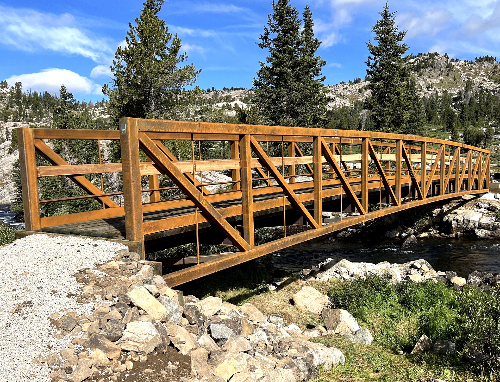
A trail bridge made of a wood, metal, or other material that uses trusses, suspension or other multiple spans that is appropriate for fully developed trails (class 5). It requires in-depth training and certification to inspect and should be inspected every five years.
 

A metal bridge with railing crossing a stream in a single span that is more than 20 ft (6 m).
A metal bridge with railing crossing a stream in a single span that is more than 20 ft (6 m). (USDA Forest Service photo by Jay Sammer, Bridger-Teton National Forest, Wyoming)

The result of trail users or wildlife using the outside edge of a trail on a hillside and migrating the trail farther down the slope, narrowing the tread.

An illustration of a horse and rider walk on a portion of trail narrowed by slough.
An illustration of a horse and rider walking on a portion of trail narrowed by slough. (USDA Forest Service illustration)
An illustration of a large rock embedded on the outside edge of a trail on a hillside.
An illustration of a large rock embedded on the outside edge of a trail on a hillside. (USDA Forest Service illustration)

A wooden retaining wall made from logs or dimensional lumber. The structure can support the trail tread or hold fill material back from the tread.

A trail worker stands inside layers making up a large crib wall that is being constructed.
A trail worker stands inside layers making up a large crib wall that is being constructed. (USDA Forest Service photo by Nathaniel Brodie, Columbia River Gorge National Recreation Area)
Labeled illustration of the front and side view of a crib wall.
A labeled illustration of the front and side view of a crib wall. (USDA Forest Service illustration)

The ratio of vertical rise to trail width when measured from one trail edge to another perpendicular to the direction of travel.

An illustration of two techniques to adjust the cross slope when a trail structure foundation is sinking into the ground.
An illustration of two techniques to adjust the cross slope when a trail structure foundation is sinking into the ground. (USDA Forest Service Illustration)

A two-person saw with a stiff and heavier blade that has a straight-shaped back that is used for bucking or cutting logs on the ground.
 

A crosscut saw or bucking saw without handles attached.
A crosscut saw or bucking saw without handles attached. (USDA Forest Service photo by Kerry Wood)

A two-person saw with a light and flexible blade that has a concave-shaped back that is used for felling standing trees.
 

A felling saw with left and right handles attached laying on a floor.
A felling saw with left and right handles attached. (USDA Forest Service photo by Kerry Wood)

A crosscut saw with a handle on one end that requires only one sawyer.
 

A one-person crosscut saw with single handle.
A one-person crosscut saw. (USDA Forest Service photo by Matt Able)

Bottomless arch culverts require less vertical space and has a natural streambed bottom that is preferred for aquatic organism passage.  Work with hydrologists to determine the best type and size of culvert to fit your needs.
 

A dirt trail passing over a plastic bottomless arc culvert.
A dirt trail passing over a plastic bottomless arc culvert. (USDA Forest Service photo by Scott Johnson, Boise National Forest, Idaho)

A hollow structure made of large rocks placed in the ground that allows low to moderate flows to pass under the trail.

A dirt trail crossing a stream with large rocks creating a culvert that allows water to pass under the trail.
A dirt trail crossing a stream with large rocks creating a culvert that allows water to pass under the trail. (USDA Forest Service photo by Garrett Villanueva, Lake Tahoe Basin Management Unit, California)
A labeled illustration of the top view of a rock culvert placed under a trail and showing an excavated settling basin upstream.
A labeled illustration of the top view of a rock culvert placed under a trail and showing an excavated settling basin upstream. (USDA Forest Service illustration)

A linear feature of wood, concrete, or stone placed or affixed on the sides of a trail. The curb can rest on the trail tread or elevated a few inches on scupper blocks.

Curbing with scupper blocks on a trail bridge.
Curbing with scupper blocks on a trail bridge. (USDA Forest Service photo by Cheryl Ladota)
A labeled illustration of a short boardwalk with a railing system of posts and rails.
A labeled illustration of a short boardwalk with a railing system of posts and rails. (USDA Forest Service illustration)

A channel of appropriate size and grade that facilitates the unobstructed flow of water and transported sediment that extends far enough away and downhill from the trail where water can continue to flow down the natural hillslope without being able to return to the trail tread in another location. In an appropriately shaped channel, the flow of water and sediment will be adequate to "self-clean" the drain without undercutting the trail.
 

A modified climbing turn with rocks in the tread that provide inside drainage before the turn.
A modified climbing turn with rocks in the tread that provide inside drainage before the turn. (USDA Forest Service photo by Adam Carroll, Pike-San Isabel National Forests, Colorado)

Demolition, dismantling, removal, obliteration and/or disposal of a deteriorated or otherwise unneeded asset or component, including necessary cleanup work.

A trail that has been scarified and overlain with logs, debris, and other material to disguise the old tread.
A trail that has been scarified and overlain with logs, debris, and other material to disguise the old tread. (USDA Forest Service photo by Scott Johnson, Pike-San Isabel National Forests, Colorado)

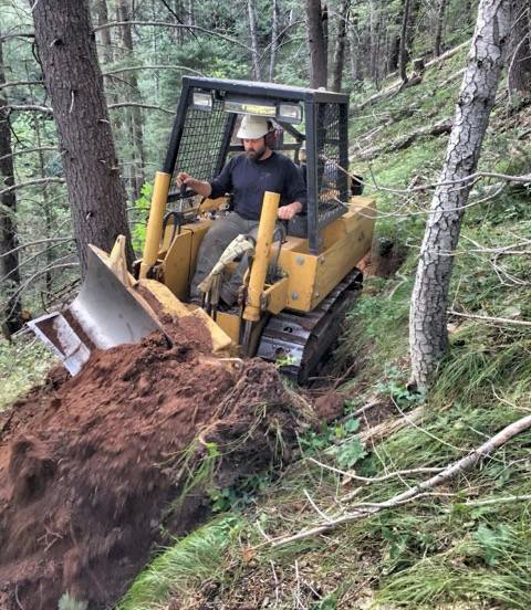
The trail dozer is commonly used to cut in full-bench trails, during heavy maintenance to repair trail tread and reconstruct rolling dips, and during decommissioning to reshape and naturalize the old trail tread.
 

A trail dozer in operation by a single person, moving dirt with a small dozer blade.
A trail dozer in operation by a single person, moving dirt with a small dozer blade. (USDA Forest Service photo by Scott Johnson, Boise National Forest, Idaho)

An earthen structure with a low point that directs the flow of water with enough velocity to wash sediment out of the drain, keeping it clear and requiring less frequent maintenance. The drainage outslope should be maintained greater than 5 percent to self clean.

A labeled illustration divided in half of a constructed rolling grade dip with a drainage basin and a sediment basin.
A labeled illustration of a properly constructed rolling dip with a drainage basin and a sediment basin. (USDA Forest Service illustration)

A hand-held tool with a blade affixed between two handles this is designed to peel dry logs.
 

A drawknife, with a long blade and wood handles on either side situated in a way that the blade is drawn towards the user.
A drawknife. (USDA Forest Service photo by Matt Able)

A length of rebar or steel pipe driven through predrilled holes in a timber or log and into the ground to the secure the structure to the ground. Drift pins should be driven into the ground at least 18 inches and be countersunk into the structure to avoid protruding.

An illustration of a hand holding a piece of rebar through a section of pipe, and striking a rebar drift pin to drive it through wood until countersunk.
An illustration showing the proper method to countersink a rebar drift pin. (USDA Forest Service illustration)

Leaves, sticks, and other organic material that accumulate above the mineral soil layer.

An illustration of a check dam made with embedded timbers and rocks.
An illustration of a check dam made with embedded timbers and rocks with organic debris ("duff") accumulated between the checks. (USDA Forest Service illustration)

Removal of soil by water, wind, other natural forces and trail users.

A steep dirt trail with ruts and obstacles.
A steep dirt trail with ruts and obstacles. (USDA Forest Service photo by Scott Johnson)

The path that follows the most direct route downhill.

A dirt trail that is deeply rutted and routed directly uphill.
A dirt trail deeply rutted and routed directly uphill. (USDA Forest Service photo by Scott Johnson)

Files come in single or double, curved or rasp cuts. Single-cut files have one series of parallel teeth angled 60 to 80 degrees from the edge; they are used for finishing work. Double-cut files have two series of parallel teeth set at a 45-degree angle to each other; they are used for restoring shape. Curved and rasp files have elevated teeth that are used for shaping metal and wood respectively.
 

A single file with a cloth knuckle guard.
A single file with a cloth knuckle guard. (USDA Forest Service photo by Kerry Wood)

The material excavated from a bench cut into a hillside that is compacted to create the outside of the trail tread.

A labeled illustration of half a trail bed excavated from the hillside and the other half made from compacted fill material, called the fillslope.
A labeled illustration of half a trail bed excavated from the hillside and the other half made from compacted fill material, called the fillslope. (USDA Forest Service illustration)

A surface that is not noticeably distorted or compressed during the seasons for which it is managed, under normally occurring weather conditions, by the passage of a device that simulates a trail user in a wheelchair.

A trail with a firm and uniform surface winds through trees and brush.
A trail with a firm and uniform surface winds through trees and brush. (USDA Forest Service photo by Scott Johnson, Sequoia National Forest, California.)

A method of constructing a grade reversal within the existing trailway that elevates or lowers the trail tread resulting in a forced uphill grade to force water off the trail.

Two side-by-side images of the same trail with a minor reroute curving uphill to avoid the strait fall line.
Two side-by-side images of the same trail with a minor reroute curving uphill to avoid the fall line. (USDA Forest Service photo by Kerry Wood, Cibola National Forest, New Mexico)

Shallow stream crossing for low and moderate flows that provide users with solid, level footing or driving surface at a consistent depth from one bank to the other without blocking passage for fish and other aquatic organisms.

A labeled illustration of a trail crossing a stream with stepping stones, armoring, and uphill labels on either side of the stream.
A labeled illustration of a trail crossing a stream with stepping stones, armoring, and uphill labels on either side of the stream. (USDA Forest Service illustration)

Describes a type of trail construction where the full width of the trail is excavated from the hillside to create the trail tread.

An illustration of a trail fully cut into a hillside with a 5 percent outslope tread label.
An illustration of a full-bench construction. (USDA Forest Service illustration)

Wire mesh containers filled with angular rock that serve as retaining walls, foundations, and other structures.

An extensive gabion basket structure supporting trail tread at the bottom of a cliff face.
An extensive gabion basket structure supporting trail tread at the bottom of a cliff face. (USDA Forest Service photo by Nathan Emer, Ashley National Forest)

Grade reversals (a.k.a. grade dips, terrain dips, break in grade, undulations, or swales) are areas along a trail where the trail grade reverses or changes in the opposite direction—up or down. The reversal or rise (crest) and fall (dip) of the trail are repeated as it traverses the hillside. The crest must be tall enough to divert anticipated water flows off the trail while not creating a trail jump.

A contour trail with text overlay indicating crests of grade reversals and a rise over run triangle.
A contour trail with text overlay indicating crests of grade reversals and a rise over run triangle. (USDA Forest Service graphic by Kerry Wood, Cibola National Forest, New Mexico)

A grubbing and shaping tool with a blade perpendicular to the handle that is used to break up sod clumps during new trail construction or when leveling an existing trail tread.

A Hazel hoe tool with a metal blade perpendicular to the handle.
A grubbing hoe, also known as a hazel hoe tool with a metal blade perpendicular to the handle. (USDA Forest Service photo by Laurent Deviche)

The “half rule” refers to a practice of keeping a trail grade less than half of the hillside slope to reduce erosion potential. The half rule becomes less relevant on hillsides with greater than 14 percent slope, because trails on steeper hillsides should still average less than a 7-percent grade.

An illustration of a right triangle representing the prevailing hillslope with a bisecting line representing half of the slope.
An illustration of a right triangle representing the prevailing hillslope with a bisecting line representing half of the slope. (USDA Forest Service illustration).

Handheld tool with a head forged from heat-treated, high-carbon steel weighing 8–20 lb. (3.6–9 kg).

A hammer with a heavy steel head, longer than it is wide, rounded on both ends, and having a short wooden handle.
A double jack hand-drilling hammer. (USDA Forest Service photo by Matt Able)

Handheld tool with a head forged from heat-treated, high-carbon steel weighing 2–5 lb. (0.9–2.3 kg).

A single jack hand-drilling hammer with a rounded steel head and short steel handle.
A single jack hand-drilling hammer. (USDA Forest Service photo by Matt Able)

A hazard tree is a standing tree that has a structural defect such as deterioration or damage to the root system, trunk, stem, or limbs and could hit a target such as people or property. Not every hazardous tree along a trail needs to be removed. Hazard tree mitigation should go up as the trail development scale goes up.

A person on a trail with a tree leaning over their head.
A person standing near a hazard tree extending over a forest trail. (USDA Forest Service photo by Michele Kiefer, Flathead National Forest, Montana)

Erosion on an upstream wall of a waterway formed by unstable drainage, mainly from water leaving a drainage too quickly or free falling (waterfall).

A Trail crossing a drainage that shows a head cut forming on the downhill side of the trail.
A Trail crossing a drainage that shows a head cut forming on the downhill side of the trail. (USDA Forest Service photo by Scott Johnson, Los Padres National Forest, California)

The oldest wood of a tree, extending from the center of a log to the sapwood. The heartwood is the densest, strongest, and darkest wood in a log.

A labeled illustration of the end of a log showing the heartwood in the center surrounded by the sapwood around the outside.
A labeled illustration of the end of a log showing the heartwood in the center surrounded by the sapwood. (USDA Forest Service illustration)

A solid steel shaft 1.5 to 2.5 inches in diameter with a series of steel helixes welded to the shaft. The helixes are similar to threads on a bolt or the threads on a powered earth auger. The helical piles or screw piles can range from 6 to 30 inches in diameter. A machine is required to screw them into the ground.

A labeled illustration of a low boardwalk with a foundation of helical piles.
A labeled illustration of a low boardwalk with a foundation of helical piles. (USDA Forest Service illustration)

The way surface water moves into and through the soil. The amount of infiltration affects how much water is available for plants and how long water will remain in or saturate the soil.

An illustration of a hillside showing water flow lines and infiltration rates of rain through clay, loam, and sand.
An illustration of a hillside showing water flow lines and infiltration rates of rain through clay, loam, and sand. (USDA Forest Service illustration)

The bottom surface of a pipe, ditch, or culvert over which water flows.

An illustration of the end of a culvert with the invert labeled at the bottom of the circle.
An illustration of the end of a culvert with the invert labeled at the bottom of the circle. (USDA Forest Service illustration)

Semicircular drain constructed with exaggerated outslope to shed water off existing trails on hillsides.

Two images, side-by-side, of the same trail with a knick installed on one side of the trail to drain standing water collecting in a low spot on the trail.
Left: A trail without a knick, resulting in a pool of standing water in the center. Right: the same trail after a knick was installed on one side, draining the standing water and preventing any further collection in the low spot on the trail. (USDA Forest Service photo by Nathan Conder, Fishlake National Forest, Utah)

A horizontal piece of wood attached to, and supported by, piles or concrete or stone masonry piers. The ledgers support stringers or tread timbers.

A labeled illustration of stringers held to a ledger board with hangers.
A labeled illustration of stringers held to a ledger board with face mount hangers. (USDA Forest Service illustration)

The first type of log dog is a broad U-shaped steel bar 18 to 30 inches wide, with pointed ends, which is used to temporarily hold two logs at right angles to each other. The second type of log dog is smaller and easier to pack. It consists of a 6-inch to 12-inch-long steel plate that is 2 to 3 inches wide and pointed at each end. A second steel plate (3 to 6 inches long, identical width, pointed at one end and straight on the other) is welded across the center of the first to form a “T”.

A labeled illustration of two different types of log dogs holding logs in place, one type being a broad U-shaped bar, and the other type being more portable triangular shaped brackets.
A labeled illustration of two different types of log dogs holding logs in place. (USDA Forest Service illustration)

Logs or dimensional lumber in crib walls and other vertical trail structures are notched so they fit tightly together and increase the stability of the structure.

A labeled illustration of three common types of log joins: v-notch, square, and saddle notch.
A labeled illustration of three common types of log joins: v-notch, square, and saddle notch. (USDA Forest Service illustration)

Logging out a trail means cutting (bucking) and removing trees or sections of trees that have fallen across it.

Two images of the same trail before and after removing sections of logs laying across the trail.
Two images of the same trail before (left) and after (right) removing sections of logs laying across a trail. (USDA Forest Service photo by Chris Bouton, San Juan National Forest, Colorado)

Cutting tool with long handles used for cutting small limbs, and brush unreachable or larger than can be cut with hand shears.

Lopping shears with two long handles and scissor-like blades.
Lopping shears with two long handles and scissor-like blades. (USDA Forest Service photo by Matt Able)

Wood that has been sawed into a square or rectangular cross section.

A labeled illustration of four different types of lumber cuts - waney (live) edge, rough sawn, trimmed, and planed with edges eased.
An illustration showing four different lumber cuts. (USDA Forest Service illustration)

A trail bridge made of a single timber span more than 20 ft (6 m) that is appropriate for developed to fully developed trails (class 3–5). It requires training and certification to inspect and should be inspected every five years.

A wooden bridge with railing crossing a stream in a single span that is more than 20 ft (6 m).
(USDA Forest Service photo by Jacob Ormes)

Two-sided grubbing and cutter tool with a long handle. One side is a hoe and the other side is a smaller axe blade.

A Mattock cutter - a two-sided grubbing and cutting tool having a hoe on one side and a small axe blade on the other. The tool head is attached to a long handle.
(USDA Forest Service photo by Matt Able)

Two-sided grubbing tool with a long handle. One side is a hoe and the other is a pointed pick for breaking up hard soil and digging up rocks, while the grubbing blade works on softer materials.

A Mattock pick, having a hoe on one side, and a pointed pick on the other, attached to a long handle.
(USDA Forest Service photo by Matt Able)

A trail tool that combines a heavy-duty rake with a large and sturdy hoe.

A McLoud tool, with a heavy-duty rake on one side, and a hoe blade on the other. The tool is attached to a long wooden handle.
(USDA Forest Service photo by Matt Able)

A versatile piece of mechanized equipment that can be used to excavate the bench, shape the tread and backslope, and move building material, debris, and rocks from place to place.

An operator digging a trench with a mini excavator.
(USDA Forest Service photo by Scott Johnson, Klamath National Forest)

A trail bridge made of a single timber span less than 20 ft (6 m) that is appropriate for minimally to moderately developed trails (class 1-3). It requires training, but no certification, to inspect and should be inspected every five years.

A single planed log laying across a stream on large rocks forming a minor trail bridge.
(USDA Forest Service photo by Adam Carroll, Pike-San Isabel National Forests)

A modified climbing turn is constructed on hillside slopes steeper than 25 percent. The turning area is “flattened” so the steepest trail grade through the turn is approximately 20 percent. Flattening the turn is accomplished by building up the lower leg and cutting down the upper leg to reduce the grade on the turn. The turning radius ranges from 5 to 10 ft (1.5 to 3 m) wide—on the wider side if the trail is open to wheeled traffic or used by long pack stock strings.

A rider on horseback leading a pack string turns up a dirt trail navigates around a log going up a hillside.
(USDA Forest Service photo by Ella Bradley, Nez Perce-Clearwater National Forests, Idaho)

A strip of wood attached to a stringer that tread planks are nailed or screwed to.

An illustration of a nailer, or strip of wood attached to the side of a wood stringer to allow planks to be nailed or screwed to it.
Nailers can be more easily replaced during trail structure maintenance. (USDA Forest Service illustration)

Trails constructed with a pervious tread surface made of rock, soil or aggregate.

A rough dirt trail through pine trees.
A natural surface trail running between pine trees. (USDA Forest Service photo by Simon Cox, Tonto National Forest, Arizona)

A notch cut in a log to fit snugly against a square notch cut in another log, the square cut end of another log, or a plank. The portion of the notch in contact with the other log is cut as a flat, uniform plane. The end or ends of the square notch are perpendicular to the flat plane.

Two logs joined with a square notch.
(USDA Forest Service photo by Jess May, Tonto National Forest, Arizona)
A labeled illustration of three common types of log joins: v-notch, square, and saddle notch.
A labeled illustration of three common types of log joins: v-notch, square, and saddle notch. (USDA Forest Service illustration)

A gap lined with large rocks across a trail that allows water to pass from one side to the other. The open top should be wide enough to accommodate the water flow and narrow enough for someone to step over.

The outsloped tread on a trail on a hillside is lower on the outside or downhill side than on the inside or bankside. Out sloping allows water flowing down the hillside to sheet across the trail instead of being captured and focused to run down the trail.

A labeled illustration of a trail on a hillside with a Pulaski and a water bottle used to measure angle and level.
(USDA Forest Service illustration)

Describes a type of trail construction on a hillside where the inside portion of the trail tread is excavated from the hillside and the outside portion is made from compacted fill.

A labeled illustration of half a trail bed excavated from the hillside and the other half made from compacted fill material, called the fillslope.
A labeled illustration of half a trail bed excavated from the hillside and the other half made from compacted fill material, called the fillslope. (USDA Forest Service illustration)

Piers are used to support one or both ends of a beam or stringer. Piers may be timber or log cribbing or piles, helical piles, stone masonry, or concrete and are typically above ground.

An illustration of a boardwalk supported by foundations made from concrete, logs, and timbers.
An illustration of three pier types: concrete, log, and dimensional lumber. (USDA Forest Service illustration)

Hand operated or machine powered device that drives metal piles and posts into the ground.

A small gas powered pile driver sitting on top of a steel post, driving the posts into the ground on a saturated portion of a forest trail.
(USDA Forest Service photo by Seth Roseberry, Tongass National Forest, Alaska)
An illustration of a hand-operated steel pile and post driver.
(USDA Forest Service illustration)

A set of tools driven into a line of pre-drilled holes that will eventually split a rock.

Metal wedges or plugs, and spreaders or feathers, placed in pre-drilled holes in a large boulder along a desired split line, being hammered in with the purpose of splitting the boulder.
(USDA Forest Service photo by Matt Able, Daniel Boone National Forest, Kentucky)

Removing heavy branches is a three-step process. Make the undercut on the underside of the branch (A). This keeps the cut branch from peeling bark off the bole (or trunk) of the tree. Then make the upper cut (B), slightly to the outside from the undercut. Lastly, cut the remaining stob at an angle close to the branch collar (C-D).

A labeled illustration of a tree with two limbs and cut marks. Drawing adapted from an illustration by the Arbor Day Foundation.
A labeled illustration of a tree with two limbs and cut marks. (Illustration adapted from an illustration by the Arbor Day Foundation)

Two-sided grubbing and cutting tool with a long handle. One side is a hoe and the other is a full-size axe blade.

A Pulaski hand tool: a two-sided grubbing and cutting tool with a long handle. One side is a hoe and the other is a full-size axe blade.
(USDA Forest Service photo by Matt Able)

Puncheon with made with 2 to 3 stringers separated by a space with deck boards nailed perpendicular to the direction of travel.

A labeled illustration of the sideview of a puncheon with mudsill logs, stringers, and decking.
A labeled illustration of the sideview of a puncheon with mudsill logs, stringers, and decking. (USDA Forest Service illustration)

A vertical barrier made of posts and horizontal rails on the side of a trail that keep trail users from falling off the edge of the trail. The requirements for the number of rails and rail spacing vary.

A wooden trail bridge with railing system.
(USDA Forest Service photo, Huron-Manistee National Forests)
An illustration of a railing system on a low boardwalk.
(USDA Forest Service illustration)

A structure that holds back soil or other materials from falling or collapsing made of rock, timbers, concreate, steel, and other materials.

A labeled illustration of a rock retaining wall.
A labeled illustration of a rock retaining wall. (USDA Forest Service illustration)

A heavy-duty metal bar (also called a pry bar) used with a fulcrum for lifting, flipping, or sliding large, heavy objects.

A specialized gas-powered cutting tool designed to shape rocks into a desired size and shape.

A person using a gas-powered rock saw to cut through a large rock.
(USDA Forest Service photo by Kevin Kuhl)

A trail designed and constructed to follow the natural contours of a hillside with frequent grade reversals or the rise (crest) and fall (dip) to allow water to drain from the trail tread minimizing erosion.

A labeled illustration of a rolling contour or sidehill trail.
An illustration of a sidehill or rolling contour trail. (USDA Forest Service illustration)

A constructed section of trail where the trail grade reverses in direction for a short distance, creating a reversal in grade or the rise (crest) and fall (dip) and creates a depression that allows water to flow off the trail via an outlet.  It is typically constructed on steep trails with a consistent trail grade in one direction. The structure will require maintenance.

A labeled illustration divided in half of a constructed rolling grade dip with a drainage basin and a sediment basin.
A labeled illustration of a properly constructed rolling grade dip with a drainage basin and a sediment basin. (USDA Forest Service illustration)

A depression in the outlet of a rolling grade dip that is designed to catch eroded material that can be reused in routine trail maintenance. Consider increasing the number of rolling dips if the sediment basin fills in less than 3 years.

A labeled photo of the crest and outlet of a rolling grade dip with a sediment basin off to the right side.
(USDA Forest Service photo by Matt Able, Daniel Boone National Forest, Kentucky)

A wet area where water reaches the surface, mainly through sedimentary rock layers.

An illustration of water seeping between bedding layers of limestone.
An illustration of water seeping between bedding layers of limestone. (USDA Forest Service illustration)

The way water is dispersed down a hillside without concentrating into channels.

An illustration of a hillside being rained on with arrows pointing downhill indicating water dispersal.
An illustration of a hillside being rained on with arrows pointing downhill indicating water dispersal. (USDA Forest Service illustration)

The most common shovel. It has a round-point head for digging and moving excavated material.

A shovel head with a round-point cutting edge.
(USDA Forest Service photo by Matt Able)

Shovel with a square, flat-bottomed head intended for shoveling loose materials, not digging.

The squared head of a shovel.
(USDA Forest Service photo by Matt Able)

A trail with a tread excavated into the side of the hill.

A labeled illustration of the three steps to construct a sidehill trail by hand. Adapted from a drawing by the Appalachian Trail Conservancy.
(USDA Forest Service illustration)

Sign posts made of wood or pipe should be buried 30 to 36 inches deep with a perpendicular anchor bolt to discourage theft and increase stability.

A labeled illustration of the three steps to construct a sidehill trail by hand. Adapted from a drawing by the Appalachian Trail Conservancy.
An illustration of the three steps to construct a sidehill trail by hand. (USDA Forest Service illustration adapted from a drawing by the Appalachian Trail Conservancy)

Smaller mechanized trail building equipment (used in landscaping) that comes with a variety of attachments for pushing, shaping, and lifting. The versatility makes the skid steer the “Swiss Army knife” of mechanized trail equipment. It is also lighter than other pieces of trail equipment and towing doesn’t require a commercial driver’s license.

Operators training on two stand-on skid steers.
(USDA Forest Service photo by Scott Johnson, George Washington and Jefferson National Forests, Virginia)

Soil, rock, and debris that has moved from the slope above the trail downhill to the inside of the tread, narrowing the tread.

A labeled illustration of a person standing on a trail with slough deposited on the uphill side of the trail and a berm formed on the downhill side of the trail.
A labeled illustration of a person standing on a trail with slough deposited on the uphill side of the trail and a berm formed on the downhill side of the trail. (USDA Forest Service illustration)

Clay soils hold water and swell when wet. They can create a strong tread when combined with gravel and rock.

A closeup of a persons hand making a soil ribbon with wet, sticky, clay soil.
(USDA Forest Service photo by Matt Able)

Loamy soil is a mixture of sand, silt, and clay and is great for trail building.

A closeup of a persons hand holding loamy soil with mixture of sand, silt, and clay.
(USDA Forest Service photo by Matt Able)

Sandy soils are easy to drain, but don't bind well together and are not desirable for trail building.

A person holding a palm full of sandy, crumbly soil.
(USDA Forest Service photo by Matt Able)

Silty soils hold water when they are wet and are floury when dry. They are best suited for trail building when mixed with gravel and rock.

A person holding a palm full of fine, silty soil.
(USDA Forest Service photo by Matt Able)

Organics mixed with mineral soil (silt, sand, and clay). The percentages of the mineral material determine how a trail drains water and how it holds up under use. The mix greatly affects how trails are designed, maintained, and managed.

Illustration showing silt, sand, and clay soils characteristics of the inorganic particles that make up soil.
An illustration showing the characteristics of the inorganic particles that make up silt, sand, clay, and loam soils. (USDA Forest Service illustration)

Long description of illustration. Title: Characteristics of the Inorganic Particles that make up soil. First description, left: SAND. Characteristics are, large particles (0.02-2.0mm); larger spaces between particles; gritty and coarse; drains well; holds water poorly. Top center: SILT. Characteristics, medium particles (0.002-0.02mm); medium spaces between particles; smooth and slippery; not sticky when wet; Medium ability to drain or hold water. Right: CLAY. Characteristics, very fine in size (<0.002mm); small spaces between particles; sticky when wet; can swell and shrink with water; poor drainage; holds water well. Bottom-Center: LOAM. Characteristics, a mixture of sand, silt, and clay; firm and stable when dry; can be muddy when wet; more sand makes it less slippery and muddy. 

Stones placed in a line to provide dry passage across a shallow stream that are large enough to withstand displacement by the force of high-water events.

Stepping stones crossing a shallow stream.
(USDA Forest Service photo by Garrett Villanueva, Lake Tahoe Basin Management Unit, California)

Overlapping steps made from flat rocks embedded in a hillside.

Overlapping steps made from timbers and fill material that is embedded in a hillside.

The remaining cut end of a tree branch or sapling.

A labeled illustration of a tree with two limbs and cut marks. Drawing adapted from an illustration by the Arbor Day Foundation.
A labeled illustration of a tree with two limbs and cut marks. (Illustration adapted from an illustration by the Arbor Day Foundation)

A technique to armor or "harden" the tread used when available rocks are not heavy enough to withstand use forces if laid flat. Instead, each rock is “pitched” or stood on the long axis and buried deeply to provide greater anchoring and strength.

A trail with rocks set into the tread on its long axis and buried deep, armoring the trail tread on a climbing turn.
(USDA Forest Service photo by Kerry Wood)

When streamflow in a high-water event is diverted down a trail because the approach is not steep enough.

Water is leaving the stream channel and flowing down a trail.
(USDA Forest Service photo by Jennie Leonard, Inyo National Forest, California)

How well the trail and trail features withstand the impacts of users and anticipated extreme weather events and natural disasters without contributing to resource damage, and without needing more than routine maintenance. Physical sustainability is part of environmental sustainability.

An alpine trail routed along the side of a steep hill with trees.
(USDA Forest Service photo by Dani Cook, Pike-San Isabel National Forests, Colorado)
A labeled illustration of the cross section of a turnpike with a gravel base.
An illustration of a sidehill or rolling contour trail. (USDA Forest Service illustration)

A constructed turn that includes a circular or rectangular shaped platform that follows a “zigzag” pattern primarily used to gain elevation on steep hillsides.

A labeled illustration of the top and side view of a switchback.
 Top and side views of a switchback. (USDA Forest Service illustration)

A minimally developed (class 1) trail has an inconsistent tread and native surface.

A rock cairn in a remote landscape.
A rock cairn in a remote landscape. (USDA Forest Service photo by  Deanna Eastman, White Mountain National Forest, New Hampshire)

A moderately developed (class 2) trail has a rough and narrow consistent tread; obstacles can be continuous.

A rough dirt trail through pine trees.
A natural surface trail running between pine trees. (USDA Forest Service photo by Simon Cox, Tonto National Forest, Arizona)

A developed (class 3) trail has a consistent tread and less-frequent obstacles; imported materials may be present.

Rock steps on a trail through a boulder field. A hammer and rock chisel lay on top of a rock on the right side of the trail.
(USDA Forest Service photo by Jess May, Inyo National Forest, California)

A highly developed (class 4) trail has a wide and smooth tread, trailside amenities, and likely meets accessibility guidelines.

Graveled trail and a trail sign.
(USDA Forest Service photo, Chugach National Forest, Alaska)

A fully developed (class 5) trail has a firm and uniform tread, less than a 5-percent grade, and likely meets accessibility guidelines.

A paved trail with a barrier next to the trail.
(USDA Forest Service photo, Columbia River Gorge National Scenic Area, Oregon)

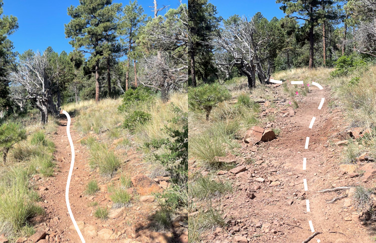
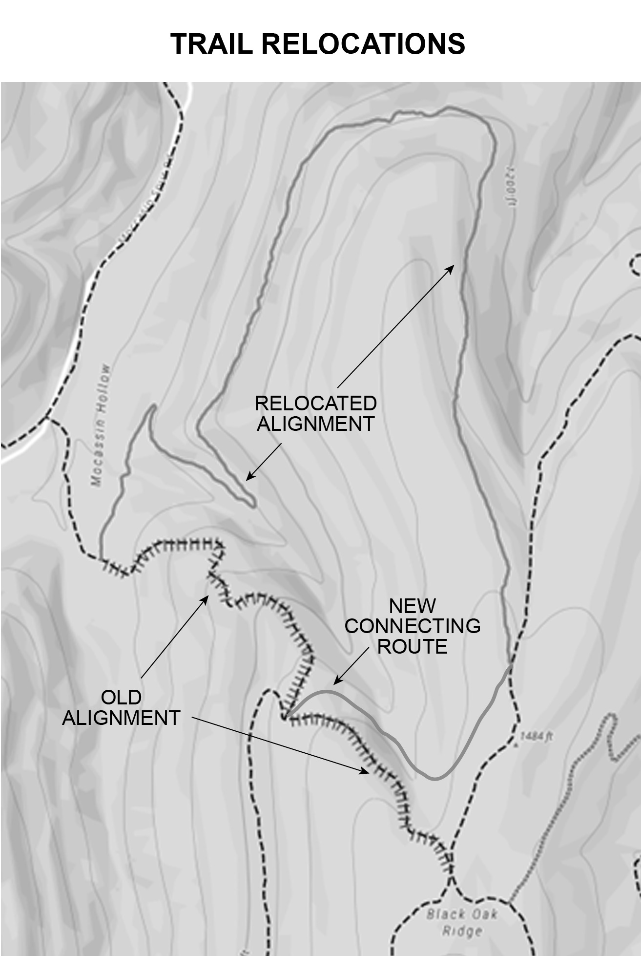
Constructing a new alignment of an existing trail outside the trailway.

A map with topographic lines showing a relocated section of trail.
(USDA Forest Service illustration)

An earthen structure with log or rock retainers that elevate the trail tread and ditches that direct water away from the tread in an area of saturated soil.

Earthen structure over a saturated area lined with logs on either side of the trail and capped with fill.
(USDA photo by Chris Bouton, San Juan National Forest, Colorado)
A labeled illustration of the cross section of a turnpike with a gravel base.
(USDA Forest Service Illustration)

Complex rock and earthen structure that allows water from small springs or seeps to flow under the tread surface. They can be constructed with and without slotted plastic pipe. The slots should only be on the top half of the pipe.

A labeled illustration of a rock structure under a trail with thin arrows indicating water flow under the trail through voids between the rocks.
(USDA Forest Service illustration)

Severe bend in a piece of lumber or timber making it unusable in its original length. The warp can be in different directions. Sometimes the warp occurs mostly at one point, usually a knot, and short usable pieces can be cut on either side of that point.

A labeled illustration showing four different types of warp - cup, bow, crook, and twist.
(USDA Forest Service illustration)

A linear feature made from embedded rock or wood set at a 45- to 60-degree angle across the trail tread to direct water off the trail. They should only be used on minimally developed (class 1) hiking or equestrian trails where obstacles are appropriate.

A forest trail with a failed water bar made from a log and large rocks set within the trail, however the water bar has failed to keep water from running down the trail.
A Trail in a forest with failed water bar. (USDA Forest Service photo by Kerry Wood, Cibola National Forest, New Mexico)

The level below the ground surface where groundwater will fill a test hole.

A labeled illustration of seasonal elevations of a water table.
(USDA Forest Service illustration)

Trail widening commonly occurs in muddy, fall line, and flat areas when traffic skirts the edge and tramples the vegetation and compacts soil beyond the edge of the trail tread.

A puddle of water in the tread with an obvious foot path around the puddle that is widening the trail.
A puddle of water in the tread with an obvious foot path around the puddle that is widening the trail. (USDA Forest Service photo by Kristen Thrall, Chequamegon-Nicolet National Forest, Wisconsin)