

Detection Surveys

The Cooperative Forestry Assistance Act of 1978, As Amended Through 2008, Section 8, [16 U.S.C. 2104] FOREST HEALTH PROTECTION, authorizes the Forest Service to "conduct surveys to detect and appraise insect infestations and disease conditions and man-made stresses affecting trees and establish a monitoring system throughout the forests of the United States to determine detrimental changes or improvements that occur over time, and report annually concerning such surveys and monitoring".
Detection surveys are the primary method of collecting data on the health of treed areas affected by insects and diseases. Aerial and ground surveys using applications like Digital Mobile Sketch Mapping (DMSM) and Southern Pine Beetle (SPB) Collector Map are conducted annually. Geospatial data collected with these systems is stored in a National Insect and Disease Survey (IDS) database. Various products are available for download below including National Insect and Disease Detection Survey Maps, IDS Geospatial Data, and IDS Acre Summaries. The annual Detection surveys data is also used to produce Forest Insect and Disease Conditions in the United States reports and National Forest Health Conditions & Highlights Interactive Story Maps.
Detection surveys are an efficient and economical method of collecting and reporting data on forest insects, diseases, and other disturbances across State, Private and Federal lands. FHAAST supports cooperating users and Forest Service Regions each field season with detection surveys. Cooperators are the key to ensuring consistent coverage and quality of the detection data.
National Insect and Disease Detection Survey Summary Maps
National Insect and Disease Detection Survey Maps
Select Map by Year
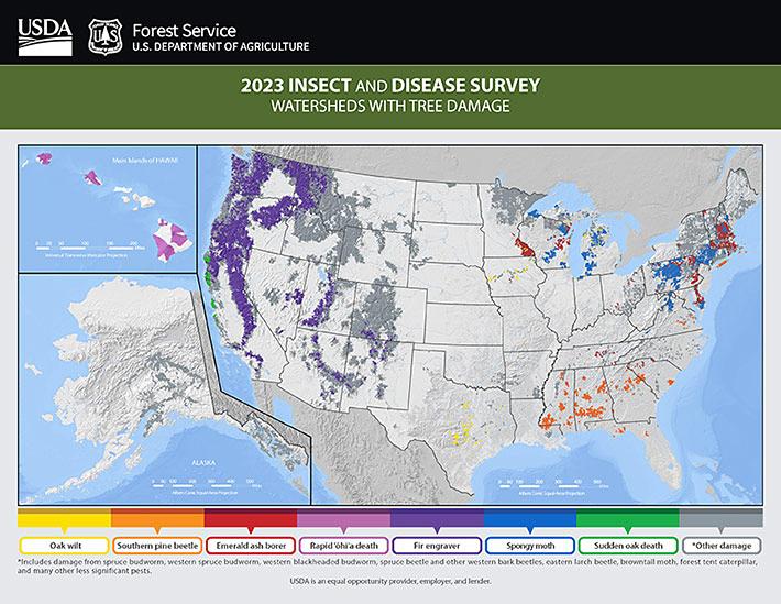
2023 Insect and Disease Detection Survey Highlights
2023 Insect and Disease Detection Survey Highlights Poster
2022 Insect and Disease Detection Survey Highlights
2022 Insect and Disease Detection Survey Highlights Poster
2021 Insect and Disease Detection Survey Highlights
2021 Insect and Disease Detection Survey Highlights Poster
2020 Insect and Disease Detection Survey Highlights
2020 Insect and Disease Detection Survey Highlights Poster
2019 Insect and Disease Detection Survey Highlights
2019 Insect and Disease Detection Survey Highlights Poster
Insect & Disease Detection Survey (IDS) Data Submission Template
This following zip file contains a file geodatabase with template feature classes, a spreadsheet describing the table schemas, required fields, domains and notes, a python code snippet to help calculate the required feature IDs and a supporting document.
IDS Data Submission Template (620KB ZIP)
Insect & Disease Detection Survey (IDS) Data Downloads
R1 IDS DATA DOWNLOADS
R2 IDS DATA DOWNLOADS
R3 IDS DATA DOWNLOADS
R4 IDS DATA DOWNLOADS
R5 IDS DATA DOWNLOADS
R6 IDS DATA DOWNLOADS
R8 IDS DATA DOWNLOADS
R9 IDS DATA DOWNLOADS
R10 IDS DATA DOWNLOADS
Read reports about forest insect and disease conditions in the United States. The reports focus on the 20 major insects and diseases that annually cause defoliation and mortality in forests of the United States.
Insect and Disease Detection Survey Acre Summaries
2000-2020 Areas with Tree Mortality from Bark Beetles in the Western United States