USDA, RMRS, Water and Watersheds logo USDA RMSR AWAE RMRS
  • ABOUT AWAE
    • About Us
    • Scientist Profiles
  • RESEARCH
    • Aquatic Ecology
    • Atmospheric Sciences
    • Biogeochemistry
    • Climate Change
    • Engineering
    • Fire & Fuels
    • Fisheries
    • Geomorphology
    • Hydrology
    • Invasive Species
    • Plant Physiology
    • Sediment & Erosion
    • Spatial Analysis
    • Watershed Processes
  • PROJECTS, TOOLS, & DATA
    • Click for Complete List of AWAE Projects, Tools, & Data
    • The Aquatic eDNAtlas Project
      • eDNAtlas Sample Results
      • Supporting Science
      • FAQ & Field Protocol
      • eDNA Sampling Grid
      • Project Background
      • Contacts
    • Bull Trout eDNA Project
      • eDNA Sampling & Supporting Science
      • Participating in the Bull Trout eDNA Survey
      • Bull Trout eDNA Sample Sites
      • The Status of the Bull Trout Survey
      • Partners
    • Cold-Water Climate Shield
      • Presentations & Publications
      • Digital Maps & ArcGIS Shapefiles
      • Data Sources & Documentation
      • Trout Distribution Monitoring
      • Related Links
        • NorWeST: Regional Database & Modeled Stream Temperature
        • SSN & STARS
        • Stream Temperature Monitoring & Modeling
        • Western U.S. Stream Flow Metric Dataset
    • Cutthroat trout-rainbow trout hybridization
    • Fire & Aquatic Ecosystems
      • Management Questions
      • Publications
        • Manuscripts & Reports
        • Fire & Aquatic Bibliography
        • Science Briefings
          • Adaptation for Wildland Aquatic Resources
          • Climate Change & Wildfires
          • Wildfire Impacts on Stream Sedimentation
      • Workshops
        • 2009
          • Agenda
          • Topics & Contacts
        • 2002
          • Author Profiles
          • Special Issue in Forest Ecology and Management
          • Downloadable Papers
      • Links
      • Photo Gallery
    • Geomorphic Road Analysis & Inventory Package (GRAIP)
      • Introduction
      • Case Studies
        • Legacy Roads
        • Watershed Studies
      • Publications
        • Manuals
        • Selected Articles
        • Science Briefings
        • Posters
      • Downloads & Software
        • GRAIP_Lite
        • Database Update (2013)
        • Data Dictionary 5.0
        • Terrain Analysis (TauDEM)
      • Supporting Information
        • Calculating Base Rate
        • List of Equipment
      • Photo Galleries
        • GRAIP
        • Legacy Roads
        • Other Roads
      • Links & Models
        • FishXing
        • WEPP
        • SEDMODL2
        • STREAM TEAM
        • Water-Road Interaction Technology Series
      • Training Opportunities
      • Jobs & Summer Employment
      • Frequently Asked Questions
      • Contacts
    • GRAIP_Lite
      • Manuals & Publications
      • GRAIP_Lite FAQs
      • Training Opportunities
      • Contacts
      • GRAIP_Lite Download
      • Case Studies
    • Managing Arid and Semi-Arid Watersheds
      • about
      • basics
      • bibliography
      • bibliography - supplemental
      • credits
      • data policy
      • U.S. LTER Watershed Sites
      • history
      • links
      • web resources
    • National Stream Internet
      • Workshops and Presentations
      • NSI Hydrography Network
      • Databases of Stream Reach Descriptors
      • Databases of Stream Measurements
      • SSN Bibliography
    • NorWeST: Regional Database & Modeled Stream Temperature
      • Project Boundary
      • Processing Status
      • Data Downloads
        • Stream Temperature Database
        • Modeled Stream Temperatures
      • Interactive Map
      • Publications
        • Supporting Research
        • Science Briefings
        • Posters & Presentations
        • Blogs & Newsletters
      • Supporting Information
        • Reconditioned NHD Plus
        • Regional Climate Downscaling
        • Climate-Aquatics Blog
        • 2011 Climate-Aquatics Decision Support Workshop
      • Related Links
        • Cold-Water Climate Shield
        • SSN & STARS
        • Stream Temperature Monitoring & Modeling
        • Western U.S. Stream Flow Metric Dataset
      • Contacts & Contributors
    • River Bathymetry Toolkit (RBT)
      • Introduction
      • Downloads
      • Sample Data
      • Publications
      • Presentations
      • Demonstration Videos
      • Reviews
      • Disclaimer & Citation
      • Acknowledgements
    • Sediment Transport
      • Idaho & Nevada
        • Publications
        • FAQ & Contact Us
      • Colorado & Wyoming
        • Publications
        • FAQ & Contact Us
    • Spatial Statistical Modeling of Streams (SSN & STARS)
      • Frequently Asked Questions
      • Software & Data
      • GIS Layers
      • Publications & Presentations
      • Latest Releases
      • Authors & Contacts
      • Other Software
      • News
    • Stream Temperature Monitoring & Modeling
      • Protocols and Resources
      • Interactive Maps
      • Modeling
        • Air Temperature Model
        • Multiple Regression Model
        • Spatial Statistical Model
        • SSN & STARS
        • NorWeST
      • Resources
        • Climate Change Resource Center
        • Climate-Aquatics Blog
        • Climate-Aquatics Workshop
        • Temperature Data Macro
      • Publications
        • Publications & Presentations
        • Science Briefings
    • Understanding the diversity of Cottus in western North America
      • Current Contributions
      • Collection Particulars
      • Species of Interest
      • Phylogeography and Maps
      • Publications and Posters
      • Briefing Papers
      • Contact
    • Valley Bottom Confinement
      • Download VCA Script & Toolbox
      • Publications
    • Water Erosion Prediction Project (WEPP)
      • Forest Management
        • Disturbed WEPP
        • Disturbed WEPP Batch
        • ERMiT
        • ERMiT Batch
        • WEPP FuME
        • Tahoe Basin Sediment Model
      • Road Erosion
        • WEPP: Road
        • WEPP: Road Batch
      • Fire Effects
        • Disturbed WEPP
        • Disturbed WEPP Batch
        • ERMiT
        • ERMiT Batch
        • WEPP FuME
      • WEPP Climate Parameter Files
        • Rock:Clime
      • Peak Flow Calculator
      • Additional WEPP Resources
    • Western U.S. Stream Flow Metric Dataset
      • Dataset Downloads
      • Publications
        • Macroscale Hydrologic Modeling
        • Comparison of VIC/MC1 Models to Observed Gage Data
        • Science Briefing
      • Contacts
        • Charlie Luce
        • Seth Wenger
      • Links
        • NHD Plus
        • University of Washington Climate Impacts Group
        • Trout Unlimited Science Page
        • Climate-Aquatics Blog
      • Related Websites
        • SSN & STARS
        • Reconditioned NHD Plus
        • NorWeST Stream Temperature
        • Stream Temperature Modeling & Monitoring
  • PUBLICATIONS
    • Search Publications (TreeSearch)
    • Recent AWAE Publications
    • All Available AWAE Publications
    • Publications by Project or Research Subject
      • Biogeochemistry
      • Environmental DNA
      • Climate Change
      • Engineering
      • Fire & Aquatic Ecosystems
      • Geomorphic Road Analysis & Inventory Package (GRAIP)
      • Glacier Lakes Ecosystem Experiments Site (GLEES)
      • Invasive Aquatic Species
      • NorWeST Stream Temperature Regional Database & Model
      • River Bathymetry Toolkit (RBT)
      • Sediment Transport
        • Idaho/Nevada
        • Colorado/Wyoming
      • Spatial Statistical Modeling of Stream Networks (SSN & STARS)
      • Stream Temperature Modeling & Monitoring
      • Threats Assessment for Western Riparian Ecosystems
    • Science Briefings
      • Search by Title
      • Search by Researcher
      • Search by Subject
    • General Technical Reports
      • Search by Title
      • Search by Researcher
      • Search by Subject
  • CONTACT US
    • Locations
      • Albuquerque Forestry Sciences Lab
      • Boise Aquatic Sciences Lab
      • Flagstaff Forestry Sciences Lab
      • Fort Collins Biogeochemistry Lab
      • Fort Collins Forestry Sciences Lab
      • Missoula Fire Sciences Lab
      • Moscow Forestry Sciences Lab
    • Employee Profiles
    • Jobs & Employment
    • Website Feedback
    search only GRAIP   
Home    Projects    GRAIP    OTHER ROADS PHOTOS

***Please credit the "USDA Forest Service" when using these images.

 
broken berm Broken berm resulting in non-engineered drain with fill erosion.  
  Boise NF.  
 
fillslope erosion
 

Fillslope erosion and sediment transport

Boise NF.


gully rip rap failed
 

Expanding gully with ineffective rip-rap.


gully diffuser
 

Gully below ditch relief culvert with flow diffuser


gully pipe
 

Gully below ditch relief culvert with flow diffuser


gully - South Fork Boise River
 

Gully below ditch relief culvert with flow diffuser

Boise NF.
 
 
gully
 

Gully below ditch relief culvert with flow diffuser (same area as previous Boise NF photo)

with Tom Black and stadia for scale
 
 
gully - Wilderness Ranch
 

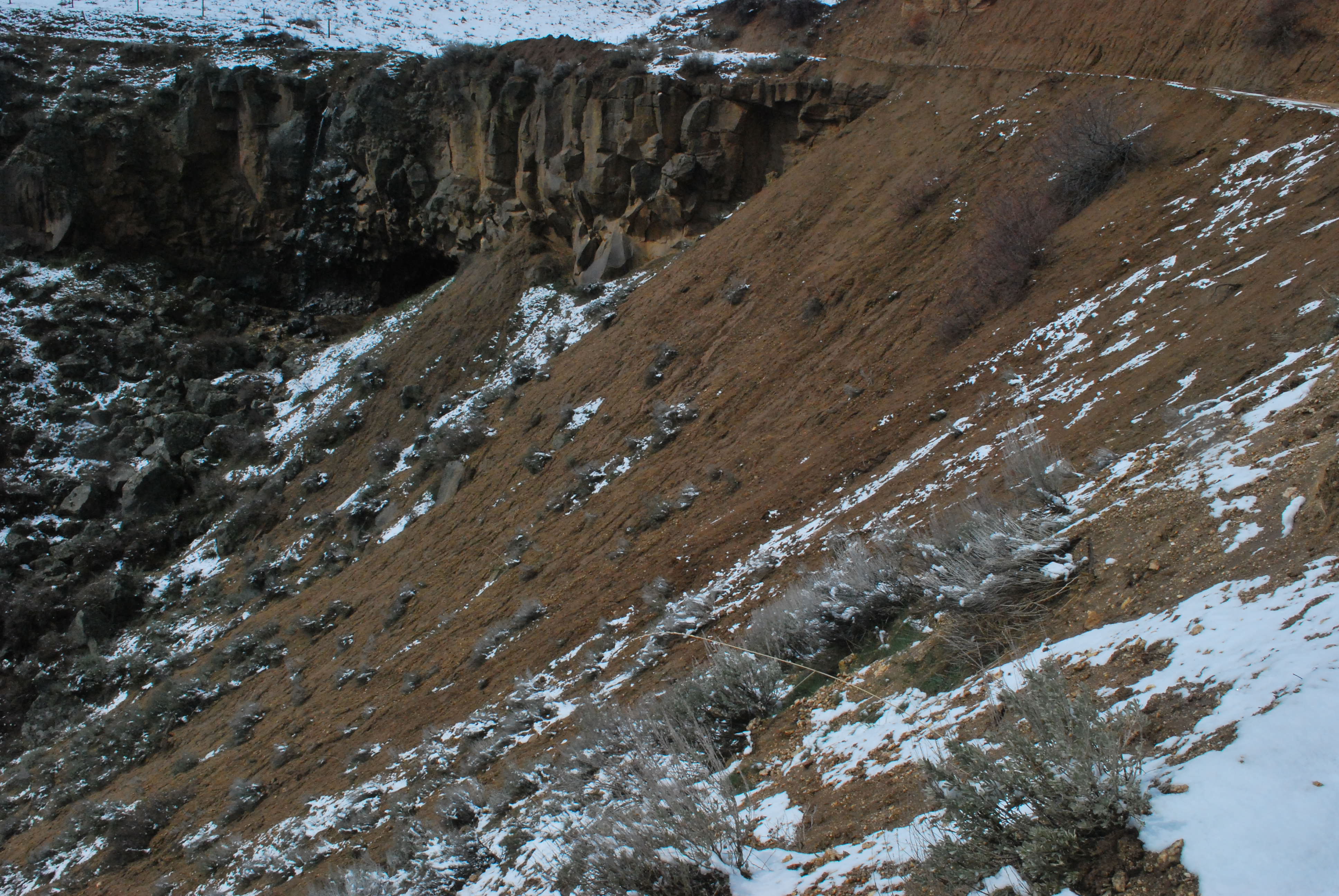
Gully, Wilderness Ranch, Idaho.

photo credit: Steve Sweet


jammer roads
 

Jammer roads in burn area.


long fillsope gully
 

Long gullies in and below fill slope.

Boise NF.


wheel in the mud
 

Rut formation in muddy road.


non eng
 

Non-engineered drain.

Boise, NF.


sed del ditch
 

Sediment transport to ditch relief culvert

Boise NF.


stream crossing
 

Surveying a stream crossing.

Boise NF.


tightline gully
 

Gully below ditch relief culvert.

Boise NF.


gully
 

Surveying gully depth

Boise NF.


two (2) gullies
 

Flow diffuser with two gullies.


Find AWAE and follow us on your favorite social media site:

facebook
twitter
youtube
email


  |  RMRS Home  |   AWAE Home  |   Disclaimers  |   Freedom of Information Act (FOIA)  |   Privacy Notice  |   Quality of Information  |   Print This Page  |