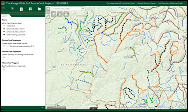
USDA, RMRS, AWAE logo USDA RMRS AWAE RMRS
  • ABOUT W&W
    • About Us
    • Scientist Profiles
  • RESEARCH
    • Aquatic Ecology
    • Atmospheric Sciences
    • Biogeochemistry
    • Climate Change
    • Engineering
    • Fire & Fuels
    • Fisheries
    • Geomorphology
    • Hydrology
    • Invasive Species
    • Plant Physiology
    • Sediment & Erosion
    • Spatial Analysis
    • Watershed Processes
  • PROJECTS, TOOLS, & DATA
    • Click for Complete List of W&W Projects, Tools, & Data
    • The Aquatic eDNAtlas Project
      • eDNAtlas Sample Results
      • Supporting Science
      • FAQ & Field Protocol
      • eDNA Sampling Grid
      • Project Background
      • Contacts
    • Bull Trout eDNA Project
      • eDNA Sampling & Supporting Science
      • Participating in the Bull Trout eDNA Survey
      • Bull Trout eDNA Sample Sites
      • The Status of the Bull Trout Survey
      • Partners
    • Cold-Water Climate Shield
      • Presentations & Publications
      • Digital Maps & ArcGIS Shapefiles
      • Data Sources & Documentation
      • Trout Distribution Monitoring
      • Related Links
        • NorWeST: Regional Database & Modeled Stream Temperature
        • SSN & STARS
        • Stream Temperature Monitoring & Modeling
        • U.S. Stream Flow Metric Dataset
    • Cutthroat trout-rainbow trout hybridization
    • Fire & Aquatic Ecosystems
      • Management Questions
      • Publications
        • Manuscripts & Reports
        • Fire & Aquatic Bibliography
        • Science Briefings
          • Adaptation for Wildland Aquatic Resources
          • Climate Change & Wildfires
          • Wildfire Impacts on Stream Sedimentation
      • Workshops
        • 2009
          • Agenda
          • Topics & Contacts
        • 2002
          • Author Profiles
          • Special Issue in Forest Ecology and Management
          • Downloadable Papers
      • Links
      • Photo Gallery
    • Geomorphic Road Analysis & Inventory Package (GRAIP)
      • Introduction
      • Case Studies
        • Legacy Roads
        • Watershed Studies
      • Publications
        • Manuals
        • Selected Articles
        • Science Briefings
        • Posters
      • Downloads & Software
        • Database Update (2013)
        • Data Dictionary 5.0
        • Terrain Analysis (TauDEM)
      • Supporting Information
        • Calculating Base Rate
        • List of Equipment
      • Photo Galleries
        • GRAIP
        • Legacy Roads
        • Other Roads
      • Links & Models
        • FishXing
        • WEPP
        • SEDMODL2
        • STREAM TEAM
        • Water-Road Interaction Technology Series
      • Training Opportunities
      • Jobs & Summer Employment
      • Frequently Asked Questions
      • Contacts
    • National Stream Internet
      • Workshops and Presentations
      • NSI Hydrography Network
      • Databases of Stream Reach Descriptors
      • Databases of Stream Measurements
      • SSN Bibliography
    • NorWeST: Regional Database & Modeled Stream Temperature
      • Project Boundary
      • Processing Status
      • Data Downloads
        • Stream Temperature Database
        • Modeled Stream Temperatures
      • Interactive Map
      • Publications
        • Supporting Research
        • Science Briefings
        • Posters & Presentations
        • Blogs & Newsletters
      • Supporting Information
        • Reconditioned NHD Plus
        • Regional Climate Downscaling
        • Climate-Aquatics Blog
        • 2011 Climate-Aquatics Decision Support Workshop
      • Related Links
        • Cold-Water Climate Shield
        • SSN & STARS
        • Stream Temperature Monitoring & Modeling
        • U.S. Stream Flow Metric Dataset
      • Contacts & Contributors
    • Sediment Transport
      • Idaho & Nevada
        • Publications
        • FAQ & Contact Us
      • Colorado & Wyoming
        • Publications
        • FAQ & Contact Us
    • Spatial Statistical Modeling of Streams (SSN & STARS)
      • Frequently Asked Questions
      • Software & Data
      • GIS Layers
      • Publications & Presentations
      • Latest Releases
      • Authors & Contacts
      • Other Software
      • News
    • Stream Temperature Monitoring & Modeling
      • Protocols and Resources
      • Interactive Maps
      • Modeling
        • Air Temperature Model
        • Multiple Regression Model
        • Spatial Statistical Model
        • SSN & STARS
        • NorWeST
      • Resources
        • Climate Change Resource Center
        • Climate-Aquatics Blog
        • Climate-Aquatics Workshop
        • Temperature Data Macro
      • Publications
        • Publications & Presentations
        • Science Briefings
    • Understanding the diversity of Cottus in western North America
      • Current Contributions
      • Phylogeny and Maps
      • Publications and Posters
      • Contact
    • Valley Bottom Confinement
      • Download Valley Bottom Shapefiles
      • Download VCA Script & Toolbox
      • Publications
    • Water Erosion Prediction Project (WEPP)
      • Forest Management
        • Disturbed WEPP
        • Disturbed WEPP Batch
        • ERMiT
        • ERMiT Batch
        • WEPP FuME
        • Tahoe Basin Sediment Model
      • Road Erosion
        • WEPP: Road
        • WEPP: Road Batch
      • Fire Effects
        • Disturbed WEPP
        • Disturbed WEPP Batch
        • ERMiT
        • ERMiT Batch
        • WEPP FuME
      • WEPP Climate Parameter Files
        • Rock:Clime
      • Peak Flow Calculator
      • Additional WEPP Resources
    • U.S. Stream Flow Metric Dataset
      • Dataset Downloads
      • Publications
        • Macroscale Hydrologic Modeling
        • Comparison of VIC/MC1 Models to Observed Gage Data
        • Science Briefing
      • Contacts
        • Charlie Luce
        • Seth Wenger
      • Links
        • NHD Plus
        • University of Washington Climate Impacts Group
        • Trout Unlimited Science Page
        • Climate-Aquatics Blog
      • Related Websites
        • SSN & STARS
        • Reconditioned NHD Plus
        • NorWeST Stream Temperature
        • Stream Temperature Modeling & Monitoring
  • PUBLICATIONS
    • Search Publications (TreeSearch)
    • Recent W&W Publications
    • All Available W&W Publications
    • Publications by Project or Research Subject
      • Biogeochemistry
      • Environmental DNA
      • Climate Change
      • Engineering
      • Fire & Aquatic Ecosystems
      • Geomorphic Road Analysis & Inventory Package (GRAIP)
      • Glacier Lakes Ecosystem Experiments Site (GLEES)
      • Invasive Aquatic Species
      • NorWeST Stream Temperature Regional Database & Model
      • River Bathymetry Toolkit (RBT)
      • Sediment Transport
        • Idaho/Nevada
        • Colorado/Wyoming
      • Spatial Statistical Modeling of Stream Networks (SSN & STARS)
      • Stream Temperature Modeling & Monitoring
      • Threats Assessment for Western Riparian Ecosystems
    • Science Briefings
      • Search by Title
      • Search by Researcher
      • Search by Subject
    • General Technical Reports
      • Search by Title
      • Search by Researcher
      • Search by Subject
  • CONTACT US
    • Locations
      • Albuquerque Forestry Sciences Lab
      • Boise Aquatic Sciences Lab
      • Flagstaff Forestry Sciences Lab
      • Fort Collins Biogeochemistry Lab
      • Fort Collins Forestry Sciences Lab
      • Missoula Fire Sciences Lab
      • Moscow Forestry Sciences Lab
    • Employee Profiles
    • Jobs & Employment
    • Website Feedback
    search only W&W
Home Projects The Range-Wide Bull Trout eDNA Project  The Status of the Bull Trout Survey

The Status of the Bull Trout Survey

Bull Trout Survey Status Maps

The completed bull trout eDNA survey results Online Map allows users to view the survey results in an interactive map. The map provides the ability to zoom in and look at an area of interest, as well as to create queries or select an area to download points as a shapefile. Please note that there are some issues with IE and it's recommended to use a different browser.

AGOL User Guide |    Metadata  |  Download bull trout eDNA shapefile

If you have questions about the map, please contact Sharon (Parkes) Payne. If you have questions about the eDNA sampling, please contact Tommy Franklin.

PDF maps by HUC 8 can be found on the Sample Sites page.

Cite as: Young, Michael K.; Isaak, Daniel J.; McKelvey, Kevin S.; Schwartz, Michael K.; Carim, Kellie J.; Fredenberg, W.; Wilcox, Taylor M.; Franklin, T.; Chandler, Gwynne L.; Nagel, David E.; Parkes-Payne, Sharon L.; Horan, Dona L.; Wollrab, Sherry P. 2017. Species occurrence data from the Range-Wide Bull Trout eDNA Project. Fort Collins, CO: Forest Service Research Data Archive. Updated 05 June 2021. https://doi.org/10.2737/RDS-2017-0038


Resources

eDNA Sampling & Supporting Science
collecting eDNA in  streams
eDNA Sampling Maps & Coordinates
Bull Trout Survey Status Interactive and Static Maps

eDNA Sampling &
Supporting Science

Participating in the
Bull Trout eDNA Survey

Bull Trout eDNA
Sample Sites

Completed Bull Trout eDNA Survey Results


Related Websites

The Aquatic eDNAtlas Project

The National Stream Internet

NorWeST: Regional Database & Modeled Stream Temperature

SSN & STARS: Tools for Spatial Statistical Modeling on Stream Networks

Stream Temperature Modeling and Monitoring

Climate-Aquatics Blog

U.S. Stream Flow Metric Dataset

National Genomics Center for Wildlife and Fish Conservation

Sculpins of the West - A molecular taxonomy of Cottus in western North America


Home Projects  The Range-Wide Bull Trout eDNA Project  The Status of the Bull Trout Survey ;

Find W&W and follow us on your favorite social media site:

facebook
twitter
youtube
email


| RMRS Home | W&W Home | Disclaimers | Freedom of Information Act (FOIA) | Privacy Notice | Quality of Information | Print This Page |