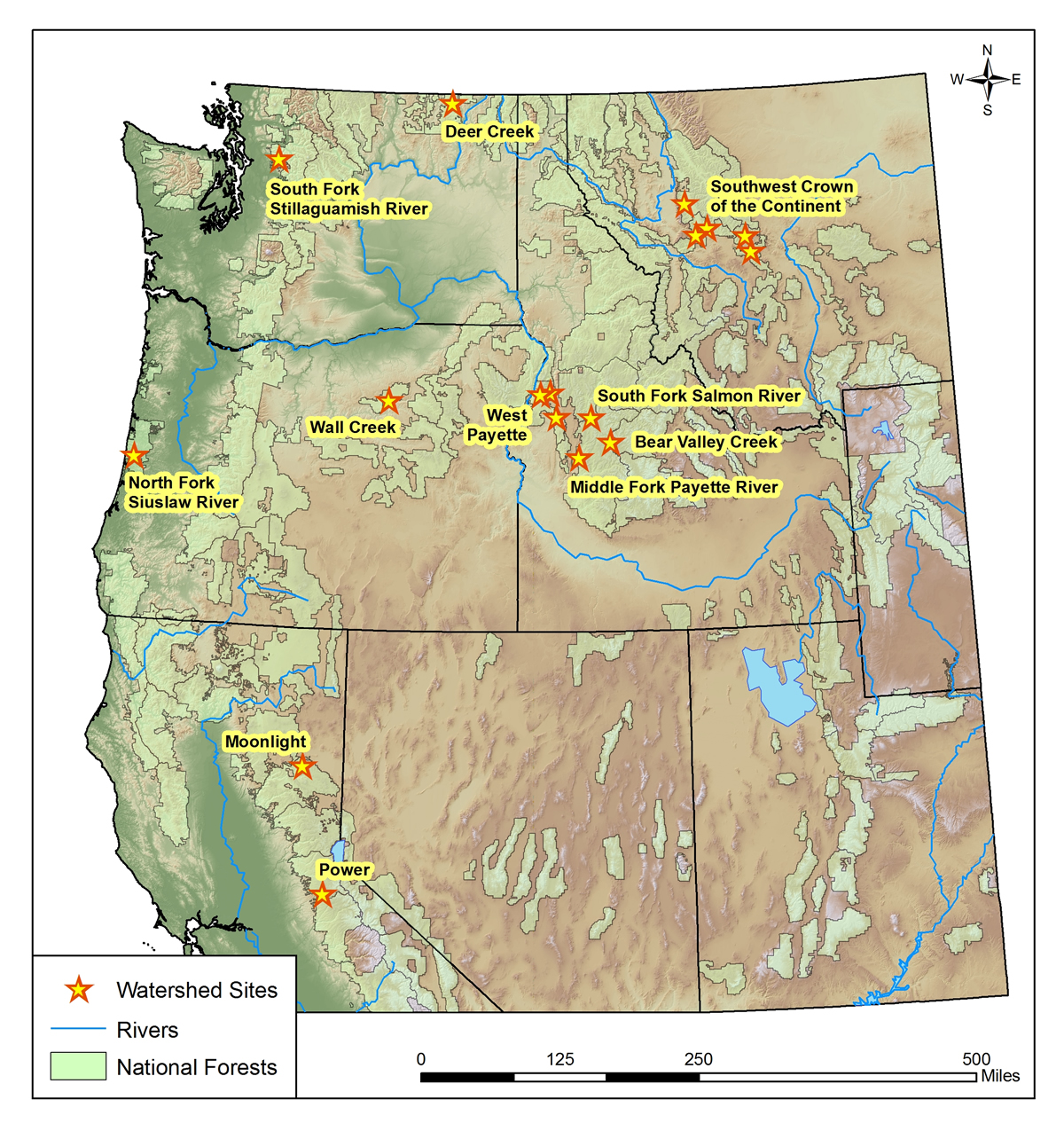
USDA, RMRS, Water and Watersheds logo USDA RMSR AWAE RMRS
  • ABOUT AWAE
    • About Us
    • Scientist Profiles
  • RESEARCH
    • Aquatic Ecology
    • Atmospheric Sciences
    • Biogeochemistry
    • Climate Change
    • Engineering
    • Fire & Fuels
    • Fisheries
    • Geomorphology
    • Hydrology
    • Invasive Species
    • Plant Physiology
    • Sediment & Erosion
    • Spatial Analysis
    • Watershed Processes
  • PROJECTS, TOOLS, & DATA
    • Click for Complete List of AWAE Projects, Tools, & Data
    • The Aquatic eDNAtlas Project
      • eDNAtlas Sample Results
      • Supporting Science
      • FAQ & Field Protocol
      • eDNA Sampling Grid
      • Project Background
      • Contacts
    • Bull Trout eDNA Project
      • eDNA Sampling & Supporting Science
      • Participating in the Bull Trout eDNA Survey
      • Bull Trout eDNA Sample Sites
      • The Status of the Bull Trout Survey
      • Partners
    • Cold-Water Climate Shield
      • Presentations & Publications
      • Digital Maps & ArcGIS Shapefiles
      • Data Sources & Documentation
      • Trout Distribution Monitoring
      • Related Links
        • NorWeST: Regional Database & Modeled Stream Temperature
        • SSN & STARS
        • Stream Temperature Monitoring & Modeling
        • Western U.S. Stream Flow Metric Dataset
    • Cutthroat trout-rainbow trout hybridization
    • Fire & Aquatic Ecosystems
      • Management Questions
      • Publications
        • Manuscripts & Reports
        • Fire & Aquatic Bibliography
        • Science Briefings
          • Adaptation for Wildland Aquatic Resources
          • Climate Change & Wildfires
          • Wildfire Impacts on Stream Sedimentation
      • Workshops
        • 2009
          • Agenda
          • Topics & Contacts
        • 2002
          • Author Profiles
          • Special Issue in Forest Ecology and Management
          • Downloadable Papers
      • Links
      • Photo Gallery
    • Geomorphic Road Analysis & Inventory Package (GRAIP)
      • Introduction
      • Case Studies
        • Legacy Roads
        • Watershed Studies
      • Publications
        • Manuals
        • Selected Articles
        • Science Briefings
        • Posters
      • Downloads & Software
        • GRAIP_Lite
        • Database Update (2013)
        • Data Dictionary 5.0
        • Terrain Analysis (TauDEM)
      • Supporting Information
        • Calculating Base Rate
        • List of Equipment
      • Photo Galleries
        • GRAIP
        • Legacy Roads
        • Other Roads
      • Links & Models
        • FishXing
        • WEPP
        • SEDMODL2
        • STREAM TEAM
        • Water-Road Interaction Technology Series
      • Training Opportunities
      • Jobs & Summer Employment
      • Frequently Asked Questions
      • Contacts
    • GRAIP_Lite
      • Manuals & Publications
      • GRAIP_Lite FAQs
      • Training Opportunities
      • Contacts
      • GRAIP_Lite Download
      • Case Studies
    • Managing Arid and Semi-Arid Watersheds
      • about
      • basics
      • bibliography
      • bibliography - supplemental
      • credits
      • data policy
      • U.S. LTER Watershed Sites
      • history
      • links
      • web resources
    • National Stream Internet
      • Workshops and Presentations
      • NSI Hydrography Network
      • Databases of Stream Reach Descriptors
      • Databases of Stream Measurements
      • SSN Bibliography
    • NorWeST: Regional Database & Modeled Stream Temperature
      • Project Boundary
      • Processing Status
      • Data Downloads
        • Stream Temperature Database
        • Modeled Stream Temperatures
      • Interactive Map
      • Publications
        • Supporting Research
        • Science Briefings
        • Posters & Presentations
        • Blogs & Newsletters
      • Supporting Information
        • Reconditioned NHD Plus
        • Regional Climate Downscaling
        • Climate-Aquatics Blog
        • 2011 Climate-Aquatics Decision Support Workshop
      • Related Links
        • Cold-Water Climate Shield
        • SSN & STARS
        • Stream Temperature Monitoring & Modeling
        • Western U.S. Stream Flow Metric Dataset
      • Contacts & Contributors
    • River Bathymetry Toolkit (RBT)
      • Introduction
      • Downloads
      • Sample Data
      • Publications
      • Presentations
      • Demonstration Videos
      • Reviews
      • Disclaimer & Citation
      • Acknowledgements
    • Sediment Transport
      • Idaho & Nevada
        • Publications
        • FAQ & Contact Us
      • Colorado & Wyoming
        • Publications
        • FAQ & Contact Us
    • Spatial Statistical Modeling of Streams (SSN & STARS)
      • Frequently Asked Questions
      • Software & Data
      • GIS Layers
      • Publications & Presentations
      • Latest Releases
      • Authors & Contacts
      • Other Software
      • News
    • Stream Temperature Monitoring & Modeling
      • Protocols and Resources
      • Interactive Maps
      • Modeling
        • Air Temperature Model
        • Multiple Regression Model
        • Spatial Statistical Model
        • SSN & STARS
        • NorWeST
      • Resources
        • Climate Change Resource Center
        • Climate-Aquatics Blog
        • Climate-Aquatics Workshop
        • Temperature Data Macro
      • Publications
        • Publications & Presentations
        • Science Briefings
    • Understanding the diversity of Cottus in western North America
      • Current Contributions
      • Collection Particulars
      • Species of Interest
      • Phylogeography and Maps
      • Publications and Posters
      • Briefing Papers
      • Contact
    • Valley Bottom Confinement
      • Download VCA Script & Toolbox
      • Publications
    • Water Erosion Prediction Project (WEPP)
      • Forest Management
        • Disturbed WEPP
        • Disturbed WEPP Batch
        • ERMiT
        • ERMiT Batch
        • WEPP FuME
        • Tahoe Basin Sediment Model
      • Road Erosion
        • WEPP: Road
        • WEPP: Road Batch
      • Fire Effects
        • Disturbed WEPP
        • Disturbed WEPP Batch
        • ERMiT
        • ERMiT Batch
        • WEPP FuME
      • WEPP Climate Parameter Files
        • Rock:Clime
      • Peak Flow Calculator
      • Additional WEPP Resources
    • Western U.S. Stream Flow Metric Dataset
      • Dataset Downloads
      • Publications
        • Macroscale Hydrologic Modeling
        • Comparison of VIC/MC1 Models to Observed Gage Data
        • Science Briefing
      • Contacts
        • Charlie Luce
        • Seth Wenger
      • Links
        • NHD Plus
        • University of Washington Climate Impacts Group
        • Trout Unlimited Science Page
        • Climate-Aquatics Blog
      • Related Websites
        • SSN & STARS
        • Reconditioned NHD Plus
        • NorWeST Stream Temperature
        • Stream Temperature Modeling & Monitoring
  • PUBLICATIONS
    • Search Publications (TreeSearch)
    • Recent AWAE Publications
    • All Available AWAE Publications
    • Publications by Project or Research Subject
      • Biogeochemistry
      • Environmental DNA
      • Climate Change
      • Engineering
      • Fire & Aquatic Ecosystems
      • Geomorphic Road Analysis & Inventory Package (GRAIP)
      • Glacier Lakes Ecosystem Experiments Site (GLEES)
      • Invasive Aquatic Species
      • NorWeST Stream Temperature Regional Database & Model
      • River Bathymetry Toolkit (RBT)
      • Sediment Transport
        • Idaho/Nevada
        • Colorado/Wyoming
      • Spatial Statistical Modeling of Stream Networks (SSN & STARS)
      • Stream Temperature Modeling & Monitoring
      • Threats Assessment for Western Riparian Ecosystems
    • Science Briefings
      • Search by Title
      • Search by Researcher
      • Search by Subject
    • General Technical Reports
      • Search by Title
      • Search by Researcher
      • Search by Subject
  • CONTACT US
    • Locations
      • Albuquerque Forestry Sciences Lab
      • Boise Aquatic Sciences Lab
      • Flagstaff Forestry Sciences Lab
      • Fort Collins Biogeochemistry Lab
      • Fort Collins Forestry Sciences Lab
      • Missoula Fire Sciences Lab
      • Moscow Forestry Sciences Lab
    • Employee Profiles
    • Jobs & Employment
    • Website Feedback
    search only GRAIP   
Home    Projects    GRAIP    INTRODUCTION
GRAIP collage

Geomorphic Road Assessment and Inventory Package (GRAIP)

GRAIP is a process and a set of tools for analyzing the impacts of roads on forested watersheds. GRAIP combines a road inventory with a powerful GIS analysis tool set to predict sediment production and delivery, mass wasting risk from gullies and landslides, stream diversion potential, culvert maintenance, and fish passage at stream crossings.

The road inventory protocol describes how to systematically field inventory a road system using GPS and automated data forms. Once downloaded, these data can be immediately run through a data quality checking and correction program. Quality checked data can then be analyzed in a program implemented in ArcGIS. The program produces maps of surface erosion, accumulated road sediment in streams, and contributing length by segment, which relates directly to slope stability and gullying risks. Other analyses relating to stream diversion potential, stream crossing failure, culvert maintenance needs, and fish passage are also provided with the program.

Why use GRAIP? | What is GRAIP? | How does GRAIP work? | Who Supports and Uses GRAIP? | Where can I learn more about GRAIP? | When is Training Available?


Why use GRAIP?

Roads have been shown to alter the hydrologic and geomorphic response of watersheds and can impact aquatic ecosystems and degrade water quality. GRAIP can be applied at a variety of spatial scales, but is well suited to capture the multiple effects of roads at a sub-watershed scale to identify the most critical restoration opportunities.

What is GRAIP?

GRAIP is the Geomorphic Roads Analysis and Inventory Package. It is a simple and free road inventory and modeling tool designed to quantify road impacts on streams and to help land managers efficiently evaluate the multiple aspects of risk created by forest roads.

How does GRAIP work?

GRAIP uses a detailed GPS based road inventory to inform fine sediment erosion, shallow landslide and gully modeling tools that run in ArcGIS. The inventory provides information on stream crossing failure and stream diversion risks, information on the amount of road connected to the stream and a census of the road infrastructure and condition. Field crews collect about 2 miles of GRAIP inventory data a day depending on the landscape and access conditions.

Who Supports and Uses GRAIP?

GRAIP is a collaborative Joint venture between the U.S. Forest Service Rocky Mountain Research Station and Utah State University. RMRS staff supports GRAIP from the Boise Aquatic Sciences Lab. GRAIP has an active user community that includes partners inside and outside of public land management and regulatory agencies, including: the Environmental Protection Agency, the Bureau of Land Management, the Nez Perce Tribe, the Nature Conservancy, Idaho Department of Environmental Quality, the Southwest Crown of the Continent Collaborative, Coos Watershed Association, Idaho Forest Restoration Partnership, the U.S. Geological Survey, the Wilderness Society, and the Great Northern Landscape Conservation Cooperative.

Where can I learn more about GRAIP?

Detailed GRAIP data, manuals, and reports are available for selected watersheds in the Western U.S.

When is Training Available?

RMRS staff provide training each year and as needed. Check the training page for information of upcoming trainings that conduct field practice in the Boise area. Contact Tom Black with any questions.

Find AWAE and follow us on your favorite social media site:

facebook
twitter
youtube
email


  |  RMRS Home  |   AWAE Home  |   Disclaimers  |   Freedom of Information Act (FOIA)  |   Privacy Notice  |   Quality of Information  |   Print This Page  |