USDA, RMRS, AWAE logo USDA RMRS AWAE RMRS
  • ABOUT W&W
    • About Us
    • Scientist Profiles
  • RESEARCH
    • Aquatic Ecology
    • Atmospheric Sciences
    • Biogeochemistry
    • Climate Change
    • Engineering
    • Fire & Fuels
    • Fisheries
    • Geomorphology
    • Hydrology
    • Invasive Species
    • Plant Physiology
    • Sediment & Erosion
    • Spatial Analysis
    • Watershed Processes
  • PROJECTS, TOOLS, & DATA
    • Click for Complete List of W&W Projects, Tools, & Data
    • The Aquatic eDNAtlas Project
      • eDNAtlas Sample Results
      • Supporting Science
      • FAQ & Field Protocol
      • eDNA Sampling Grid
      • Project Background
      • Contacts
    • Bull Trout eDNA Project
      • eDNA Sampling & Supporting Science
      • Participating in the Bull Trout eDNA Survey
      • Bull Trout eDNA Sample Sites
      • The Status of the Bull Trout Survey
      • Partners
    • Cold-Water Climate Shield
      • Presentations & Publications
      • Digital Maps & ArcGIS Shapefiles
      • Data Sources & Documentation
      • Trout Distribution Monitoring
      • Related Links
        • NorWeST: Regional Database & Modeled Stream Temperature
        • SSN & STARS
        • Stream Temperature Monitoring & Modeling
        • U.S. Stream Flow Metric Dataset
    • Cutthroat trout-rainbow trout hybridization
    • Fire & Aquatic Ecosystems
      • Management Questions
      • Publications
        • Manuscripts & Reports
        • Fire & Aquatic Bibliography
        • Science Briefings
          • Adaptation for Wildland Aquatic Resources
          • Climate Change & Wildfires
          • Wildfire Impacts on Stream Sedimentation
      • Workshops
        • 2009
          • Agenda
          • Topics & Contacts
        • 2002
          • Author Profiles
          • Special Issue in Forest Ecology and Management
          • Downloadable Papers
      • Links
      • Photo Gallery
    • Geomorphic Road Analysis & Inventory Package (GRAIP)
      • Introduction
      • Case Studies
        • Legacy Roads
        • Watershed Studies
      • Publications
        • Manuals
        • Selected Articles
        • Science Briefings
        • Posters
      • Downloads & Software
        • Database Update (2013)
        • Data Dictionary 5.0
        • Terrain Analysis (TauDEM)
      • Supporting Information
        • Calculating Base Rate
        • List of Equipment
      • Photo Galleries
        • GRAIP
        • Legacy Roads
        • Other Roads
      • Links & Models
        • FishXing
        • WEPP
        • SEDMODL2
        • STREAM TEAM
        • Water-Road Interaction Technology Series
      • Training Opportunities
      • Jobs & Summer Employment
      • Frequently Asked Questions
      • Contacts
    • GRAIP_Lite
      • Manuals & Publications
      • GRAIP_Lite FAQs
      • Training Opportunities
      • Contacts
      • GRAIP_Lite Download
      • Case Studies
    • Managing Arid and Semi-Arid Watersheds
      • about
      • basics
      • bibliography
      • bibliography - supplemental
      • credits
      • data policy
      • U.S. LTER Watershed Sites
      • history
      • links
      • web resources
    • National Stream Internet
      • Workshops and Presentations
      • NSI Hydrography Network
      • Databases of Stream Reach Descriptors
      • Databases of Stream Measurements
      • SSN Bibliography
    • NorWeST: Regional Database & Modeled Stream Temperature
      • Project Boundary
      • Processing Status
      • Data Downloads
        • Stream Temperature Database
        • Modeled Stream Temperatures
      • Interactive Map
      • Publications
        • Supporting Research
        • Science Briefings
        • Posters & Presentations
        • Blogs & Newsletters
      • Supporting Information
        • Reconditioned NHD Plus
        • Regional Climate Downscaling
        • Climate-Aquatics Blog
        • 2011 Climate-Aquatics Decision Support Workshop
      • Related Links
        • Cold-Water Climate Shield
        • SSN & STARS
        • Stream Temperature Monitoring & Modeling
        • U.S. Stream Flow Metric Dataset
      • Contacts & Contributors
    • Sediment Transport
      • Idaho & Nevada
        • Publications
        • FAQ & Contact Us
      • Colorado & Wyoming
        • Publications
        • FAQ & Contact Us
    • Spatial Statistical Modeling of Streams (SSN & STARS)
      • Frequently Asked Questions
      • Software & Data
      • GIS Layers
      • Publications & Presentations
      • Latest Releases
      • Authors & Contacts
      • Other Software
      • News
    • Stream Temperature Monitoring & Modeling
      • Protocols and Resources
      • Interactive Maps
      • Modeling
        • NorWeST
        • SSN & STARS
        • Spatial Statistical Model
        • Multiple Regression Model
        • Air Temperature Model
      • Supporting Research & Presentations
        • Publications & Presentations
        • Science Briefings
        • Climate Aquatics Blog
    • Understanding the diversity of Cottus in western North America
      • Current Contributions
      • Phylogeny and Maps
      • Publications and Posters
      • Contact
    • Valley Bottom Confinement
      • Download Valley Bottom Shapefiles
      • Download VCA Script & Toolbox
      • Publications
    • Water Erosion Prediction Project (WEPP)
      • Forest Management
        • Disturbed WEPP
        • Disturbed WEPP Batch
        • ERMiT
        • ERMiT Batch
        • WEPP FuME
        • Tahoe Basin Sediment Model
      • Road Erosion
        • WEPP: Road
        • WEPP: Road Batch
      • Fire Effects
        • Disturbed WEPP
        • Disturbed WEPP Batch
        • ERMiT
        • ERMiT Batch
        • WEPP FuME
      • WEPP Climate Parameter Files
        • Rock:Clime
      • Peak Flow Calculator
      • Additional WEPP Resources
    • U.S. Stream Flow Metric Dataset
      • Dataset Downloads
      • Publications
        • Macroscale Hydrologic Modeling
        • Comparison of VIC/MC1 Models to Observed Gage Data
        • Science Briefing
      • Contacts
        • Charlie Luce
        • Seth Wenger
      • Links
        • NHD Plus
        • University of Washington Climate Impacts Group
        • Trout Unlimited Science Page
        • Climate-Aquatics Blog
      • Related Websites
        • SSN & STARS
        • Reconditioned NHD Plus
        • NorWeST Stream Temperature
        • Stream Temperature Modeling & Monitoring
  • PUBLICATIONS
    • Search Publications (TreeSearch)
    • Recent W&W Publications
    • All Available W&W Publications
    • Publications by Project or Research Subject
      • Biogeochemistry
      • Environmental DNA
      • Climate Change
      • Engineering
      • Fire & Aquatic Ecosystems
      • Geomorphic Road Analysis & Inventory Package (GRAIP)
      • Glacier Lakes Ecosystem Experiments Site (GLEES)
      • Invasive Aquatic Species
      • NorWeST Stream Temperature Regional Database & Model
      • River Bathymetry Toolkit (RBT)
      • Sediment Transport
        • Idaho/Nevada
        • Colorado/Wyoming
      • Spatial Statistical Modeling of Stream Networks (SSN & STARS)
      • Stream Temperature Modeling & Monitoring
      • Threats Assessment for Western Riparian Ecosystems
    • Science Briefings
      • Search by Title
      • Search by Researcher
      • Search by Subject
    • General Technical Reports
      • Search by Title
      • Search by Researcher
      • Search by Subject
  • CONTACT US
    • Locations
      • Albuquerque Forestry Sciences Lab
      • Boise Aquatic Sciences Lab
      • Flagstaff Forestry Sciences Lab
      • Fort Collins Biogeochemistry Lab
      • Fort Collins Forestry Sciences Lab
      • Missoula Fire Sciences Lab
      • Moscow Forestry Sciences Lab
    • Employee Profiles
    • Jobs & Employment
    • Website Feedback
    search only W&W
Home    Projects     NorWeST     Downloads     Stream Temperature Database Summaries

Observed Stream Temperature Database Summaries

Database Summaries

These datasets can be viewed in ArcGIS Online (line data; point data) or in the interactive NorWeST viewer; they are also available from the FSGeodata Clearinghouse, or for individual processing units in the table below.

Daily summaries of observed stream temperature data we have permission to distribute are available here for download. Temperature data are posted to the website after application of QA/QC procedures, assembly of the data into a functional database, and fitting of the final stream temperature model for a river basin.

For additional details see:

1. QA/QC procedures with descriptions of the data summary format

2. Geospatial Metadata for Observed Site Locations

If you have any questions about the downloads on this page, please contact the web manager.

If there are questions regarding NorWeST data, please contact Gwynne Chandler (208.373.4372; gwynne.chandler@usda.gov), Sherry Wollrab (208.373.4371; sherry.p.wollrab@usda.gov), or Dona Horan (208.373.4399; dona.horan@usda.gov). Instructions for Stream Temperature Data Submissions.

"Arizona"
"Black Hills"
"Central California"
Colorado
Clearwater River Basin
"Coastal California"
Lahontan Basin
"MidColumbia"
"MidSnake"
"New Mexico"

NorWeST Production Units Map - Names of each unit as processed "Northern California Coastal Klamath"
"Oregon Coast"
Salmon River Basin
Missouri Headwaters
"Snake-Bear"
"South-Central Oregon"
"SpoKoot"
"Upper Columbia-Yakima"
"Upper Green-North Platte"
"Upper Missouri - Marias"
"Upper Yellowstone-Bighorn"
"Utah"
"Washington Coast"
Citation to use with these data summaries: Chandler, G.L.; Wollrab, S.P.; Horan, D. L.; Nagel, D. E.; Parkes, S.L.; Isaak, D.J.; Wenger, S.J.; Peterson, E.E.; Ver Hoef, J.M.; Hostetler, S.W.; Luce, C.H.; Dunham, J.B.; Kershner, J.L.; Roper, B.B. 2016. NorWeST stream temperature data summaries for the western U.S. Fort Collins, CO: Forest Service Research Data Archive. https://doi.org/10.2737/RDS-2016-0032.
Processing Units
Model Basin

Data Downloads

Data are added as basins are completed and are subject to periodic revision.

Week Assignments - XLSX file

Eastern Montana 

click here for a list of HUCs in this Processing Unit 

NHD Version2

170602 Salmon River Observed Stream Temperature Sites Map
Observed Temperature Locations

Observed Temperature Locations - Shapefile

Available Observed Temperature Database Summaries - XLSX files

All Days Daily Summary

All Days Monthly Summary

All Days Weekly Summaries (week assignments)


Salmon River Basin (170602)

NHD Version 1

NOTE in 2022 there are updated layers for this Processing Unit

170602 Salmon River Observed Stream Temperature Sites Map
Observed Temperature Locations

Version 2, September 2018

Observed Temperature Locations - Shapefile

Available Observed Temperature Database Summaries - XLSX files

All Days Daily Summary

All Days Monthly Summary

All Days Weekly Summaries (week assignments)

2022 updated layers for this Processing Unit


Clearwater River Basin (170603)

NHD Version 1

170602 Salmon River Observed Stream Temperature Sites Map
Observed Temperature Locations

Version 2, September 2018

Observed Temperature Locations - Shapefile

Available Observed Temperature Database Summaries - XLSX files

All Days Daily Summary

All Days Monthly Summary

All Days Weekly Summaries (week assignments)

"Upper Green-North Platte" Processing Unit

Upper Green, North Platte, Yampa, and South Platte Watersheds
Hydrologic Unit Codes 101800, 140401, 140402, 140500 10190015, 10190016, 10190017

NHD Version 2

"Upper Green-North Platte" Processing Unit Observed Stream Temperature Sites Map
Observed Temperature Locations

Version 2, June 2018

Observed Temperature Locations - Shapefile

Available Observed Temperature Database Summaries - XLSX files

All Days Daily Summary

All Days Monthly Summary

All Days Weekly Summaries (week assignments)

"Arizona" Processing Unit

click here for a list of HUCs in this Processing Unit

NHD Version 2

Arizona Processing Unit Observed Stream Temperature Sites Map
Observed Temperature Locations

Observed Temperature Locations - Shapefile

Available Observed Temperature Database Summaries - XLSX files

All Days Daily Summary

All Days Monthly Summary

All Days Weekly Summaries (week assignments)

"Black Hills" Processing Unit

Cheyenne - 101201
Belle Fourche - 101202

NHD Version 2

Black Hills Processing Unit Observed Stream Temperature Sites Map
Observed Temperature Locations

Observed Temperature Locations - Shapefile

Available Observed Temperature Database Summaries - XLSX files

All Days Daily Summary

All Days Monthly Summary

All Days Weekly Summaries (week assignments)

"New Mexico" Processing Unit

click here for a list of HUCs in this Processing Unit

NHD Version 2

New Mexico Processing Unit Observed Stream Temperature Sites Map
Observed Temperature Locations

Observed Temperature Locations - Shapefile

Available Observed Temperature Database Summaries - XLSX files

All Days Daily Summary

All Days Monthly Summary

All Days Weekly Summaries (week assignments)

"Colorado" Processing Unit

click here for a list of HUCs in this Processing Unit

NHD Version 2

Colorado Processing Unit Observed Stream Temperature Sites Map
Observed Temperature Locations

Observed Temperature Locations - Shapefile

Available Observed Temperature Database Summaries - XLSX files

All Days Daily Summary

All Days Monthly Summary

All Days Weekly Summaries (week assignments)

"Central California" Processing Unit

Mono-Owens Lakes – 180901
Upper Sacramento – 180200

These 8-digit HUCs only:
Upper Pit - 18020002
Lower Pit - 18020003
McCloud - 18020004
Sacramento Headwaters - 18020005

Lower Sacramento – 180201
Tulare-Buena Vista Lakes – 180300
San Joaquin – 180400
North Lahontan – 180800

NHD Version 2

"Central California" Processing Unit Observed Stream Temperature Sites Map
Observed Temperature Locations

Observed Temperature Locations - Shapefile

Available Observed Temperature Database Summaries - XLSX files

All Days Daily Summary

All Days Monthly Summary

All Days Weekly Summaries (week assignments)

"Coastal California" Processing Unit

San Francisco Bay, Central CA Coastal, Ventura-San Gabriel Coastal, Santa Ana, Laguna-San Diego Coastal 180500, 180600, 180701, 180702, 180703

Northern Mojave Basins 180902080101, 180902080102, 18090208103, 180902080104, 180902080201 180902080101, 180902080102, 18090208103, 180902080104, 180902080201

NHD Version 2

"Coastal California" Processing Unit Observed Stream Temperature Sites Map
Observed Temperature Locations

Observed Temperature Locations - Shapefile

Available Observed Temperature Database Summaries - XLSX files

All Days Daily Summary

All Days Monthly Summary

All Days Weekly Summaries (week assignments)

"Utah" Processing Unit

(140600, 140700, 140802, 160201, 160202, 160203, 160300)

NHD Version 2

NOTE in 2021 there are updated Utah layers

"Utah" Processing Unit Observed Stream Temperature Sites Map
Observed Temperature Locations

Version 2, September 2017 (NOTE in 2021 there are updated Utah layers)

Observed Temperature Locations - Shapefile

Available Observed Temperature Database Summaries - XLSX files

All Days Daily Summary (txt file)

All Days Monthly Summary

All Days Weekly Summaries (week assignments)

"Northern California Coastal Klamath" Processing Unit

Northern California Coastal (180101)

Klamath Subbasins (18010205, 18010206, 18010207, 18010208, 18010209, 18010210, 18010211, 18010212)

NHD Version 2

"Northern California Coastal-Klamath" Processing Unit Observed Stream Temperature Sites Map
Observed Temperature Locations

Version 2, April 2017

Observed Temperature Locations - Shapefile

Available Observed Temperature Database Summaries - XLSX files

All Days Daily Summary (txt file)

All Days Monthly Summary

All Days Weekly Summaries (week assignments)

"SpoKoot" Processing Unit

Kootenai (170101)

Pend Oreille (170102)

Spokane (170103)

NHD Version 1

170602 Salmon River Observed Stream Temperature Sites Map
Observed Temperature Locations

Updated February 2019

Observed Temperature Locations - Shapefile

Available Observed Temperature Database Summaries - XLSX files

All Days Daily Summary

All Days Monthly Summary

All Days Weekly Summaries (week assignments)

Missouri Headwaters Unit (100200)


NHD Version 1

100200 Missouri Headwaters Watershed Observed Stream Temperature Sites Map
Observed Temperature Locations

Updated March 2019

Observed Temperature Locations - Shapefile

Available Observed Temperature Database Summaries - XLSX files

All Days Daily Summary

All Days Monthly Summary

All Days Weekly Summaries (week assignments)

"Snake-Bear" Processing Unit

Upper Bear (160101)

Lower Bear (160102)

Snake Headwaters (170401)

Upper Snake (170402)

NHD Version 1

"SnakeBear" Processing Unit Observed Stream Temperature Sites Map  - Upper Bear - 160101, Lower Bear - 160102, Snake Headwaters - 170401, Upper Snake - 170402
Observed Temperature Locations

Updated February 2019

Observed Temperature Locations - Shapefile

Available Observed Temperature Database Summaries - XLSX files

All Days Daily Summary

All Days Monthly Summary

All Days Weekly Summaries (week assignments)

"MidSnake" Processing Unit

Middle Snake-Boise (170501)

Middle Snake-Powder (170502)

NHD Version 1

"MidSnake" Processing Unit Observed Stream Temperature Sites Map  - Middle Snake-Boise and Middle Snake-Powder Units  (Hydrologic Unit Codes - 170501 and 170502)
Observed Temperature Locations

Updated February 2019

Observed Temperature Locations - Shapefile

Available Observed Temperature Database Summaries - XLSX files

All Days Daily Summary

All Days Monthly Summary

All Days Weekly Summaries (week assignments)

"MidColumbia" Processing Unit

Lower Snake (170601)

Middle Columbia (170701)

John Day (170602)

Deschutes (170703)

NOTE in 2022 there are updated layers for "Middle Columbia East" Production Unit, Hydrologic Units 17060101-17060110, 17070101-17070104 in "Middle Columbia East" Production Unit, Hydrologic Units 17060101-17060110, 17070101-17070104

In 2023, there were updated layers for the Middle-Columbia West

NHD Version 1

"MidColumbia" Processing Unit Observed Stream Temperature Sites Map  -Lower Snake - 170601, Middle Columbia - 170701, John Day - 170602, Deschutes - 170703
Observed Temperature Locations

Observed Temperature Locations - Shapefile

Available Observed Temperature Database Summaries - XLSX files

All Days Daily Summary (txt file)

All Days Monthly Summary

All Days Weekly Summaries (week assignments)

2022 updated layers for "Middle Columbia East" Production Unit, Hydrologic Units 17060101-17060110, 17070101-17070104

2022 updated layers for "Middle Columbia West" Production Unit, Hydrologic Units 17070105-17070106, 17070201-17070204, 17070301-17070307

"Oregon Coast" Processing Unit

Lower Columbia (170800)

Willamette (170900)

Northern Oregon Coastal (171002)

Southern Oregon Coastal (171003)

NHD Version 1

"Oregon Coast" Processing Unit Observed Stream Temperature Sites Map  -Lower Columbia (170800), Willamette (170900), Northern Oregon Coastal (171002), Southern Oregon Coastal (171003)
Observed Temperature Locations

Observed Temperature Locations - Shapefile

Available Observed Temperature Database Summaries - XLSX files

All Days Daily Summary (txt file)

All Days Monthly Summary

All Days Weekly Summaries (week assignments)

"South-Central Oregon" Processing Unit

Oregon Closed Basins (171200)

Goose Lake (HUC 4 - 18020001)

Northern Klamath (HUC 4 - 18010201, 18010202, 18010203, 18010204)

NHD Version 1

"Oregon Coast" Processing Unit Observed Stream Temperature Sites Map  -Lower Columbia (170800), Willamette (170900), Northern Oregon Coastal (171002), Southern Oregon Coastal (171003)
Observed Temperature Locations


Updated March 2019

Observed Temperature Locations - Shapefile

Available Observed Temperature Database Summaries - XLSX files

All Days Daily Summary

All Days Monthly Summary

All Days Weekly Summaries (week assignments)

"Washington Coast" Processing Unit

Washington Coastal (171001)

Puget Sound (171100)

NHD Version 1

"Washington Coast" Processing Unit Observed Stream Temperature Sites Map - Washington Coastal (171001) and Puget Sound (171100) watersheds
Observed Temperature Locations

Observed Temperature Locations - Shapefile

Available Observed Temperature Database Summaries - XLSX files

All Days Daily Summary

All Days Monthly Summary

All Days Weekly Summaries (week assignments)

"Upper Columbia-Yakima" Processing Unit

Upper Columbia (170200)

Yakima (170300)

NHD Version 1

"Upper Columbia-Yakima" Processing Unit Observed Stream Temperature Sites Map - Upper Columbia (170200) and Yakima (170300) watersheds
Observed Temperature Locations

(NOTE in 2022 there are updated UCY layers)

Observed Temperature Locations - Shapefile

Available Observed Temperature Database Summaries - XLSX files

All Days Daily Summary

All Days Monthly Summary

All Days Weekly Summaries (week assignments)


Lahontan Basin Processing Unit

Black Rock Desert - Humboldt (1604)
Central Lahontan (1605)
Central Nevada Desert Basins (1606
)

NHD Version 2


"Lahontan Basin" Processing Unit Observed Stream Temperature Sites Map
Observed Temperature Locations
Observed Temperature Locations - Shapefile

Available Observed Temperature Database Summaries - XLSX files

All Days Daily Summary

All Days Monthly Summary

All Days Weekly Summaries (week assignments)


"Upper Yellowstone-Bighorn" Procesing Unit

Upper Yellowstone (100700)
Big Horn (100800)
Tongue (100901)
Powder (100902
)

NHD Version 1

"Upper Yellowstone-Bighorn" Processing Unit Observed Stream Temperature Sites Map
Observed Temperature Locations

Updated March 2019

Observed Temperature Locations - Shapefile

Available Observed Temperature Database Summaries - XLSX files

All Days Daily Summary

All Days Monthly Summary

All Days Weekly Summaries (week assignments)


"Upper Missouri - Marias" Processing Unit

Saint Mary (100100)
Upper Missouri (100301)
Marias (100302)
Fort Peck Lake (100401)
Musselshell (100402)
Milk (100500
)

NHD Version 1

"Upper Missouri - Marias" Processing Unit Observed Stream Temperature Sites Map
Observed Temperature Locations

Updated March 2019

Observed Temperature Locations - Shapefile

Available Observed Temperature Database Summaries - XLSX files

All Days Daily Summary

All Days Monthly Summary

All Days Weekly Summaries (week assignments)

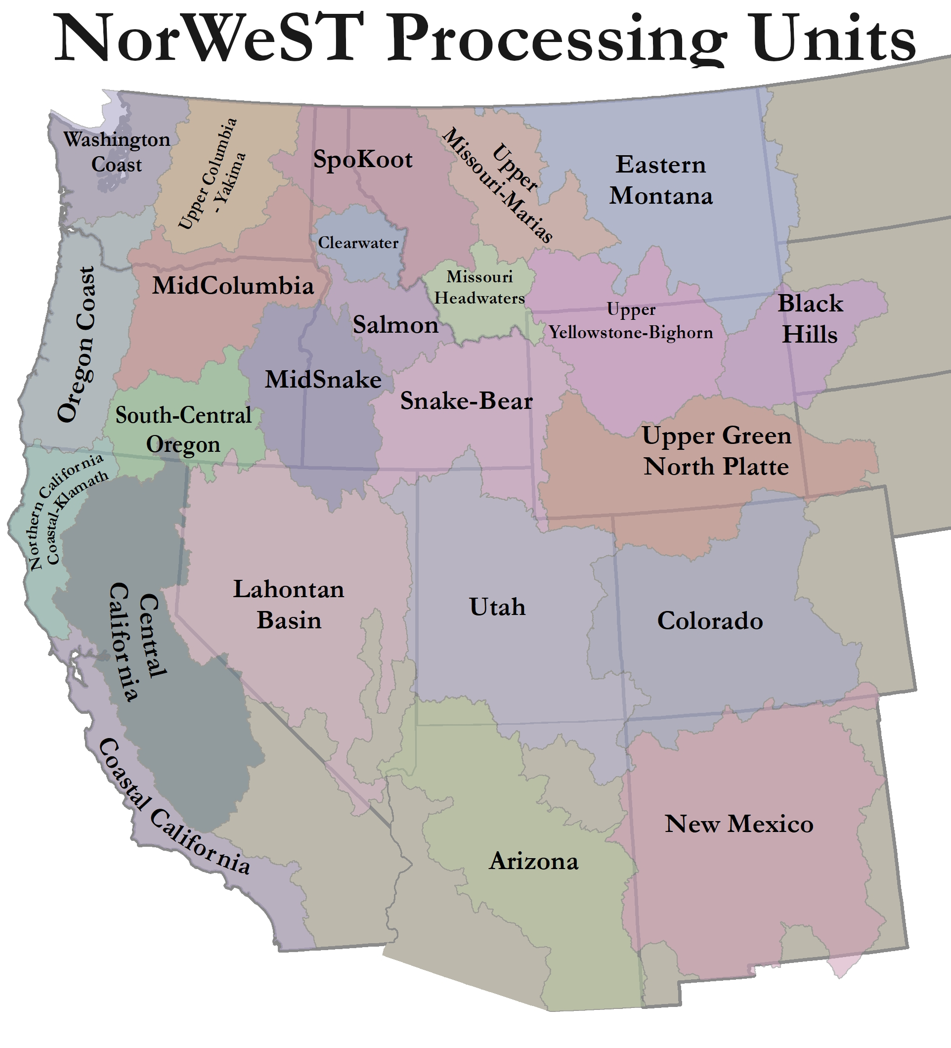
Links to more data and maps:

R and SSN files used to fit temperature models - Upper Columbia-Yakima

NorWeST Modeled Stream Temperature Scenario Maps throughout the West

NorWeST Observed Stream Temperature Data Summaries and database throughout the West

Utah State-Wide Stream Temperature Data and Summaries

Mid-Columbia East Stream Temperature Data and Summaries

Upper Columbia-Yakima Stream Temperature Data and Summaries

Full year Salmon River Watershed Scenarios

Online interactive map of all completed modeled production unit streams and points (AGOL)

NorWeST Thermal Maps by state

National Stream Internet - Reconditioned NHD Plus v2 Streams (GIS)

Find W&W and follow us on your favorite social media site:

facebook
twitter
youtube
email


  |  RMRS Home  |   W&W Home  |   Disclaimers  |   Freedom of Information Act (FOIA)  |   Privacy Notice  |   Quality of Information  |   Print This Page  |