USDA, RMRS, AWAE logo USDA RMRS AWAE RMRS
  • ABOUT W&W
    • About Us
    • Scientist Profiles
  • RESEARCH
    • Aquatic Ecology
    • Atmospheric Sciences
    • Biogeochemistry
    • Climate Change
    • Engineering
    • Fire & Fuels
    • Fisheries
    • Geomorphology
    • Hydrology
    • Invasive Species
    • Plant Physiology
    • Sediment & Erosion
    • Spatial Analysis
    • Watershed Processes
  • PROJECTS, TOOLS, & DATA
    • Click for Complete List of W&W Projects, Tools, & Data
    • The Aquatic eDNAtlas Project
      • eDNAtlas Sample Results
      • Supporting Science
      • FAQ & Field Protocol
      • eDNA Sampling Grid
      • Project Background
      • Contacts
    • Bull Trout eDNA Project
      • eDNA Sampling & Supporting Science
      • Participating in the Bull Trout eDNA Survey
      • Bull Trout eDNA Sample Sites
      • The Status of the Bull Trout Survey
      • Partners
    • Cold-Water Climate Shield
      • Presentations & Publications
      • Digital Maps & ArcGIS Shapefiles
      • Data Sources & Documentation
      • Trout Distribution Monitoring
      • Related Links
        • NorWeST: Regional Database & Modeled Stream Temperature
        • SSN & STARS
        • Stream Temperature Monitoring & Modeling
        • U.S. Stream Flow Metric Dataset
    • Cutthroat trout-rainbow trout hybridization
    • Fire & Aquatic Ecosystems
      • Management Questions
      • Publications
        • Manuscripts & Reports
        • Fire & Aquatic Bibliography
        • Science Briefings
          • Adaptation for Wildland Aquatic Resources
          • Climate Change & Wildfires
          • Wildfire Impacts on Stream Sedimentation
      • Workshops
        • 2009
          • Agenda
          • Topics & Contacts
        • 2002
          • Author Profiles
          • Special Issue in Forest Ecology and Management
          • Downloadable Papers
      • Links
      • Photo Gallery
    • Geomorphic Road Analysis & Inventory Package (GRAIP)
      • Introduction
      • Case Studies
        • Legacy Roads
        • Watershed Studies
      • Publications
        • Manuals
        • Selected Articles
        • Science Briefings
        • Posters
      • Downloads & Software
        • Database Update (2013)
        • Data Dictionary 5.0
        • Terrain Analysis (TauDEM)
      • Supporting Information
        • Calculating Base Rate
        • List of Equipment
      • Photo Galleries
        • GRAIP
        • Legacy Roads
        • Other Roads
      • Links & Models
        • FishXing
        • WEPP
        • SEDMODL2
        • STREAM TEAM
        • Water-Road Interaction Technology Series
      • Training Opportunities
      • Jobs & Summer Employment
      • Frequently Asked Questions
      • Contacts
    • GRAIP_Lite
      • Manuals & Publications
      • GRAIP_Lite FAQs
      • Training Opportunities
      • Contacts
      • GRAIP_Lite Download
      • Case Studies
    • Managing Arid and Semi-Arid Watersheds
      • about
      • basics
      • bibliography
      • bibliography - supplemental
      • credits
      • data policy
      • U.S. LTER Watershed Sites
      • history
      • links
      • web resources
    • National Stream Internet
      • Workshops and Presentations
      • NSI Hydrography Network
      • Databases of Stream Reach Descriptors
      • Databases of Stream Measurements
      • SSN Bibliography
    • NorWeST: Regional Database & Modeled Stream Temperature
      • Project Boundary
      • Data Downloads
        • Stream Temperature Database
        • Modeled Stream Temperatures
      • Interactive Map
      • Publications
        • Supporting Research
        • Science Briefings
        • Posters & Presentations
        • Blogs & Newsletters
      • Supporting Information
        • Reconditioned NHD Plus
        • Regional Climate Downscaling
        • Climate-Aquatics Blog
        • 2011 Climate-Aquatics Decision Support Workshop
      • Related Links
        • Cold-Water Climate Shield
        • SSN & STARS
        • Stream Temperature Monitoring & Modeling
        • U.S. Stream Flow Metric Dataset
      • Contacts & Contributors
    • Sediment Transport
      • Idaho & Nevada
        • Publications
        • FAQ & Contact Us
      • Colorado & Wyoming
        • Publications
        • FAQ & Contact Us
    • Spatial Statistical Modeling of Streams (SSN & STARS)
      • Frequently Asked Questions
      • Software & Data
      • GIS Layers
      • Publications & Presentations
      • Latest Releases
      • Authors & Contacts
      • Other Software
      • News
    • Stream Temperature Monitoring & Modeling
      • Protocols and Resources
      • Interactive Maps
      • Modeling
        • Air Temperature Model
        • Multiple Regression Model
        • Spatial Statistical Model
        • SSN & STARS
        • NorWeST
      • Resources
        • Climate Change Resource Center
        • Climate-Aquatics Blog
        • Climate-Aquatics Workshop
        • Temperature Data Macro
      • Publications
        • Publications & Presentations
        • Science Briefings
    • Understanding the diversity of Cottus in western North America
      • Current Contributions
      • Phylogeny and Maps
      • Publications and Posters
      • Contact
    • Valley Bottom Confinement
      • Download Valley Bottom Shapefiles
      • Download VCA Script & Toolbox
      • Publications
    • Water Erosion Prediction Project (WEPP)
      • Forest Management
        • Disturbed WEPP
        • Disturbed WEPP Batch
        • ERMiT
        • ERMiT Batch
        • WEPP FuME
        • Tahoe Basin Sediment Model
      • Road Erosion
        • WEPP: Road
        • WEPP: Road Batch
      • Fire Effects
        • Disturbed WEPP
        • Disturbed WEPP Batch
        • ERMiT
        • ERMiT Batch
        • WEPP FuME
      • WEPP Climate Parameter Files
        • Rock:Clime
      • Peak Flow Calculator
      • Additional WEPP Resources
    • U.S. Stream Flow Metric Dataset
      • Dataset Downloads
      • Publications
        • Macroscale Hydrologic Modeling
        • Comparison of VIC/MC1 Models to Observed Gage Data
        • Science Briefing
      • Contacts
        • Charlie Luce
        • Seth Wenger
      • Links
        • NHD Plus
        • University of Washington Climate Impacts Group
        • Trout Unlimited Science Page
        • Climate-Aquatics Blog
      • Related Websites
        • SSN & STARS
        • Reconditioned NHD Plus
        • NorWeST Stream Temperature
        • Stream Temperature Modeling & Monitoring
  • PUBLICATIONS
    • Search Publications (TreeSearch)
    • Recent W&W Publications
    • All Available W&W Publications
    • Publications by Project or Research Subject
      • Biogeochemistry
      • Environmental DNA
      • Climate Change
      • Engineering
      • Fire & Aquatic Ecosystems
      • Geomorphic Road Analysis & Inventory Package (GRAIP)
      • Glacier Lakes Ecosystem Experiments Site (GLEES)
      • Invasive Aquatic Species
      • NorWeST Stream Temperature Regional Database & Model
      • River Bathymetry Toolkit (RBT)
      • Sediment Transport
        • Idaho/Nevada
        • Colorado/Wyoming
      • Spatial Statistical Modeling of Stream Networks (SSN & STARS)
      • Stream Temperature Modeling & Monitoring
      • Threats Assessment for Western Riparian Ecosystems
    • Science Briefings
      • Search by Title
      • Search by Researcher
      • Search by Subject
    • General Technical Reports
      • Search by Title
      • Search by Researcher
      • Search by Subject
  • CONTACT US
    • Locations
      • Albuquerque Forestry Sciences Lab
      • Boise Aquatic Sciences Lab
      • Flagstaff Forestry Sciences Lab
      • Fort Collins Biogeochemistry Lab
      • Fort Collins Forestry Sciences Lab
      • Missoula Fire Sciences Lab
      • Moscow Forestry Sciences Lab
    • Employee Profiles
    • Jobs & Employment
    • Website Feedback
    search only W&W
Home    Projects    The Aquatic eDNAtlas Project

Welcome to the Aquatic eDNAtlas Project!

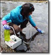
The eDNAtlas is an open-access database developed through crowd-sourced field surveys that provides precise spatial information on the occurrence locations of aquatic species in the U.S. The eDNA samples constituting the database are collected using a standardized field sampling protocol by numerous natural resource agencies and non-governmental organizations partnered with the National Genomics Center for Wildlife and Fish Conservation (NGC), which is a science collaborative within the Rocky Mountain Research Station of the U.S. Forest Service. The eDNAtlas database contains results from thousands of sites and dozens of species and is annually updated with additional results for a growing list of species. Funding to develop the eDNAtlas database was provided by the National Fish and Wildlife Foundation Bring Back the Natives Program.

Here you'll find information about:

  • The project background, additional information, and contributing partners.
  • The science supporting eDNA sampling.
  • The eDNAtlas, a map-based portal to the results of analyses of eDNA samples that can be downloaded in digital formats with metadata
    • A user guide for the eDNAtlas data portal.

For developing your own collaborative project with the NGC involving eDNA sampling and the eDNAtlas, there is information about:

  • FAQ and information for conducting an eDNA sampling survey.
  • Contacts, including a one-page form for outlining your eDNA sampling needs.
  • A national grid of stream-based eDNA sampling points at ~1-km intervals based on the U.S. National Hydrography Dataset, that provides a geospatial template to design efficient eDNA surveys.
  • 2020 Science You Can Use bulletin - Black and White and Shed All Over: How eDNA Analysis Can Help to Answer Your Species Questions.
 

Resources

Aquatic eDNAtlas Sample Results Map
Aquatic eDNAtlas Supporting Science and Peer-Review publications
Aquatic eDNAtlas Project - Field Sampling Protocol
eDNA Sampling sites coordinates to prepare for field work

The eDNAtlas

Supporting Science

FAQ & Field Protocol

eDNA Sampling Grid


Related Websites

The National Stream Internet

NorWeST: Regional Database & Modeled Stream Temperature

SSN & STARS: Tools for Spatial Statistical Modeling on Stream Networks

Climate Shield Cold-Water Refuge Streams for Native Trout

Stream Temperature Modeling and Monitoring

Climate-Aquatics Blog

U.S. Stream Flow Metric Dataset

National Genomics Center for Wildlife and Fish Conservation

Sculpins of the West - A molecular taxonomy of Cottus in western North America

The Range-Wide Bull Trout eDNA Project

Cutthroat trout-rainbow trout hybridization


  Home    Projects    The Aquatic eDNAtlas Project  

Find W&W and follow us on your favorite social media site:

facebook
twitter
youtube
email


  |  RMRS Home  |   W&W Home  |   Disclaimers  |   Freedom of Information Act (FOIA)  |   Privacy Notice  |   Quality of Information  |   Print This Page  |