

Cross-boundary partnership brings together lands and people to prevent future wildfires
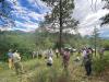
Forest Service and partners during a field tour on the San Juan National Forest. (The Forest Stewards Guild photo by Esme Cadiente)
Across the arid Southwest, prolonged drought, increased fuel loading and past fire exclusion left many communities at risk for catastrophic wildfire."We've been…
#Partnerships, #WildfireCrisis, #RioChama, #NewMexico, #CollaborativeForestLandscapeRestorationProgram, #FirePrevention, #InfrastructureInvestmentAndJobsAct, #Fire, #Partnerships
Wildfires: When Fun Turns to Flames

Humans cause anywhere between 85% and 97% of all reported wildfires. Visitors should be sure to know and understand the daily Fire Danger Rating which indicates the potential for a fire to ignite, spread and require action from wildland firefighters. (USDA Photo by Lance Cheung)
Heavy, dark clouds roll over…
#PrescribedFire, #Fire, #FirePrevention, #WildfirePrevention
Predicting Where Wildfires Will Start
Predicting where wildfires will start in fire-prone areas in the United States will assist fire managers with decision-making. The data collected will be used in developing wildland fire potential forecasts.Currently, fire managers are evaluating existing forecasts and data systems to coordinate among agencies to define criteria.Fire managers are implementing the Severe Fire Weather…
#Fire, #FireAndAviationManagement, #Wildfire, #WildfireCrisis, #WildfireCrisisStrategy, #FirePrevention
Fire Adapted Communities
Structures that are closely surrounded by trees and brush are more likely to burn in a wildfire. (USDA Forest Service image)
More than 70,000 communities and 46 million homes are at risk from wildfire in the wildland urban interface (WUI) – where undeveloped wildland and the built environment meet. Over the last ten years, more than 35,000 structures were destroyed by wildfires – an average of…