

Salvaging success

When a tornado swept through the Sabine National Forest in March 2025, it left behind a trail of broken trees, downed limbs and hundreds of acres of damaged timber. But in just 28 days, the Forest Service, an agency of the U.S. Department of Agriculture, turned destruction into opportunity by mobilizing resources, assessing the damage and awarding two salvage stewardship sales to help…
#SabineNationalForest, #Timber, #Restoration, #Texas, #NationalForestsAndGrasslandsInTexas, #FirePrevention, #Hazards, #HazardousFuels, #Weather, #FuelLoads, #FuelReduction
Going digital

An area treated using digital marking. Fewer trees, farther apart helps promote a healthy forest by reducing the amount of fuel for a potential wildfire. (Image courtesy of The Nature Conservancy)
With a paint can in hand, a forester walks step by step through the dense Arizona ponderosa pine…
#MechanicalThinning, #Thinning, #FuelsTreatment, #TimberSales, #Timber, #CoconinoNationalForest, #WildfireRiskReduction, #FuelReduction
Saving historic Mount Wilson and crucial communications from Eaton Fire

wistia-player[media-id='qaw79o7sd9']:not(:defined) { background: center / contain no-repeat url('https://fast.wistia.com/embed/medias/qaw79o7sd9/swatch'); display: block; filter: blur(5px); padding-top:56.25%; } The Mount Wilson Observatory and communications equipment at the summit of Mount Wilson were protected both by actions taken by firefighters during the Eaton Fire and treatments…
#PrescribedFire, #WildlandFirefighters, #HazardousFuels, #FuelReduction
Where the city meets the forest
Los Angeles skyline with the Angeles National Forest in the background. (USDA Forest Service photo by Andrew Avitt)
Editor’s note: The Forest Service, now in its second year of implementing its Wildfire Crisis Strategy, is treating 11 additional landscapes across the country to help reduce wildfire risk to communities. Combined with the initial 10…
#California, #FuelReduction, #ConfrontingTheWildfireCrisis, #Landscapes
Reducing wildfire risk and supporting rural economies
This aerial view of Lincoln County illustrates the heavily forested lands intermixed with homes and infrastructure. (USDA Forest Service photo)
Lincoln County Montana is a beautiful place. Heavily forested, with the Cabinet Mountains as a backdrop, the vistas are what draw people here.…
#Smoke, #RuralCommunities, #Landscapes, #PileBurning, #ConfrontingTheWildfireCrisis, #FuelReduction
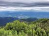
Protecting the Stanislaus Landscape

Part of the National Recreation Trails system, the Pinecrest Lake loop is one of the premiere hiking trails in the state of California and the entry way to the sublime -- Cleo’s Bath. Follow the trail around to the sign for Cleo’s Bath, turn off the main trail and begin your ascent higher into the eastern the Sierra Nevada. (USDA Forest Service Photo by Benjamin Cossel).
For many residents of…