

Confronting the Wildfire Crisis: Implementation Plan

The implementation of the Wildfire Crisis Strategy details how the Forest Service will work with our partners to identify projects and begin work to mitigate the wildfire crisis. It is the second installment of "Confronting the Wildfire Crisis."
#WildfireCrisisStrategy, #PrescribedFire, #Wildfire, #LandManagement, #NaturalResources, #Partnerships
US and Brazil train to better communicate, inform and educate during wildfires
A student gives a live, on-camera TV interview to practice communication skills and how to interact with reporters. USDA Forest Service photo by Suelene Couto.
Washington, DC—Your coworker arrives in the office and says during her commute she saw smoke in the direction of the forest nearby…
#InternationalPrograms, #Wildfire, public information officer, #Education, Communications
Engaging the fire science community to learn from fire management
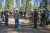
Fire personnel from the Green Mountain & Finger Lakes National Forests pose proudly in the ‘Dome,’ a fire-adapted oak-pine forest where they have been reintroducing fire with prescribed burns. USDA Forest Service photo.
VERMONT—The Green Mountain National Forest Fire Team recently held…
#Wildfire, #PrescribedFire, #NewEngland
Protecting the North Yuba landscape with thousands of forest acres thinned and restored in California
Since 2018, partners have been working together to collaboratively plan, analyze, finance, and implement forest restoration across the North Yuba River watershed in Tahoe National Forest. Photo courtesy of Yuba Water Agency
Established in the Sierra Nevada during the Gold Rush of 1849,…
#Wildfire, #NorthYubaForestPartnership, #TahoeNationalForest, #InfrastructureInvestmentAndJobsAct, #WildfireCrisisStrategy, #Restoration, #LandscapeResilience, #PrescribedFire, #MechanicalThinning, #WildfireRiskReduction
Science shows that demographics and funding impact wildfire resilience

Damage after the Woolsey Fire in California. Economists recognize that the vulnerable populations who are less able to invest in risk mitigation activities may depend more heavily upon federal disaster assistance to help them recover after wildfire events. (USDA Forest Service photo by Peter…
#Wildfire, #Fire, #Resilience, #Science, #FireScience, #InfrastructureInvestmentAndJobsAct, #DefensibleSpace
Confronting the Wildfire Crisis: Update

This update to the January 2022 strategy document, "Confronting the Wildfire Crisis," examines the progress made during the first year of the strategy. It reports on work accomplished across the 10 initial landscape-scale projects through the funding provided by the Bipartisan Infrastructure Law of 2021.