

Alaska Region Viewing Area
LOCATION and PHOTOS


This large deep blue gentian (Gentiana platypetala) is an endemic to south coastal Alaska and north coastal British Columbia; where it grows in subalpine meadows.

Montane forest along the higher elevations of Harbor Mountain road, with the peak of Harbor Mountain in the background. Common trees in this forest include mountain hemlock and Sitka spruce.
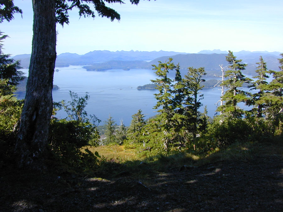
A view down a slope of Harbor Mountain showing a subalpine meadow and gnarled trees.
Harbor Mountain Recreation Area
Forest: Tongass National Forest
District: Sitka
Description: Harbor Mountain Recreation Area is the only place in southeastern Alaska where it is possible to drive from sea level to the subalpine. The road up the mountain winds through temperate coniferous rainforests. At an elevation of about 1900 feet the road passes through the timberline and emerges into a mosaic of sub-alpine meadows. The road and associated trails provide access to stunted forests, alpine tundra and windswept rock outcrops.
Viewing Information: The vegetation along the lower portion of the road is dominated by forests of western hemlock and Sitka spruce. Western hemlock can be recognized by its flat round-tipped needles and distinctive droopy top. Sitka spruce, the Alaska State tree, has sharp-tipped needles, and an erect tree-top. The forest understory generally consists of rusty Menziesia, huckleberry, blueberry and devil's club. At forest edges and in clearings, dense thickets of other shrubs including salmonberry, and Sitka alder are common. The forest floor is generally thickly carpeted in an array of mosses and liverworts. These tiny plants also blanket the decaying jumble of fallen trees and branches that are so abundant in these forests. In some places, where adequate light is available, the forest floor may support plants such as oak fern, bunchberry, foamflower and single delight.
There are many openings scattered throughout in the forest, which are boggy areas, locally called muskegs. These range in size from a few square feet to many acres. Sphagnum moss and small sedges form a spongy mat of vegetation in these very wet, essentially treeless areas. The hummocky, low vegetation is broken by occasional irregularly sized pools and a few gnarled, stunted lodgepole pines and yellow cedar. Low-growing evergreen shrubs, wildflowers, such as bog orchids, Jeffery shooting-star and insect-eating plants (sundew) are abundant in the bogs.
Approaching treeline the composition of the forest changes and mountain hemlock becomes a dominant tree. The branches of these trees are often draped with festoons of witch’s hair lichen. At this elevation, alpine meadows of varying sizes interrupt the forest.
Subalpine meadows begin to dominate the landscape as the road reaches the 1900 foot level. Here the road levels out, and the vegetation changes to subalpine meadow communities. These include, low-growing dense heaths of cassiope, crowberry, and lowbush blueberry; pure stands of deer cabbage, which is recognizable by its leathery, kidney-shaped leaves; wet sedge meadows; herbaceous wildflower meadows with large-leaf gentian, chocolate lily, western columbine, geranium, paintbrush, Sitka valerian and mountain wood-fern, These subalpine meadows are interspersed with wind contorted mountain hemlock, Sitka spruce and yellow cedar, many of them bearded with lichen. An interesting forest-edge shrub in this area is the copperbush, a member of the heather family, spectacular with its inch-in-diameter, copper-colored, five-petaled flowers and shiny leaves. The road continues on through various types of subalpine meadows for about ¾ mile to a parking area loop at the end of the road.
The Harbor Mountain trail begins at the parking area, and is marked by a bulletin board. The trail climbs up about 300 feet through a forested area in a series of switchbacks to a large open herbaceous subalpine meadow on a ridge. The trail turns to the right and follows the ridge toward the summit of a knob that, on a clear day, affords sweeping views in almost any direction. Visible on a clear day are the Fairweather Range, 100 miles to the north; Mt. Edgecumbe, a dormant volcano 15 miles to the west; the open Pacific Ocean to the west; the craggy peaks of central Baranof Island to the East and the town of Sitka, at the base of Harbor Mountain.
The trail turns east (or left) and runs along the top of a steep north-facing meadow. Portions of the trail here weave through Krumholtz forests of dwarfed Sitka spruce. Instead of reaching the peaks of Harbor Mountain, the trail forks to the right and skirts the mountainside, following a cirque around to join the Gavan Hill Trail. Some of the herbaceous meadows along this stretch of the trail support especially spectacular mountain wildflowers. A small emergency shelter is located in the saddle connecting Harbor Mountain Ridge to Gavan Hill Ridge. Information about the shelter and Gavan Hill portion of the trail is available at the Sitka Ranger District.
Safety First: The Harbor Mountain Road is a steep, one lane, gravel road with numerous sharp switchbacks and few turnouts. It is not suitable for motor homes, RV’s, busses, trailers or large vans.
In the wet, windy weather of southeastern Alaska, hypothermia is a very real hazard. Be sure to carry the appropriate clothing to stay warm and dry in this damp and cool environment.
Directions: Drive approximately 4 miles northwest of Sitka along Halibut Point Road. Turn right just before the Channel Club restaurant onto the road leading to Harbor Mountain. After the first mile, the road narrows and turns up the mountain. The steep, one lane, gravel road winds about 4 miles up Harbor Mountain before leveling off just below 2000 feet. The last 3/4 mile of the trail is essentially level. The road ends at a parking loop, and at the head of the Harbor Mountain/Gavan Hill ridge trail system.
Ownership and Management: U.S. Forest Service, Tongass National Forest, Sitka Ranger District. (907) 747-6671.
Closest Town: Sitka, Alaska